Google Earth Imagery Update January

It’s a new year and what better way to usher it in than with new aerial and satellite imagery published by the Google Earth and Maps Imagery Team! In this post, we’ll explore several international features captured in this latest update.

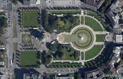
Our first example is part of an aerial image acquired last August of the central park grounds, fountain, and wasserturm (water tower) of Mannheim, Germany. Mannheim is the city where Karl Benz built and tested the world’s first automobile.

Mannheim Water Tower, Mannheim, Germany

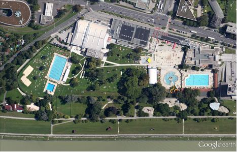
Our next aerial example, also acquired last August, shows the water parks of Linz, Austria, adjacent to the Danube River. The park makes up part of the “Kulturmeile” (“culture mile”) that includes museums and concert halls.

Sun and water bathers, Linz, Austria


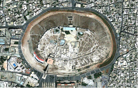
The satellite image below shows the medieval grounds and structures of one of the oldest castles in the world, the Citadel of Aleppo in Syria. The citadel sits on a large hill that has been in use since the 3rd millenium BC, and is outlined by perimeter walls and a foundation that reaches 50 meters in height.

Citadel of Aleppo, Syria

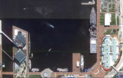
This next satellite image highlights a section of the Great Wall of China in Badaling, Yanqing County, China. This site is the most visited section of the wall, and hosted U.S. President Nixon and Vice Premier Li Xiannian during Nixon’s historic visit to China.

Section of the Great Wall of China in Badaling, Yanqing County, China

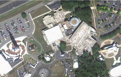
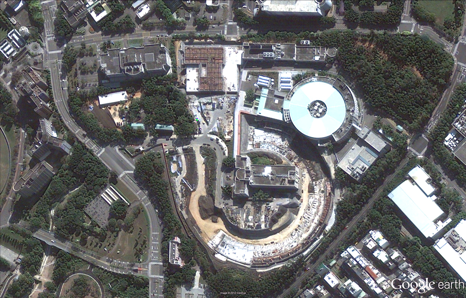
Lastly, shown below is a satellite image of the National Synchrotron Radiation Research Center, in Dong, Taiwan. Shown at bottom center is the partially built circular Taiwan Photon Source facility, due to be completed in 2013.

National Synchrotron Radiation Center, Dong, Taiwan

If you’d like to receive an email notification when the Google Earth and Maps Imagery team updates your favorite site(s), we’ve got just the tool: The Follow Your World application!

These are only a few examples of the types of features that can be seen and discovered in our latest batch of published imagery. Happy exploring!

High resolution aerial updates:
USA: Baton Rouge, LA; Brady, TX; Downieville, CA; East Bay, CA; El Paso, TX; Greenwood, MS; Greenwood, SC; Kingman AZ; Level Land, TX; Long View, TX; Lufkin, TX; Ozona, TX; Quincy, CA; Radium Springs, NM; San Angelo, TX

Austria: Innsbruck, Linz,
Germany: Augsburg, Mannheim

Countries/regions receiving high resolution satellite updates:
Algeria, Argentina, Australia, Austria, Bangladesh, Belarus, Benin, Bhutan, Bolivia, Botswana, Brazil, Bulgaria, Burkina Faso, Burundi, Cameroon, Canada, Cape Verde, Central African Republic, Chad, Chile, China, Colombia, Comoros, Costa Rica, Croatia, Cuba, Cyprus, Czech Republic, Côte d’Ivoire, Democratic Republic of the Congo, Djibouti, Dominican Republic, Ecuador, Egypt, Eritrea, Ethiopia, Finland, France, French Polynesia, Germany, Ghana, Greece, Greenland, Guatemala, Guinea, Haiti, Honduras, Hungary, India, Indonesia, Iran, Ireland, Italy, Japan, Jordan, Kazakhstan, Kenya, Kuwait, Lesotho, Libya, Madagascar, Malawi, Marshall Islands, Mexico, Mongolia, Morocco, Mozambique, Myanmar, Namibia, Nepal, New Zealand, Niger, Nigeria, North Korea, Oman, Pakistan, Papua New Guinea, Paraguay, Peru, Philippines, Poland, Portugal, Qatar, Republic of Korea, Romania, Russia, Rwanda, Saudi Arabia, Senegal, Serbia, Sierra Leone, Slovakia, Somalia, South Africa, Spain, Sri Lanka, Sudan, Svalbard, Swaziland, Sweden, Switzerland, Syria, Tajikistan, Tanzania, Thailand, Togo, Tunisia, Turkey, Uganda, Ukraine, United Arab Emirates, United Kingdom, United States, Uruguay, Uzbekistan, Venezuela, Vietnam, West Bank, Yemen, Zambia, Zimbabwe


Imagery Update – Week of February 21st

We’re just nearly two months into the new year but the Google Earth and Google Maps Imagery team’s aerial and satellite imagery updates keep coming!

Since it’s February, love is in the air and romance is on people’s minds (I mean, why stop at Valentine’s Day). And when it comes to all things amatory, no features and locations conjure up those feelings better than châteaux, castles, and royal wedding sites. Lucky for all our quixotic Earth and Maps users, we’ve got all that and more in our latest batch of published images.

Let’s start with the big one in the room. The Royal wedding isn’t until April, but we’re getting ready for the big day by updating London, UK and wedding-related sites with high-resolution aerial imagery acquired this past June. In the image below, you can see the site of the royal wedding, the Collegiate Church of St Peter at Westminster, more commonly referred to as Westminster Abbey. While viewing this site in Google Earth, make sure you turn on the Photos Layer, and check out the several pano360 immersive images that dot the church confines.

Westminster Abbey, London, UK

Let’s move west a bit to the beautiful Emerald Isle. Below we’re looking at Trim Castle and adjacent grounds in the county town of Trim, in County Meath, Ireland. The castle is the remains of Ireland’s largest and dates to the 11th century. As with the Westminster Abbey location, make sure to click on the Photos layer and check out the pano360 images; the immersive images include 360° views of the castle interior.

Trim Castle, Trim, Ireland.

Lastly, let’s take a look below at some new aerial imagery of a section of the Biltmore Estate which contains the châteauesque house, the Biltmore (upper-right section of the image). The house was finished in 1895 and is located near Asheville, North Carolina. It is the largest privately-owned home in the U.S., owned continuously by members of the William Vanderbilt family.

The Biltmore Estate, Asheville, NC.

Do you have a place you love that you’d want to receive notification from us when the Earth and Maps Imagery team updates your beloved site? We’ve got just the tool: The Follow Your World application!

As always, these are but a few examples of the types of features that can be seen and discovered in our latest batch of published imagery. Happy exploring!

High Resolution Aerial Updates:

USA: Asheville, NC; Charleston, WV; Chattanooga, TN; Daytona, FL; Fayetteville, AR; Key West, FL; Perry, FL; Wachula, FL

Ireland: Kells; Navan; Omagh; Strabane; Trim

UK: Greater London; Immingham; Somerset

Switzerland: Valais

Countries/Regions receiving High Resolution Satellite Updates:

Algeria, Angola, Argentina, Australia, Austria, Bangladesh, Bolivia, Botswana, Brazil, Bulgaria, Burundi, Canada, Central African Republic, Chile, China, Colombia, Costa Rica, Cuba, Czech Republic, Côte d’Ivoire, Democratic Republic of the Congo, Dominican Republic, Ecuador, Egypt, El Salvador, Ethiopia, Faroe Islands, Finland, France, French Guiana, Germany, Greece, Guatemala, Haiti, Honduras, India, Indonesia, Iran, Ireland, Israel, Italy, Japan, Jordan, Kazakhstan, Kenya, Kuwait, Kyrgyzstan, Lebanon, Lesotho, Libya, Macedonia (FRYOM), Mexico, Morocco, Mozambique, Myanmar (Burma), Namibia, Nepal, New Zealand, Nicaragua, Niger, Nigeria, Norway, North Korea, Oman, Pakistan, Panama, Paraguay, People’s Republic of the Congo, Peru, Poland, Republic of Korea, Romania, Russia, Rwanda, Saudi Arabia, Somalia, South Africa, Spain, Sri Lanka, Sudan, Suriname, Swaziland, Sweden, Switzerland, Syria, Tajikistan, Tanzania, Thailand, Togo, Trinidad and Tobago, Tunisia, Turkey, Turkmenistan, Uganda, United Arab Emirates, United Kingdom, United States, Uruguay, Uzbekistan, Venezuela, West Bank, Yemen, Zambia, Zimbabwe

These updates are now available in both Google Maps and Google Earth. To get a complete picture of where we updated imagery, download this KML for viewing in Google Earth.

Imagery Update – Week of November 1st

The Google Earth and Maps Imagery team has just released another extensive batch of aeriel and satellite images for your enjoyment! In honor of the upcoming U.S. holiday Veterans Day (November 11th), we’ll take a look at a few military-themed museums.

Let’s start with a wide-view of the naval ships on display at the Baltimore Maritime Museum in Baltimore, Maryland. Historic ships that you can zoom in on and see close up in Google Earth or Maps include the last sail-only warship USS Constellation (lower left); the submarine USS Torsk (upper left) which sunk the last enemy ship in World War II; and the cutter USCGC Taney (upper right), the last ship still floating that fought during the Pearl Harbor attack.

Baltimore Maritime Museum in Baltimore, MD

Now that we’ve got our sea legs, let move sub-orbital and beyond at the U.S. Space and Rocket Center in Huntsville, Alabama. Here we can see a restored Saturn V-1 “moon shot” test vehicle and the A-12 Oxcart “Blackbird” spy plane.

U.S. Space and Rocket Center in Huntsville, AL

These are just a few examples of the many museums around the globe that are included in our latest imagery batch.

High Resolution Aerial Updates:
USA: Baltimore, Cedar Rapids, Huntsville, Long Island, Redding, Springfield (IL), St. Joseph (MO)
Austria: Schladming
Finland: Pori
Ireland: Athlone, Drogheda, Dundalk, Enniscorthy, Galway, Limerick, Monaghan, Tralee, Waterford,
Spain: Vasco

Countries receiving High Resolution Satellite Updates:
Albania, Algeria, American Samoa, Angola, Argentina, Armenia, Australia, Austria, Azerbaijan, Bangladesh, Belarus, Benin, Bolivia, Botswana, Brazil, Bulgaria, Burkina Faso, Burundi, Cameroon, Canada, Central African Republic, Chad, Chile, China, Colombia, Costa Rica, Cuba, Côte d’Ivoire, Democratic People’s Republic of Korea, Democratic Republic of the Congo, Ecuador, Egypt, El Salvador, Equatorial Guinea, Eritrea, Ethiopia, Finland, Former Yugoslav Republic of Macedonia, France, Georgia, Germany, Ghana, Greece, Guatemala, Guinea, Guinea-Bissau, Guyana, Honduras, Hungary, India, Indonesia, Iran, Ireland, Kazakhstan, Kenya, Kyrgyzstan, Lesotho, Liberia, Libya, Madagascar, Malawi, Malaysia, Mali, Mauritania, Mauritius, Mexico, Moldova, Mongolia, Montenegro, Morocco, Mozambique, Myanmar, Namibia, Nepal, New Zealand, Nicaragua, Niger, Nigeria, Norway, Oman, Pakistan, Panama, Paraguay, People’s Republic of the Congo, Peru, Philippines, Poland, Portugal, Romania, Russia, Rwanda, Saudi Arabia, Senegal, Sierra Leone, Somalia, South Africa, Spain, Sudan, Suriname, Swaziland, Taiwan, Tajikistan, Tanzania, Thailand, The Bahamas, Togo, Tonga, Tunisia, Turkey, Turkmenistan, Uganda, Ukraine, United Arab Emirates, United Kingdom, United States, Uruguay, Uzbekistan, Venezuela, Vietnam, Yemen, Zambia, Zimbabwe

These updates are currently only available in Google Earth, but they’ll also be in Google Maps soon. To get a complete picture of where we updated imagery, download this KML for viewing in Google Earth.