Two New Data Modules for Bing Maps V7


By Ricky Brundritt, EMEA Bing Maps Technology Solution Professional

In September of 2011 we started the Bing Maps v7 Module CodePlex Project. The purpose of this project is to create a centralized location where developers could find and share useful modules that expand the functionality of the Bing Maps V7 API. Since the start of the project, we’ve had 15 modules submitted.

Today, I would like to highlight the two newest modules added to the project and provide a few updates to existing modules.

GeoJSON Module

Download here

This module was created by Brian Norman a Microsoft Bing Maps MVP from Earthware Ltd.

This module allows you to import GeoJSON files into Bing Maps. A GeoJSON feed will be downloaded and parsed into an EntityCollection which can then be added to the map. Additional properties are captured and stored in a Metadata tag on each shape making it easy to relate shapes to their metadata.

GeoJSON is a data format standard used for representing geospatial objects in JSON (JavaScript Object notation). JSON is much more compact than XML which makes it a great format for sharing spatial data online. In fact the AJAX Map DataConnector uses GeoJSON to send spatial data from SQL Server to Bing Maps.

Well Known Text Reader/Writer Module

Download here

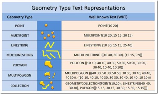
I created this module because I wanted a simple tool for quickly visualizing Well Known Text on Bing Maps. This module allows you to easily read and write Well Know Text data from Bing Maps. When reading Well Known Text data it is parsed into Bing Maps shapes; MultiPoint, MultiLinstring, MultiPolygon and GeometryCollection are turned into an EntityCollection of shapes. To write Well Known Text simply pass in a Bing Maps shape and the Well Known Text equivalent will be returned.

clip_image004

Well Known Text (WKT) is an OGC (Open Geospatial Consortium) standard for representing Geospatial Data. In fact WKT is supported by the spatial types in Microsoft SQL Server 2008 and above as well as SQL Azure.

*Project Idea: Combine this module with the Shape Toolbox Module and make it easy for your users to draw on the map and upload the shape data into Microsoft SQL Server.

*Demo Tip: Use this module to quickly create demos that render complex spatial data. Simply store your Well Known Text in a JavaScript file as a string to save time setting up a web service to connect to your database. Note: this approach is not recommended for production applications as loading all the spatial data via a JavaScript file can make for slow loading of your application.

Other Data Related Modules

GeoRSS Module – GeoRSS is a common XML file format for sharing spatial data as a syndication feed. This module also supports GML, an OGC compliant XML format. This module has been updated to support Complex Polygons (polygons with holes).

GPX Module – GPX is a common XML data format that is used by GPS devices. Many GPS devices allow you to stave points, routes and tracks which can then be exported from the device in GPX format. This module makes it easy to view these files on Bing Maps.
MapMyFITNESS and Google Maps API for Business

Being fit means moving and moving means going someplace. We created the MapMyFITNESS applications because we are passionate about living active lifestyles and we wanted a way to both track our progress and explore new activities. We wanted to help people experience this passion for themselves. As our community of MapMyFITNESS users has grown to over 9 million people, we have continually worked to make the applications easier to use and more effective at motivating people to keep moving, whether they’re elite athletes or people just getting started.

A key component to that mission has been our integration with Google Maps, which has made it easy for our users to find new routes or make their own, then share them with the rest of the MapMyFITNESS community. As one of the earliest Google Maps API developers, we noticed it was easy to incorporate the mapping functionality into our product. As we set about to completely rebuild our platform that launched earlier this month, our goal was to expand the ways users could take advantage of Google Maps’ latest API functionality. We’ve gone from tracking and sharing routes in our old platform to providing “Courses” in our new platform. Courses provide our users with real-time data like traffic patterns and temperature, and include “check-in” technology that helps them track workouts, share their progress, and compete in our new leaderboard against specific groups of people. They can compete with local clubs, friends, and most importantly against themselves and their own progress.

The Google Maps API allowed us to show the important information to our users in an easy to read format. Users can visit our site to find new cycling, running or walking routes by searching for the route while viewing it on the map. By using the Google Maps API were we able to incorporate the Street View API to create virtual tours of routes and the Elevation API to calculate how many feet you climb – and descend – during your workout. That familiarity, in addition to fantastic technology and features, makes the user experience both easier and more powerful.

Travel as a Roman

Stanford University have created a “Geospatial network model of the Roman world”
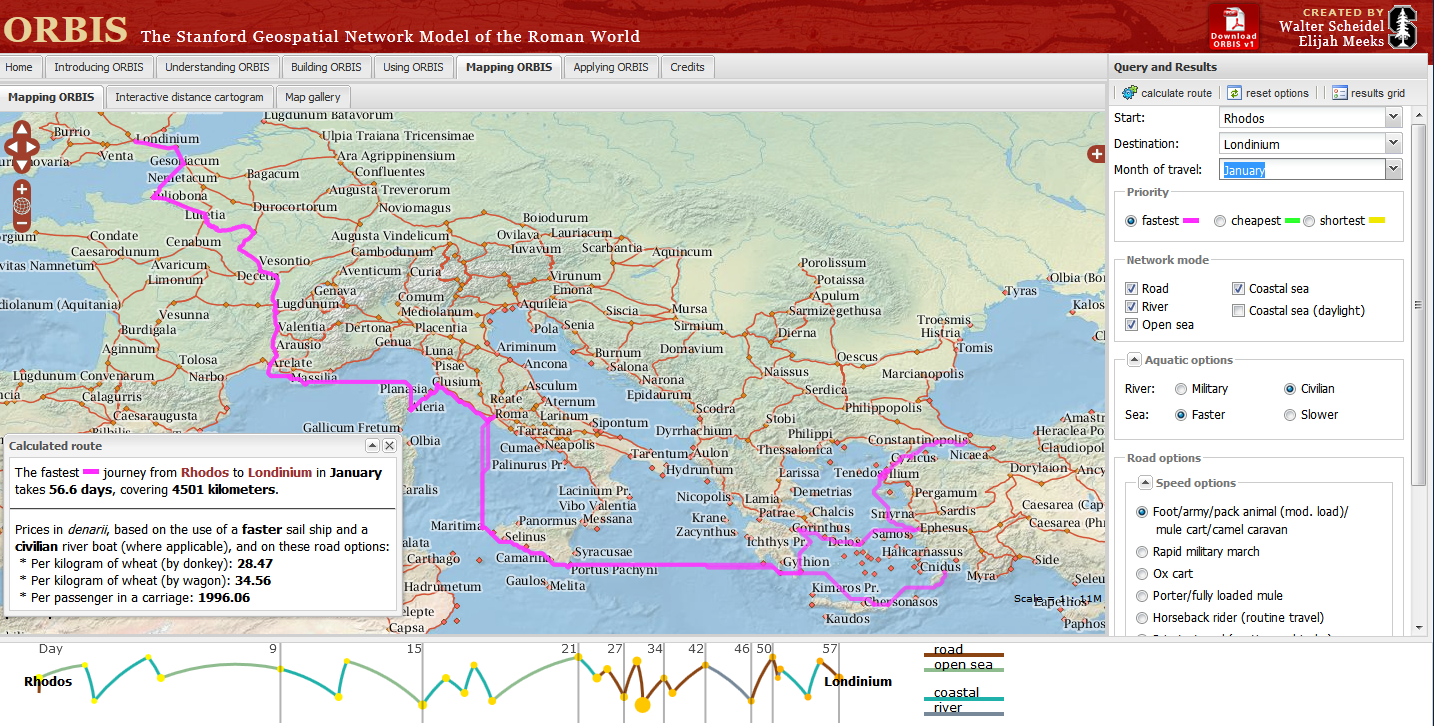
Impressive Interactive Map that can calculate  travel times and cost (in Denarius)
ORBIS, can calculate journey times between 751 locations in the Roman world. The site draws data from The BarringtonAtlas of the Greek and Roman World which has  been georeferenced by Cambridge University Students. To calculate voyages on water, the site uses maps of rivers. Sea journeys are also possible, with routes calculated from the Romans’ preferred sea routes. Dijkstra’s pathfinding algorithmis applied to calculate routes.
The Mapping tool also calculates route dependent on the month for a journey, as weather conditions at sea and on land had a major impact on ancient travel times.
Users can choose from a menu of transport/travel options:
  • Foot/army/pack animal, mule cart/camel caravan
  • Military March (Rapid)
  • Ox & cart
  • Fully loaded mule
  • Horseback rider (routine travel)
  • Private travel (routine, vehicular)
  • Private travel (accelerated, vehicular/horseback)
  • Fast carriage
Try the Roman Travel Interactive Map:
Information on the Geospatial Technology used is see the section tabs:
Building ORBIS: Multi-modal network model via the Building ORBIS tab and selecting the Geospatial Technology Tab.
via:mapperz.blogspot.com