Fresh imagery from Christchurch

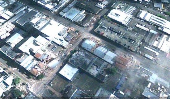
In the wake of the earthquake that struck Christchurch last month, GeoEye captured some fresh imagery of the area and has now made it available to everyone.

While the imagery is a bit cloudy, it really gives a sense of the widespread damage in the area. These images were captured two days after the quake, on February 24.

christchurch.jpg

To view the imagery in Google Earth, they’ve made a few files available for you to download:

Central and Northern Christchurch
Southern Christchurch

As Frank mentioned on the Tahina Expedition blog a few days ago you’re encouraged to contribute to the families affected by the quake on the Christchurch Earthquake Appeal site.

(Via National Business Review)

Hunting for the Megalithic Stone Circle in Morocco

Over the past few years, we’ve seen some great discoveries in Google Earth, including some quite remarkable finds that were only made possible thanks to the widespread high-resolution imagery that is available in Google Earth.

Some examples include a geologist that “accidentally” discovered a meteor crater, another crater in the Saharan Desert, and a buried Peruvian pyramid.

Today we bring you the story of Graham Salisbury, and how he was able to track down the megalithic stone circle of Mzora using a black and white photograph and Google Earth.

mzoura01.jpg

Salisbury quotes several sources as saying it’s “extraordinarily difficult to find” and “one would have to have access to a military satellite to find it“, but he felt that it could be found in Google Earth with enough research and patience.

You can read all of the details on his blog, but he did an excellent job of figuring out which area to search and then tracking down. If you compare the screenshot from Google Earth below with the black and white image above, I think it’s pretty clear that he succeeded.

mzora-ge.jpg

If you’d like to see it for yourself, you can fly there using this KML file.