Before/after shots of the Tuscaloosa storm

In the days following the Japanese earthquake and tsunami, we showed you a great tool from ABC news that used Google Earth imagery with a slider to flip back and forth between pre and post-earthquake imagery.

Now we’ve been shown a similar tool for showing damage from the tornadoes that hit Tuscaloosa, and it’s just as impressive and heart-breaking as the Japanese imagery.

tuscaloosa-slider.jpg

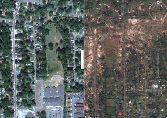
To try it for yourself, simply head over to this page on the Tuscaloosa News site. Use the blue buttons on the right side to select an area to view, and slide the white bar from side-to-side to view the difference in the imagery.

The Tornado – Maps and Images

Earth Observatory: Severe Tornado Outbreak in the Southern United States

NASA’s Earth Observatory has satellite images and animations of the weather system that spawned so many tornadoes this week.

Google Maps’s collection of tornado maps and images. The Wall Street Journal’s map of storm reports. Another map of storm reports.

MSNBC’s tracking map showing the path of the weather system along which tornadoes bloomed. A New York Times map showing hour-by-hour tornado reports.

Satellite and aerial images from before and after the tornadoes: the New York Times’s interactive maps (with the clever slider); a gallery of images from Google.

Tornadoes in Google Earth

With storms again ripping through the country, many of us are on the lookout for tornadoes. While it can’t help you prepare for one, Tornado Paths, created by Perry Samson at the University of Michigan, is a great way to view the locations and paths of past storms.

By default it shows all of the tornadoes that have hit the United States in the past 48 hours, but it has a few other nifty features.

• View “Today in History“, which shows all of the tornadoes that have struck on today’s date in the past 61 years.

• Use the search box to let you see all of the tornadoes that have struck a particular zip code since 1950. Very interesting stuff! For example, I now know that a 1986 tornado came within a few hundred meters of our current house.

tornadoes.jpg

Of course, it makes excellent use of Google Earth too. By clicking the “View in Google Earth 
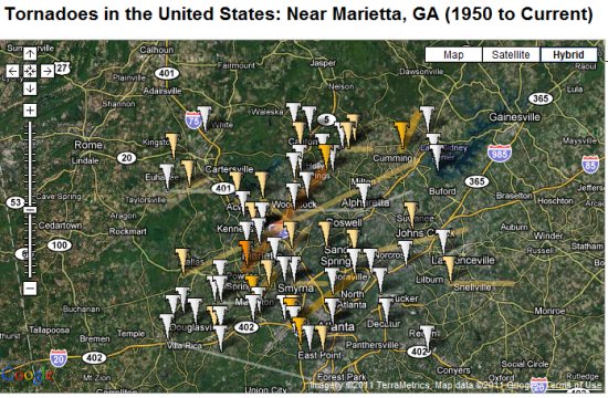
link from the home page, you can view the most recent tornadoes in Google Earth.

tornadoes.jpg

As you can see, the tornadoes have a nice 3D semi-transparent affect, and some cows flying around nearby in an apparent homage to the classic movie “Twister”.