MapMyFITNESS and Google Maps API for Business

Being fit means moving and moving means going someplace. We created the MapMyFITNESS applications because we are passionate about living active lifestyles and we wanted a way to both track our progress and explore new activities. We wanted to help people experience this passion for themselves. As our community of MapMyFITNESS users has grown to over 9 million people, we have continually worked to make the applications easier to use and more effective at motivating people to keep moving, whether they’re elite athletes or people just getting started.

A key component to that mission has been our integration with Google Maps, which has made it easy for our users to find new routes or make their own, then share them with the rest of the MapMyFITNESS community. As one of the earliest Google Maps API developers, we noticed it was easy to incorporate the mapping functionality into our product. As we set about to completely rebuild our platform that launched earlier this month, our goal was to expand the ways users could take advantage of Google Maps’ latest API functionality. We’ve gone from tracking and sharing routes in our old platform to providing “Courses” in our new platform. Courses provide our users with real-time data like traffic patterns and temperature, and include “check-in” technology that helps them track workouts, share their progress, and compete in our new leaderboard against specific groups of people. They can compete with local clubs, friends, and most importantly against themselves and their own progress.

The Google Maps API allowed us to show the important information to our users in an easy to read format. Users can visit our site to find new cycling, running or walking routes by searching for the route while viewing it on the map. By using the Google Maps API were we able to incorporate the Street View API to create virtual tours of routes and the Elevation API to calculate how many feet you climb – and descend – during your workout. That familiarity, in addition to fantastic technology and features, makes the user experience both easier and more powerful.

Pro Case Study

In the second installment of our three-part series profiling Turner Construction Company, we turn our attention to the plugins Turner is developing to increase efficiencies across the global organization. Jim Barrett, Director of Integrated Building Solutions, explains:

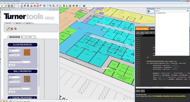
The National Turner Virtual Design and Construction (VDC) team has developed several SketchUp plugins in Ruby to bring existing and evolving VDC processes into the simple, efficient and visual environment of SketchUp Pro.

A proprietary plugin for steel modeling and tracking was created to accelerate the use of Building Information Modeling (BIM) at the World Trade Center Transportation Hub. The tool was written to batch convert single line framing plans into 3D steel sizes, using a standard library of parts. This tool was expanded to report steel takeoffs and is now used throughout Turner to support estimating and pre-construction services.

The Place Steel for Modeling module in Turner’s proprietary SketchUp plugin

By developing our own tools on top of the intuitive interface of SketchUp Pro, we continue to increase operational efficiencies. The place steel plugin is a great example of how streamlining the modeling process by reviewing the process of modeling steel, standardizing the modeling of stock pieces, and integrating that database information into SketchUp Pro reduces redundancy as well as dimensional errors in steel sizing.

Working with several Turner offices including, New York City and Seattle, a takeoff plugin was developed to support Turner’s current approach to “Control Quantity Models” and “Gross Square Foot” takeoffs. This tool allows SketchUp models to be built for different purposes. For example, using client or business unit standards, we still achieve consistent and accurate takeoffs of square footage, count, length and volumes (using SketchUp Pro’s Solid Tools).

The Count Steel for Estimating module of the Turner plugin

Design information is still in its infancy and rapidly changing. Supporting Turner’s evolving estimating expertise, a plugin was developed to accelerate the takeoff process for conceptual estimates. This plugin allows for rapid creation of space and room plans, as well as the detailed takeoff information that is required for estimates.

The Mass Generator for Estimating module

These two takeoff plugins work together to seamlessly streamline the quantity takeoff process developed by estimators in SketchUp Pro. At Turner, we look at opportunities to develop existing processes & workflows using new tools.

A detail view of the Mass Generator for Estimating module

In this way, we aren’t teaching new workflows based on new tools as they come along (a very disruptive process for any business). Rather, we’re able to leverage the skill sets and broad knowledge bases of our VDC team to build streamlined versions of existing workflows into new tools.

The Arctic Tern and the Sea Grapes


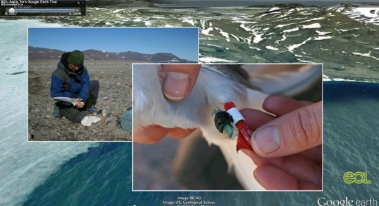
Last fall we showed you a great file from the people at Encyclopedia of Life that tracked Bluefin Tuna across the Atlantic. They’re back with a few new files that show how a type of sea algae (known as “sea grapes”) and Arctic Terns travel across the world as part of their annual migrations.


tern.jpg 

Ari Daniel Shapiro has worked with others, including Marie Studer and Eduardo Garcia Milagros, to put together some remarkable new tours. Ari’s background is in radio, so the audio narrative on the tours is excellent. Combine that with the images, video and Google Earth content and you’ve got a very engrossing and educational result.

The tours are available below, both in KMZ format for you to enjoy:

Sea Grapes Tour | KMZ


Arctic Tern Tour | KMZ


For more, you can view all of their tours on the Encyclopedia of Life site.