Sound Transit: Riding the Bing Maps Wave

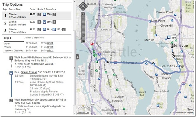
SoundTransit_0Sound Transit has launched their new public transit system featuring Bing Maps and leveraging their repository of public transit information to create a trip planner for Seattleites to get around town. The application allows users to put in origin and destination addresses, set the date and time (defaulting to the current date/time) and start planning their trip. So, let’s say I wanted to travel from the Bellevue Art Museum (510 Bellevue Way NE, Bellevue, WA) to the Seattle Art Museum (1300 1ST AVE, Seattle) – working on that Warhol foursquare badge. So, I input the respective locations, click “Plan Trip” and out pops a map with the full route charted right across the 520 bridge. They’ll soon need to account for the tolls…anyway. Grrr.

SoundTransit_1

The results also include several options with travel time, start and end times, the cost of the trip, the route numbers you’ll need to take, plus any transfers required to get from one museum to the other. Upon drilling down into the trips, you’ll see that there are actually different prices per rider type (adult, youth and senior/disabled) and whether or not you can use your ORCA card (One Region Card for All – basically, one card for all public transportation around Seattle). One of the many perks of being a Microsoft employee is a free ORCA card, so come work for us (!!) or ask more Microsoft people why they aren’t using public transportation since it’s free and there’s a kick ass Microsoft system powering the Sound Transit Trip Planner…just sayin’.

I digress.

Finally, in the trip planner, you’ll also see the distance you may have to walk in the rain (eek!) and then step-by-step driving directions with times included and the transit system which powers the mode of transport.

You’ll also notice some markers on the map. In addition to the route line and stops, there are buttons to enable Fare Outlets (for buying passes) and Park and Rides pinned to the map. These will be quite useful in our attempts to stop the insanity of $4 per gallon gas and global warming. A great addition to the Bing Maps Customer Showcase and a win for Sound Transit riders around Puget Sound.

Don’t live in Seattle? Build your own transit app. Sign up at the Bing Maps Portal.
Google Maps: Helping you find the right route

With directions in Google Maps, we’re working on helping you find the quickest way to get around, and now finding the right route is a bit easier. For areas with transit information in Google Maps, previously you could compare driving and transit directions by selecting the appropriate icon. Now, when you search for driving directions, transit options may appear directly in the results.

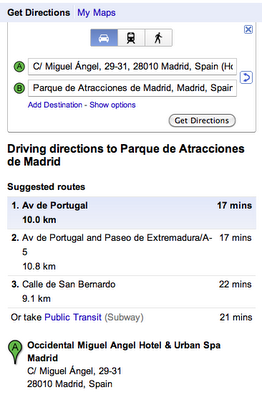
This comes in handy as I visit Madrid and want to find my way from the Hotel Miguel Ángel to the Parque de Atracciones de Madrid. When I search for “Hotel Miguel Ángel, Madrid to Parque de Atracciones de Madrid, Madrid” in Google Maps, I now see the following set of suggestions:

You can see a link to public transit options directly in your driving directions, together with the estimated travel time and number of transfers, for areas where we have transit coverage. This link will appear based on whether public transportation seems like a good alternative for your trip. Similarly, if you’re viewing public transit directions, we may add driving (or taking a taxi) as an alternative.

This feature is currently available in New York, San Francisco, Madrid and Zürich, and we plan to roll this out for more cities in the coming weeks.

Announcing New Bing Maps & Local Features: Interior Views, Enhanced OpenTable Integration, Real-Time Transit, and Streetside for Mobile

Throughout the last few months, Bing Maps & Local has focused on how our product can help with everyday decisions and deliver innovative experiences to a wide audience. The end result is a more functional, easier-to-use, and differentiated experience. The theme for this release has been around three areas: i) Delivering new types of visual detail, ii) Simplifying local tasks, and iii) Improving maps on mobile. With that in mind, today we’re announcing four new features we’re really excited about:

· Interior Views: Provides users with immersive 360-degree panoramas of local businesses
· OpenTable Integration: Lets users interact with OpenTable directly from restaurant pages
· Real Time Transit on Mobile: Gives users real time info if a bus is on-time or delayed
· Streetside for Mobile: Brings users street-level imagery + some mobile-exclusive enhancements

Interior Views

Have you ever showed up to a restaurant excited to try it for the first time only to be disappointed by its look and feel? Wouldn’t it be great if you could explore the inside of a restaurant just as you can explore the streets with Streetside? Reading reviews of what other people say about a place’s atmosphere is helpful, but you’re the real judge of whether a restaurant’s décor, size, and appearance fit what you’re looking for. And if a picture is worth 1000 words…well, each of our new Interior Views could make a very large book.

· Through a partnership with EveryScape Eats, Bing Local lets you “step inside” and explore full panoramas of restaurants.
· Interior Views are accessed by clicking on the “step inside” panoramic thumbnail on a Bing Local details page.
· Clicking the thumbnail opens the experience (built on Silverlight) and enables you to jump inside the restaurant, move from room-to-room, and explore 360-degree views.
· Current coverage is ~5,000 restaurants (majority Boston metro area) but will be expand continually for breadth and depth in more cities.

A few great examples are: CanlisDavide RistoranteGennaro’sIvy Restaurant

OpenTable Integration

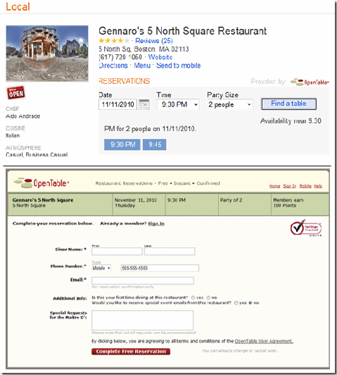
Our new Interior Views help you decide if a restaurant is the right place to go…so it only makes sense to better help you get a reservation. When you go to a local details page for one of the 15,000 restaurants signed up with OpenTable, you can now search for available reservations directly in Bing. Enter in the date, time, and party size and Bing pulls up what’s open. Click on a time you want and you’re brought to the page to finalize your reservation. Simple. To recap:

· Reservations through OpenTable are now available right on the local details pages.
· Every restaurant that is an OpenTable customer will have this functionality.
· Bing Local makes planning a night out easier and faster so you can spend more time on the important things (like what you’re going to eat once you get there!)

Real-Time Transit & Streetside for Mobile

At Bing, we want to help our users answer a lot of questions. Two of these questions are: “When is my bus really coming?” and “What’s the place I’m walking to look like?” With Real-Time Transit and Streetside added to Bing Maps on mobile, we can check those two questions off the list.

Real-time Transit for Bing Mobile on the iPhone adds up-to-the-minute data for Seattle, Boston, and San Francisco transit agencies. In one release cycle, Bing added transit routing and is now the first search engine to offer real-time transit information.

Streetside on Bing Mobile gives you the street-level imagery currently available on the desktop but with a few “enhancements.” If you pinch the screen to zoom out, the Streetside imagery will be stitched together so you can flick your finger and easily pan through streets. Also, the names of local businesses in the current street-level view appear under their respective buildings so you can learn more about what you’re seeing.

Below is a video to see Real-time Transit in action, but to learn more about the entire Bing Mobile release and see all the features and screenshots, head to the Bing Mobile Post.