Precision Gardening

After living in an apartment complex for three months we recently moved to a house of our own. What the Bureau of Land management does for the entire United States, I do for my 9000 square feet of garden. Working in the field of GIS I thought about applying some of the techniques available to help me managing my domain.

We thought that we paid a lot of attention to our gardens in the Netherlands. After all, we are the tulip country of the world. How surprised we were to see the amount of attention that is put to gardening here in Redlands. Our newly acquired garden has a built-in irrigation system and this is not a rare luxury, but can be found all over town. Of course, when considering that we live in a cultivated piece of the dessert, it is only a bare necessity to treat the garden properly.

But what is properly? It is not uncommon to see small streams of water flowing down the road, indicating that some garden is being soaked instead of watered. The questions of life for the new homeowner are when to water the grass and how much does it need, or does it need feeding? And what about the roof? I realized that these questions are the urban echo of farmers across the globe wondering how to improve the yield of their land while controlling the cost.

One of the big differences is of course scale. To distinguish different parts of a garden as opposed to multi-acre fields, the resolution of the information needs to be better than one meter I would say. The high-resolution satellites that are becoming more and more available are rapidly solving this.

Another point is that in our garden we try to keep the grass short instead of having it grow like a field of corn. I am not aiming at optimizing yield. My concern is to apply enough water to avoid my grass to dry out without drowning it. I would like a thermostat-like system that tells me when and how much to water the lawn.

Farmers who expect a high increase in yield when applying precision farming are prepared to invest. For us homeowners the benefits mainly consist of saving money on water. This means that if the precision gardening business is to be viable, it should be a low-cost service. Luckily we have one very strong point in favor over farmers. Homeowners come in large numbers. The same principles should apply as with cable television or utilities. Having the cable company digging a cable to a single house would make it very expensive. Sharing cost with other users is the key to success.

The system I envision accounts for the amount of rain that has fallen over the past period, the seasons, the type of soil in the area and such. It should be possible to enter the type of grass is used in my garden. Satellite images are combined with weather forecasts and soil types in the area. These data come from different sources, but with technologies such as applied in the Geography Network, this should not present a problem. A future generation of the system may even support searching for more accurate data that feeds in the model (local weather reports for example) or for competing models that promise minimal water usage while giving a nice green lawn.

Think of the size of the market, if one could sell this type of geographic services to every garden-owning family in the world. Being able to log in to www.precisiongardening.com and to see my garden on screen with hints where to apply water and how much would not only be really cool, but could also help save some on the water bill. And saving water is only a natural thing to do in the dessert.

Appeared in GeoInformatics Magazine (www.geoinformatics.com) in April/May 2002
Imagery Update – Week of November 1st

The Google Earth and Maps Imagery team has just released another extensive batch of aeriel and satellite images for your enjoyment! In honor of the upcoming U.S. holiday Veterans Day (November 11th), we’ll take a look at a few military-themed museums.

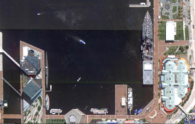
Let’s start with a wide-view of the naval ships on display at the Baltimore Maritime Museum in Baltimore, Maryland. Historic ships that you can zoom in on and see close up in Google Earth or Maps include the last sail-only warship USS Constellation (lower left); the submarine USS Torsk (upper left) which sunk the last enemy ship in World War II; and the cutter USCGC Taney (upper right), the last ship still floating that fought during the Pearl Harbor attack.

Baltimore Maritime Museum in Baltimore, MD

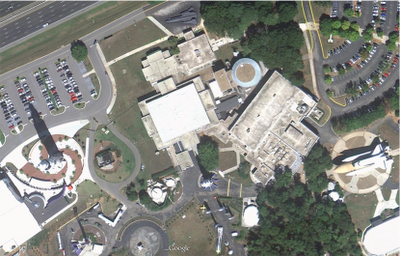
Now that we’ve got our sea legs, let move sub-orbital and beyond at the U.S. Space and Rocket Center in Huntsville, Alabama. Here we can see a restored Saturn V-1 “moon shot” test vehicle and the A-12 Oxcart “Blackbird” spy plane.

U.S. Space and Rocket Center in Huntsville, AL

These are just a few examples of the many museums around the globe that are included in our latest imagery batch.

High Resolution Aerial Updates:
USA: Baltimore, Cedar Rapids, Huntsville, Long Island, Redding, Springfield (IL), St. Joseph (MO)
Austria: Schladming
Finland: Pori
Ireland: Athlone, Drogheda, Dundalk, Enniscorthy, Galway, Limerick, Monaghan, Tralee, Waterford,
Spain: Vasco

Countries receiving High Resolution Satellite Updates:
Albania, Algeria, American Samoa, Angola, Argentina, Armenia, Australia, Austria, Azerbaijan, Bangladesh, Belarus, Benin, Bolivia, Botswana, Brazil, Bulgaria, Burkina Faso, Burundi, Cameroon, Canada, Central African Republic, Chad, Chile, China, Colombia, Costa Rica, Cuba, Côte d’Ivoire, Democratic People’s Republic of Korea, Democratic Republic of the Congo, Ecuador, Egypt, El Salvador, Equatorial Guinea, Eritrea, Ethiopia, Finland, Former Yugoslav Republic of Macedonia, France, Georgia, Germany, Ghana, Greece, Guatemala, Guinea, Guinea-Bissau, Guyana, Honduras, Hungary, India, Indonesia, Iran, Ireland, Kazakhstan, Kenya, Kyrgyzstan, Lesotho, Liberia, Libya, Madagascar, Malawi, Malaysia, Mali, Mauritania, Mauritius, Mexico, Moldova, Mongolia, Montenegro, Morocco, Mozambique, Myanmar, Namibia, Nepal, New Zealand, Nicaragua, Niger, Nigeria, Norway, Oman, Pakistan, Panama, Paraguay, People’s Republic of the Congo, Peru, Philippines, Poland, Portugal, Romania, Russia, Rwanda, Saudi Arabia, Senegal, Sierra Leone, Somalia, South Africa, Spain, Sudan, Suriname, Swaziland, Taiwan, Tajikistan, Tanzania, Thailand, The Bahamas, Togo, Tonga, Tunisia, Turkey, Turkmenistan, Uganda, Ukraine, United Arab Emirates, United Kingdom, United States, Uruguay, Uzbekistan, Venezuela, Vietnam, Yemen, Zambia, Zimbabwe

These updates are currently only available in Google Earth, but they’ll also be in Google Maps soon. To get a complete picture of where we updated imagery, download this KML for viewing in Google Earth.

New KMLs for Panoramio photos in Google Earth

Panoramio has just updated their network link KMLs that are used in Google Earth to make them faster and more useful. Not only is the link faster, but “The algorithm that is responsible for distribution and taking care of thumbnail overlaps has been improved as well and that is the reason you will now have a feeling of density that did not exist before, together with a better discoverability of the photos in the layer.

As you can see in the photo below, the new versions of the KML files show a lot more photos than before:

panoramio-kml.jpg

As they mention in their blog entry about this update, here is how you can download the various KML files:

1. Popular photos in Google Earth: http://www.panoramio.com/map/

(click on the link in the lower-left corner of the Site)

2. Popular photos in Google Earth (Including photos not selected for the Panoramio layer in Google Earth): http://www.panoramio.com/map/

(you need to select the box before downloading the file from the lower-left corner of the Site)

3. Recent Panoramio uploaded photos: http://www.panoramio.com/map/

(select the recent tab and then click on the link in the lower-left corner of the Site)

4. Photos from a specific tag: http://www.panoramio.com/tags

5. Your Photos: Go to your page http://www.panoramio.com/user/user_ID and click on the link that says “in Google Earth”

We’ve talked about Panoramio quite a lot over the past few years, and they get better with each update.

Have you uploaded many photos to them? Will you be adding more now that this feature has become even more useful?