Over the years, the
Google Earth Outreach team has seen hundreds of maps that nonprofits are using to change the world for the better. We’ve also talked to just as many nonprofits who have a great idea for a map they want to create, but don’t have people on their team with enough technical skills to create it.
Today, we’re excited to announce the Google Earth Outreach Developer Grants program, supporting selected projects from eligible nonprofit organizations that are using Google’s mapping technologies in novel, innovative ways to make the world a better place.
Through this program, non-profit organizations from all over the world will have an opportunity to receive up to $20,000 that will help turn their mapping ideas to support their causes into a reality. Numerous nonprofits have already used Google Earth to raise awareness about an issue or cause that demonstrate innovation and creativity. The US Holocaust Memorial Museum and partners created the Crisis in Darfur Google Earth layer, which utilized Google Earth’s high-resolution satellite imagery to document the burning of villages, destruction of communities and livelihoods as a result of the genocide in Sudan. The presentation of refugee stories and testimonials in a map visualization brought 26 times the usual number of visitors to the USHMM’s “How Can I Help?” section of the website.
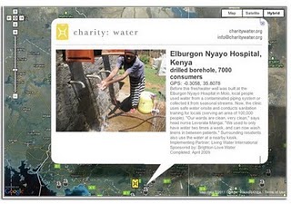
Charity:Water uses the Google Maps API to show donors precisely where the money they contributed was allocated. After donating, donors receive geographic coordinates to view the location of a well to which they’ve contributed, and they can also view pictures of people accessing clean drinking water as a result of their contribution.
Applications to the Google Earth Outreach Developer Grants program will be accepted until May 26, 2011. More details of the program, project requirements and eligibility can be found on the Google Earth Outreach Developer Grants page.
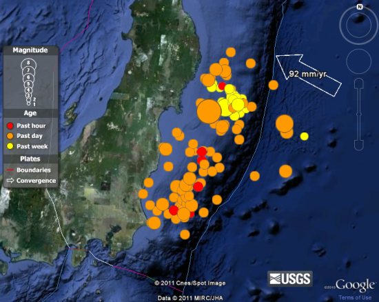
 , which uses the Google Earth plug-in to show real-time earthquake information world-wide.