Explore university campuses in 3D and StreetView


As part of the continual additions to Street View, Google has just added more university campuses around the world to the product, bringing the total number of Street View-able campuses to nearly 100.

Combine that with the fact that thousands of new 3D buildings are added to Google Earth each week, along with 3D trees in a growing number of cities, and you have some excellent tools at your disposal to help browse around your favorite college.

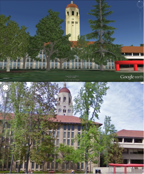
For example, below is Stanford University shown in Google Earth and Street View so you can compare the views:


stanford-comp.jpg 

Google has spotlighted a few other universities in a recent blog post and you can view the full list of Street View-enabled campuses on their site.

You can also view some extra goodies at a few schools (like the virtual campus at Northeastern University) and utilities such as Campus Bird help provide more geo context for hundreds of schools.

As good continues to add Street View at more schools, and schools continue to work on their 3D buildings, this kind of exploration will only get better!

Paul McCartney’s Wrigley Field show by using Google Earth


Paul McCartney is in the middle of his brief “On The Run” tour, performing in various North American stadiums to huge crowds.

In a few days (this Sunday and Monday) he’ll be playing in Chicago’s Wrigley Field, and concept3D has built a really neat tool to help show you what the view will look like from your seat.


paul-seats.jpg 

It reminds me a bit of Room77, which allows you to preview your hotel room in Google Earth. As Google Earth continues to become more realistic, especially with 3D buildings and trees, tools like these will likely become more common and more useful.

One of the best parts of this Wrigley/McCartney model is the drop-down menu in the KMZ file itself. If you expand (+) the folder once it’s loaded in your “Places” sidebar, you can click the section where you’ll be sitting and the camera will automatically fly around to show you what your view will look like from that section. You can get the KMZ file here, but be warned that it’s quite a large file at around 10MB.

If you don’t wish to load the full file, concept3d has created a short video to show you around the model:

We’ve shown you some of concept3d’s work in the past, including the excellent 3D Virtual Campus at Northeastern University. They’re a custom Google Earth modeling shop, and certainly a good one to contact if you need some 3D work done for a project.

Five Universities with great maps

Over the years we’ve shown you a variety of Universities around the world that are making great use of Google Earth and Google Maps, including 3D models at Bowling Green and Boston University, a 3D virtual campus at Northeastern, and a variety of great tools at the University of Exeter. The Google Geo Developers Blog recently took at five Universities that are making great use of geo tools, and it’s a great list.

Many of the schools they show are simply using 2D maps, but they do a great job with them, such as the University of Washington, shown here:

washington.jpg

The five featured schools are Northeastern University, the University of Washington, the University of Ottawa, the University of California – San Diego and the University of Notre Dame. Check out the full blog post for more info.

If you’re a college student, how does your school stack up?