The File Geodatabase API Is Available

So I guess there really is news at the Esri FedUC (was beginning to wonder if it was just more of the same from the last year). Esri has finally released their File Geodatabase API. Without having looked into it yet Esri says you can do the following:

  • Create, Open and Delete file geodatabases
  • Read the schema of the geodatabase
    • All content within a geodatabase can be opened for read access
  • Create schema for objects within the simple feature model
    • Tables
    • Point, Line, and Polygon feature classes
    • Feature datasets
    • Domains
    • Subtypes
  • Read the contents of datasets in a geodatabase
    • All dataset content within a geodatabase can be read
  • Insert, Delete and Edit the contents of simple datasets:
    • Tables
    • Point, Line, Polygon, Multipoint, and Multipatch feature classes
  • Perform attribute and (limited) spatial queries on datasets
    • Spatial queries will be limited to the envelope-intersects operator

A couple points here. First off there is no raster support. Second you are totally on your own here. You have total control over screwing up your geodatabases here. Some may want to continue using ArcObjects as it gives you some framework to work within. Lastly this is a C++ API, while I don’t see the need for .NET or Java “versions” feel free to continue complaining about Esri ignoring you below.

I still can’t believe they finally released this thing.
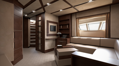
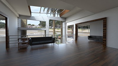
Photo-rendering with Shaderlight

If I had a nickel for every time someone asks me which renderer they should use with SketchUp, I’d have a fleet of helicopters perched on the turrets of my castle. One look at SketchUp’s Fan Photos page on Facebook is all you need to understand our community’s obsession with delicious photo-realism. There are piles of fantastic rendering tools to choose from, and more become available all the time. Happily, most of them have a “free mode” that you can use to try things out.

Shaderlight, an awfully-impressive (and relatively new) offering from ArtVPS, is one such rendering tool. Its interface is clean and straighforward, there’s a free version available and the video tutorials are easy to follow and comprehensive. It’s currently only available for Windows, but I’m told that a Mac version is in the works. Here are some tasty sample renderings to whet your appetite:

Boat interior rendering by Sully114

Rendering by Daniel Tal
Kitchen rendering by Eric Schimelpfenig
Villa interior rendering by Sully14

In the interest of fairness to all of our rendering friends, our plugins page lists some of the other tools you can investigate if photo-realism is your bag.

FME 2011 – Released

FME 2011 – Released

FME 2011 release today

“Probably the best Feature Manipulation Engine [FME] GIS/CAD conversion software you can get.”

FME 2011 - Released

FME 2011 release “story through some numbers”

Top Pick from Mapperz #osm data reader and writer!

  • 25,000: Approximate number of CPU hours spent on the automated testing of FME 2011
  • 8320: Number of automated tests run each weekend
  • 8304: Number of source code check-ins on the FME 2011 code tree
  • 6249: Number of automated tests run on each daily FME build
  • 2602: Number of documented development tasks closed during FME 2011
  • 1008: Number of in-person attendees at FME User Meetings during calendar 2010
  • 592: Number of unique customer requests resolved with FME 2011
  • 416: Number of transformers shipped with FME 2011
  • 265: Number of formats supported by FME 2011
  • 201: Number of builds of FME 2011 that have been made (so far)
  • 20: Number of hours of CPU a complete test run takes on the fastest platform
  • 15: Number of months that we’ve been actively developing on FME 2011
  • 11: Average percentage speedup of FME 2011 vs. FME 2010 across all tests which run for more than 7 seconds
  • 5: Number of platforms the above tests are run on
  • 1: FME 2011 Gold master DVD shipped off to the press

“All these numbers add up to what we believe is the highest quality, most powerful, and most usable FME ever.”

Driven by User Feedback
FME have been able to implement so many excellent suggestions from users (many of which we received during our user meetings throughout the year) – including:

    a) Ability to work with LiDAR and point cloud data
    b) Templates to get you started down the right path
    c) Convenient SQL Querying
    d) Scheduling and a REST API for FME Server
    e) A greatly expanded set of Tester predicates
    f) Inline data inspection – “workspace debugging” if you like. No more waiting for a translation to finish to see what the results are
    g) “Styler” transformers for customizing CAD output
    h) More powerful XML support
    i) Support for cloud options (Windows Azure, Google Spreadsheet, etc)

http://blog.safe.com/2011/01/fme-2011-a-retrospective-on-todays-release/