Precision Gardening

After living in an apartment complex for three months we recently moved to a house of our own. What the Bureau of Land management does for the entire United States, I do for my 9000 square feet of garden. Working in the field of GIS I thought about applying some of the techniques available to help me managing my domain.

We thought that we paid a lot of attention to our gardens in the Netherlands. After all, we are the tulip country of the world. How surprised we were to see the amount of attention that is put to gardening here in Redlands. Our newly acquired garden has a built-in irrigation system and this is not a rare luxury, but can be found all over town. Of course, when considering that we live in a cultivated piece of the dessert, it is only a bare necessity to treat the garden properly.

But what is properly? It is not uncommon to see small streams of water flowing down the road, indicating that some garden is being soaked instead of watered. The questions of life for the new homeowner are when to water the grass and how much does it need, or does it need feeding? And what about the roof? I realized that these questions are the urban echo of farmers across the globe wondering how to improve the yield of their land while controlling the cost.

One of the big differences is of course scale. To distinguish different parts of a garden as opposed to multi-acre fields, the resolution of the information needs to be better than one meter I would say. The high-resolution satellites that are becoming more and more available are rapidly solving this.

Another point is that in our garden we try to keep the grass short instead of having it grow like a field of corn. I am not aiming at optimizing yield. My concern is to apply enough water to avoid my grass to dry out without drowning it. I would like a thermostat-like system that tells me when and how much to water the lawn.

Farmers who expect a high increase in yield when applying precision farming are prepared to invest. For us homeowners the benefits mainly consist of saving money on water. This means that if the precision gardening business is to be viable, it should be a low-cost service. Luckily we have one very strong point in favor over farmers. Homeowners come in large numbers. The same principles should apply as with cable television or utilities. Having the cable company digging a cable to a single house would make it very expensive. Sharing cost with other users is the key to success.

The system I envision accounts for the amount of rain that has fallen over the past period, the seasons, the type of soil in the area and such. It should be possible to enter the type of grass is used in my garden. Satellite images are combined with weather forecasts and soil types in the area. These data come from different sources, but with technologies such as applied in the Geography Network, this should not present a problem. A future generation of the system may even support searching for more accurate data that feeds in the model (local weather reports for example) or for competing models that promise minimal water usage while giving a nice green lawn.

Think of the size of the market, if one could sell this type of geographic services to every garden-owning family in the world. Being able to log in to www.precisiongardening.com and to see my garden on screen with hints where to apply water and how much would not only be really cool, but could also help save some on the water bill. And saving water is only a natural thing to do in the dessert.

Appeared in GeoInformatics Magazine (www.geoinformatics.com) in April/May 2002
A Place for everything, and everything in its Place

If someone asked you where you are right now, how would you answer? Would you say that you are at home, or at work? Maybe you are in a foreign country, in the park, or at your favourite coffee shop. These are just a few of the many places by which we navigate through our daily lives. Maps applications may see the world in terms of latitudes and longitudes, but we think in terms of ‘Places’.

In September of last year Google launched Place Pages on Google Maps. Each Place Page consolidates together everything we know about a single Place, be it a business, point of interest, or geographical feature such as a city or neighbourhood. We believe that this unified concept of Places more accurately reflects the way that Maps users see the world, and are working to bring an awareness of Places to the Google Maps API. At Google I/O today we offered a preview of the first Place related features that that are coming to the Google Maps API in the near future.

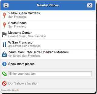
The Nearby Places widget is a user interface element that will launch in the Google Maps API v3. It combines the W3C Geolocation API with location based Place search to present the user with a list of Places in their immediate vicinity. The user can select a Place which the Maps API application can use as a check-in, or to tag content supplied by the user about that place. The application can also obtain more detailed information about the Place, such as the address, telephone number, and Place Page URL.

The Nearby Places widget is built on top of the Places Web Service, a new addition to the family of Google Maps API Web Services. The Places Web service offers search for nearby places to native mobile applications through an XML/JSON REST interface. In order for us to manage demand and ensure that the Places Web Service is used appropriately, applications will be required to authenticate their requests. If you are interested in using the service, check out the Places Web Service documentation which outlines the usage guidelines and application process. We expect to begin processing applications when the service launches in July.

We are also very excited to be working with Booyah, developers of the hugely popular MyTown iPhone application. The broad international coverage and superior performance of the Places Web Service made it the logical choice to serve the growing community of over two million active MyTown users. We were delighted to invite David Wang, Vice President of Business Development at Booyah, to speak at Google I/O about the ways in which they are integrating the Places Web Service into the MyTown application.

The Nearby Places widget and Places Web Service are our first steps towards tightly integrated and powerful support for discovering and understanding Places using the Google Maps API. Keep an eye on this blog for more information about the availability of these services, and other Place related launches in future.

Greetings from Santa Kurara, Kariforunia

Hello from the Unicode Conference in Santa Clara, California, where the Maps Transliteration team is giving a talk about ICU-based transliteration. Transliterating this originally Spanish city name to Japanese, we get サンタ・クララ, which (when morphed back to the Latin writing system) becomes “Santa Kurara.”

Machine Transliteration is an active area of research (slides), which means it can be rather challenging in general. Typically, transliteration emulates the pronunciation, but sometimes it also preserves some aspects of the original written spelling. We created transliteration modules with the open-source ICU library for languages that have highly regular spelling; if you’re using Google Maps in Japanese, Russian or Chinese, you can see how we use it to display labels in both the local language and your own:


Today, we’re announcing the contribution of our ICU transliteration rules for Czech, Italian, Japanese, Korean, Mandarin, Polish, Romanian, Russian, Slovak and Spanish to the Unicode Common Locale Data Repository. (For languages with very irregular spelling, like English, we supplement ICU with some more advanced techniques.) If you would like to try writing rules for your own language, have a look at the instructions in the ICU user guide.

アスタ・ラ・ビスタ — “Asuta ra bisuta,” from sunny “Kariforunia!”