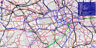
Openptmap shows public transport lines. Depending on the zoom level, bus and tram lines are displayed in addition to the railway lines….
OpenPT Maps – London, UK with All available Public Transport Data overlaid.
Existing Features:
- Interactive Timetable function (timetables cover Europe)
- Zoom levels 4 – 17 (Large Scale Zooms)
- Line numbers
However, there are some useful new features also:
- Public transport network grid without background available
- Optional backgrounds: Mapnik and CycleMap
- Different background luminance (pale modes)
- Railway timetable on demand with mouse click (small squares)
- Aerial lifts are displayed
Openptmap editors can be useful in these situations:
- You added a new pt line to OSM and want to review it
- You want to get an overview of the Public Transport network without interfering background
- To find out the departure times of buses/trains at nearby stations
