Yahoo! Maps APIs Service Closure – Due 13th September 2011

Yahoo! Maps APIs Service Closure – Due 13th September 2011

(And suggest working/moving to Nokia Maps and Nokia Maps API)

As part of Yahoo!’s commitment to creating deeply personal digital experiences, we have been reprioritizing our current portfolio of mapping products to refocus on a great consumer Mapping and Local Search experience. After careful consideration, Yahoo! will no longer support the below Maps APIs as of Sept 13, 2011. However, we are continuing to invest in our core maps offering at Yahoo! and later this year will announce more details of our strategic partnership with Nokia, so stay tuned!

We will continue to support a number of location APIs and encourage you to use our Placefinder API for geocoding, our Local Search API and Placemaker for geoparsing.

In the meantime, we have decided to close the following Maps APIs:

Supported Geo APIs and alternative services
Yahoo will continue to support a number of location APIs. We encourage you to use our Placefinder API for geocoding. The Local Search API remains available and Placemaker is still available for geoparsing.

Developers who wish to implement maps, routing and traffic into their web pages may use third-party developer networks for mapping services. We suggest using maps from our partner Nokia. Please go to api.maps.ovi.com/ for more information.

Q&A

Q: On what exact date will the Yahoo! Maps APIs be shut down?
A: Yahoo! will no longer offer the Maps API service as of September 13, 2011.

Q: Why is Yahoo! removing the Maps APIs service?
A: In order to focus on our core strengths and deliver new innovations, we are reprioritizing our portfolio of products and services – increasing investment in some areas while scaling back in others. This will allow us to continue improving the Yahoo! Maps and Local Search experience and allow us to focus on providing best-in-class digital media, content and communications experiences.

Q: What Maps APIs will remain available for developers?
A: Placefinder, Placemaker and Local Search will continue to be supported.

Q: What other resources are available to developers wishing to use maps?
A: Developers who wish to implement maps, routing and traffic into their web pages may use third-party developer networks for services. We suggest using maps from our partner Nokia. Please go to api.maps.ovi.com/ for more information.

Q: What is the status of Nokia integration with Yahoo! maps and navigation services?
A: This work is in-progress and we plan to have something to announce later this year.”
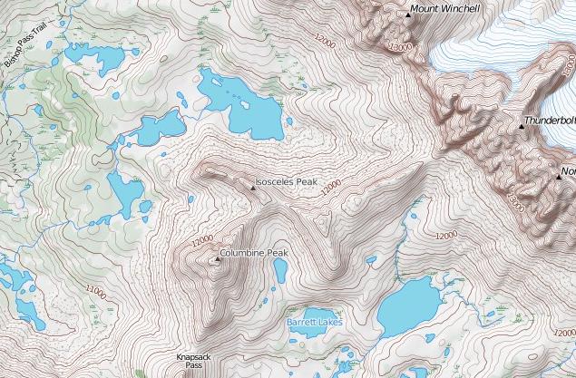
Contour SPS Maps

Closed Contour SPS Maps

SPS (Sierra Peaks Section)

Closed Contour SPS Maps

Version 2 of the SPS Map by Closed Contours

New Specs:

  • Whiter glaciers/permanent snow with blue contour lines.
  • Change forest color depending on density (only in Yosemite and Sequoia/King’s Canyon NP so far). I also mentioned this in a previous post.
  • Non-SPS peak names. Discussed earlier as well.
  • Pass names.
  • Trail names, mostly in the NPs.
  • Removed many bogus ‘lakes’ which were actually mis-characterized permanent snow.
  • Added styling for scree, talus, and meadow/marshes.
  • Changed font for SPS peaks to slightly larger, darker, and italic to set them apart from non-SPS peaks.
  • Not a tile change, but added UTM coordinate display in lower right.


The SPS Maps have 248 peaks in the Sierra Nevada range of eastern California (plus Mount Rose in Nevada). The list is maintained by the Sierra Peaks Section, Angeles Chapter, Sierra Club. The map was designed to encompass all of the peaks on the list with a small buffer around them.

Cartography

Using a Transverse Mercator projection with a central meridian of 120° W, origin latitude of 0°, scale factor of 0.9996, WGS84 ellipsoid, and no false easting or northing. This projection was chosen as a compromise between UTM zones 10 and 11 which unfortunately split the Sierra Nevada vertically right through Lake Tahoe. Here’s the proj.4 string for the projection:

+proj=tmerc +lon_0=120w +k=0.9996 +ellps=WGS84
Data

Data sources:
DEMs are from the USGS NED program. (To generate hill-shade and contours.)
Road data are from TIGER.
Hydrology data are from the USGS NHD program.
Trails data are from the NPS and Forest Service.
Land cover data is from NPS and FRAP.
Buildings are from NPS and Mono County.

Map
http://www.closedcontour.com/

More information
http://blog.closedcontour.com/sps-map/

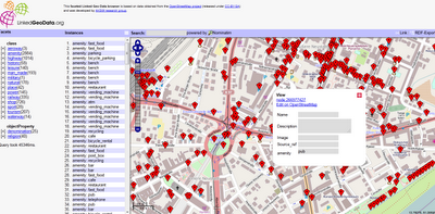
The Open Street Map LinkedGeoData

Open Street Map Linked GeoData (RDF)

Making geographical data more discoverable and accessible:
Open Street Map Linked GeoData

LinkedGeoData is an effort to add a spatial dimension to the Web of Data / Semantic Web. LinkedGeoData uses the information collected by the OpenStreetMap project and makes it available as an RDF knowledge base according to the Linked Data principles. It interlinks this data with other knowledge bases in the Linking Open Data initiative.

The Linked Geo Data Knowledge Base

“In order to employ the Web as a medium for data and information integration, comprehensive datasets and vocabularies are required as they enable the disambiguation and alignment of other data and information. Many real-life information integration and aggregation tasks are impossible without comprehensive background knowledge related to spatial features of the ways, structures and landscapes surrounding us.

LinkedGeoData uses the comprehensive OpenStreetMap spatial data collection to create a large spatial knowledge base. It currently consists of information about approx. 350 million nodes and 30 million ways and the resulting RDF data comprises approximately 2 billion triples. The data is available according to the Linked Data principles and interlinked with DBpedia.

Accessing the data:

The following interfaces exist for online access:

  • Rest Api: provides basic access to a database with a full Open Street Map (OSM) planet file loaded.
  • Sparql Endpoints: enable queries on databases with a reduced (but hopefully for many applications relevant) subset of the whole data loaded. The Sparql Endpoints come in two flavours:
    • Static: Contains the data extracted from a OSM planet file of a certain date
    • Live: Initially a copy of the static version that is then synchronized with the minutely updates from OSM.


Example Link
http://browser.linkedgeodata.org/?lat=51.063657689874&lon=13.750735172091&zoom=16&prop=amenity&val=

Access to the Data
http://linkedgeodata.org/OnlineAccess