Google Maps Becomes Bing Maps

Goog Map


Justin O’Beirne of Latitude41, who created the awesome Examples of Styled Maps Using Google Maps API Version 3, has been at it again and has now created Additional Examples of Styled Maps Using Google Maps API V3. The new styles include a few examples mimicking the styles of other online map providers.

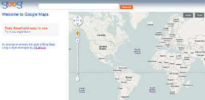
I’ve used Justin’s example of copying the style of Bing Maps to try and reproduce the Bing Maps home page. It would be possible to make this look more authentic by emulating the Bing Maps zoom control using the Custom Controls function in the Google Maps API. However I’ve spent far too many hours on this already – so it’s not going to happen.

_____________

Nice updates to the Tuvalu Visualization Project

A while back, we told you about the

Tuvalu Visualization Project

which is a visualization that was put together to “present the real situation of Tuvalu, to improve the interest in Tuvalu, and to receive feedback from all over the world.”

tuvalu1.jpg

At that time, it was simply a KMZ file that you could download. Now they’ve added a version using the Google Earth Plug-in and it has some nice new features.

Along with now being accessible from your browser, one of the new features is that you can send a message to a Tuvaluan from one of the pop-up balloons that appear when you click on someone. Your message will be delivered to that person via email, and a blue line will be drawn on the globe from your location to theirs. They’re using the MaxMind Geolocation database to determine your location based on your IP address. It looks pretty cool:
tuvalu2.jpg

To try it for yourself, simply head over here and give it a shot.

Leicester City Traffic on Google Maps

Leicester Live Traffic & Travel Map


Leicester City Council in the UK have produced a Google Map to provide live traffic information for the city of Leicester and surrounding towns.

Using the Incidents and Roadworks tab it it is possible to view all the local hold-ups affecting traffic. It is also possible to view all of the city’s traffic cams directly from the map to view current road conditions. The map also contains information on all the city’s car parks, including how many parking spaces are currently available.

Public transport users can use the map to find the nearest bus stops and to view live departure times of buses (where available).

All-in-all the map provides a very comprehensive service for Leicester drivers and bus users but the map does have one glaring omission. The Leicester Live Traffic and Travel Map doesn’t include the Google Maps API Traffic Layer.

_____________