The work of jgago93 in Chile

Last fall, Google added the cities of Santiago and Valparaiso to their Building Maker tool. The city was already partially modeled, thanks to the work of users such as gananunez, GecKo StuDio, Sergio and jgago93.

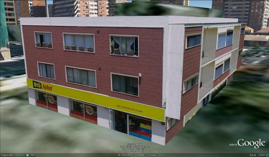
While all of them are continuing to do great work, I want to focus a bit on jgago93. Prior to Building Maker arriving in Chile, he had done a variety of excellent models in SketchUp. Below is an example of a convenience store (and apartments?) that he created. Notice the excellent textures he used, including the 3d railings on the right side of the building:

jgago1.jpg

Since Building Maker is now available over there, he’s made excellent use of it. Many of his recent models were created with Building Maker, and as of today he’s generated a total of 108 models, 74 of which are already included in Google Earth!

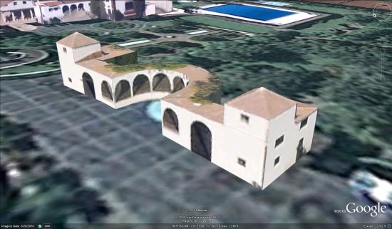
His Builder Maker models are quite well done, too. For example, notice the building below. While the textures are rather fuzzy (not much he can do about that), he obviously spent a good bit of time to make sure the architecture was accurate:

jgago2.jpg

Because of Building Maker and 3D modelers like the people we mentioned above, these cities (particularly Santiago) are becoming quite filled with 3D models are are looking excellent. Hopefully Google will bring StreetView to that area soon, as that will result in even better-looking models.

Have you done much with Building Maker lately? Leave a comment and show off some of your best work!

The “City of Love,” now in 3D

To foreigners, Paris is the “city of love.” To Parisians, it’s the “city of lights” (La Ville-Lumière). Today, Paris is the “city in 3D.”

Sunrise in Paris

Often considered one of the top destinations for world travelers, Paris is known for landmarks like the Notre Dame Cathedral and the Arc de Triomphe, world-famous museums like the Louvre and the Musée d’Orsay, and hundreds of little bistros with French pastries so good they make your heart pop (literally and figuratively). Now all of these sites – and the many, many others that make Paris special – are available to tour in 3D in Google Earth.

With Google Earth’s “3D Buildings” layer turned on (or by using the Google Earth plug-in for Google Maps) you can wander the streets of the Montmartre district made famous by artists like Picasso, Van Gogh and Dalí from your living room. You can also see the Sacré-Cœur Basilica without having to climb the 237 steps to get there. Instead of waiting in line to see the view from the Eiffel tower, fly straight to the top in Google Earth and get a 360-degree view of Paris. Round out your tour by taking a peek at the Centre Pompidou, which turned the architectural world upside down (or perhaps inside out?) with its exposed skeleton and brightly colored building utilities.

Whether you’re an armchair tourist or planning your next vacation to France, take some time to tour the streets of the French capital and see the historic sites; after all, many of them were created by modelers just like you.

If you’d like to get involved in modeling your town (or any other location), we have several tools to get you started. With Google Building Maker, you can create and contribute a building in as little as 10 minutes. And if you’d like to refine your building, bring it into Google SketchUp for fine-tuning.

Happy touring!

Amazing 3D Mapping Goes Indoors

A team of researchers and students at UC Berkeley have developed a “laser backback” that produces fascinating 3-D models of the inside of a building.

“The idea is, you wear the backpack, you walk inside the building, you’re done,” says Prof. Avideh Zakhor. “Push a button, and out comes this model.”

Four cameras snap photos simultaneously, while a set of lasers and positional scanners do the rest. The resulting model is textured with each photograph, providing an unprecedented 3-D map of the inside of each building. As the video points out, the human wearer enables the mapping unit to explore in caves, up stairwells and throughout other areas that a robot simply couldn’t travel.

The backpack might herald the next step in online research–even for simple questions like “How fancy is that restaurant?” or “How deep is that cave?”

“Every location, indoors and outdoors, will eventually be mapped,” Zakhor said. “And we’ll have it all online. Without even going anywhere, you can see what [every] interior looks like.”