The new 3D cities on Google Earth for Android

Explorers of the world, rejoice! There is now a new way to explore the world, right from the palm of your hand. Gone are the days when the only way to get a bird’s eye, 3D view of your favorite metropolitan area was from the window of a penthouse apartment or helicopter. Now you can soar above your favorite cities in 3D, with Google Earth for mobile.


New 3D Imagery

We recently shared a preview of this striking new 3D imagery and starting today, you can take flight yourself with our latest version of Google Earth for Android. An updated version of Google Earth for iOS will be also be available soon.


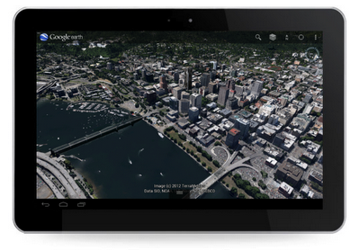
New 3D imagery of Portland, Oregon

Creating this comprehensive 3D experience is possible due to advanced image processing. Using 45-degree aerial imagery, we’re able to automatically recreate entire metropolitan areas in 3D. This means every building (not just the famous landmarks), the terrain, and any surrounding landscape of trees are included to provide a much more accurate and realistic experience.


Get started today by taking a virtual flight over one of our initial 3D imagery cities: Boulder, Boston, Santa Cruz, San Diego, Los Angeles, Long Beach, San Antonio, Charlotte, Tucson, Lawrence, Portland, Tampa, Rome or the San Francisco Bay Area (including the Peninsula and East Bay). We’ll continue to release new 3D imagery for places around the world over the coming months; by the end of the year, we aim to have new 3D coverage for metropolitan areas with a combined population of 300 million people.

Tour Guide

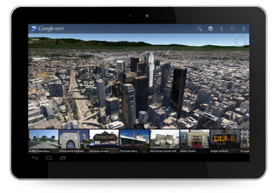
Not sure where to begin? Let the new tour guide help show you the way. We’ve put together short tours of thousands of famous places and historical sites across the globe so it’s easier than ever to discover amazing places. Just pull up the tab at the bottom of the screen to open the tour guide. Each image highlights a tours or place of interest in the area you are looking. Click on an item and you will be flown there. As you fly in and around the sites, snippets from Wikipedia provide additional information about the location. It’s like having a local expert right beside you!


Tour guide showing top destinations around Los Angeles.

We hope this more accurate, comprehensive and realistic 3D representation of the Earth brings out the inner explorer in you. Whether you are visiting familiar grounds or venturing out into the world, Google Earth is there to show you the way.
Four New Bing Maps V7 Modules

In September of 2011 Bing started the Bing Maps v7 Module CodePlex Project. The purpose of this project is to create a single place where developers can find and share useful modules that expand the functionality of the Bing Maps V7 API. Currently, there have been 10 modules submitted to the project. With a number of new modules in development, it’s safe to say that this project is definitely worth looking into. Today I would like to highlight the four newest modules added to this project.

Point Based Clustering Module

Download here

Bing created this module based on feedback received around the Client Side Clustering Module that  created some time ago. The older client side clustering module uses a grid based algorithm which is fast, but requires re-clustering the data every time the map moved. This allows for 5000+ pushpins to be clustered in a fraction of a second but often results in pushpins jumping around the map as you pan. The point based algorithm prevents pushpins from overlapping and jumping around by only clustering the data when the zoom level changes. Additionally this module keeps track of clustered information for each zoom level, making the algorithm faster the more you use it. This improved UI experience does affect performance and as such this algorithm is recommended for 2000 or less pushpins. Interested in reading more about how this algorithm was created? Check out this blog post.

GPX Parser

Download here

Bing created this module due to a number of requests that had received for such a module. This module allows you to easily pass in a URL to a GPX file and have it parsed into an EntityCollection which you can then render on Bing Maps. GPX is a type of XML file that is commonly used by GPS devices. It can be used to describe waypoints, tracks, and routes. Majority of the XML tags for V1 and V1.1 of the GPX schema are supported and all data is stored in a Metadata property, which is added to each entity.

Route Optimization – RouteSavvy Module

Download here

This module was created by OnTerra Systems, a Bing Maps Partner.

In today’s economy, it is more important than ever that companies optimize and manage their supply chains more efficiently. Given today’s fuel costs, product delivery with high quality of service and short delay times is paramount. Distribution accounts for a large proportion of the overall operational costs of a producer. Hence, effective and efficient management of transportation and distribution of goods are becoming increasingly important.

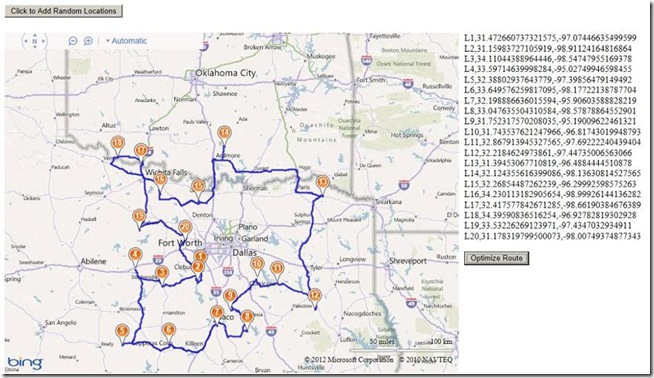
One of the key problems in this process is the optimization of delivery routes to customers. This problem is known as the “Travelling Salesman Problem” (TSP). RouteSavvy is a web service that helps solve this problem.

RouteSavvy is a simple but powerful tool that can take anywhere from 3 or 4 locations to hundreds of locations. It reorders them based on whether you’d like to visit them in a “round-trip” OR as a one-way trip, with the last stop chosen either by you or by the software (whichever is preferred).

Web developers can now easily integrate the RouteSavvy API into their web application by adding the RouteSavvy Map Module. The map module uses Ajax to call the RouteSavvy web service to optimize a given set of locations.

Here is a screen shot of a set random location optimized for a round trip:

Mini-Map Module

Download here

This module was created by OnTerra Systems, a Bing Maps Partner.

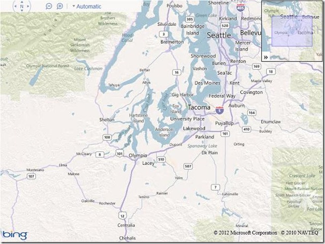
The Bing Maps Ajax v7 control doesn’t include support for adding a Mini-Map. The Mini-Map module adds a small map at the right corner of the parent map that’s collapsible and shows the extents covered by the current map. This module adds a mini map at the top right corner of the screen. Mini-map view helps to give a zoomed out overview of your location. Here is a screen shot of the implemented Mini-Map module:

I hope you find these new modules useful!

Google Earth: High-resolution imagery in Antarctica

As Google has continually improved the quality of their imagery across the globe, one area always seemed to stay low-res — Antarctica. Thanks to the help of the Polar Geospatial Center (PCG), that’s beginning to change.

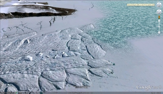
A great example of that is the Mackay Glacier Tongue, located in Granite Harbor, seen here:

mackay.jpg

You can see it for yourself, as shown in the article, using this KML file.

So far, the PGC has helped Google update nearly 1,000,000 square kilometers, with another 275,000 square kilometers added every three months. While it will take a while to get the entire continent updated (more than 14,000,000 sq km), they’re certainly making great progress.

Along with updating the quality of the imagery, they’re also working to improve the accuracy of the location of the imagery. The PGC’s Paul Morin will be heading down to the Antarctic Peninsula soon to help improve the imagery from being off by as much as 30 meters to being accurate within a single meter.

The full article at The Antarctic Sun is quite interesting and well worth your time to read. We all enjoy the constantly improving imagery quality in Google Earth, and the PGC is just one of many companies working with Google to help move things forward.

(via @OgleEarth)