Great tools for information about the solar eclipse


Over the next few weeks, the earth will be seeing a series of unique celestial events. Tomorrow many of us we will be able to see a a solar eclipse, June 4 will feature a lunar eclipse, and June 6 is the Transit of Venus. As you might expect, there are great Google Earth tools to help you make the most of all three events.

For the solar eclipse, the eclipse viewer from HeyWhatsThat.com is a great way to see where the best locations for the viewing the eclipse are located.


eclipse.jpg 

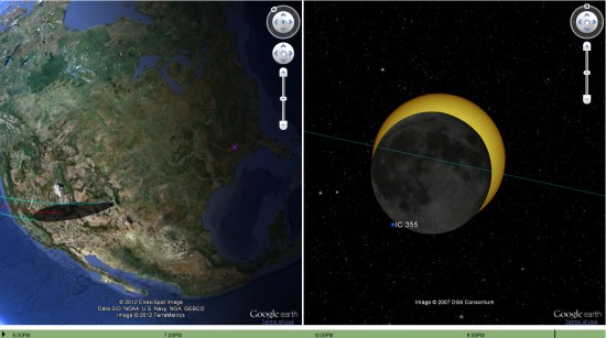
You can use the dropdown box in the lower right corner of the site to view other simulations, both past and future. You can learn more about the features available on their site by reading this text file.

Another great resource for this eclipse is Xavier Jubier’s map.


xavier.jpg 

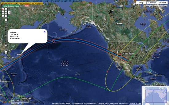
In addition to this eclipse, he has an extensive collection of data from other eclipses from 1961 through 2039 available to view.


Sharing Rich Content From Your Android Apps, to Google+ and Beyond

Many developers have been using Android’s share intent to help their users share content with others, directly from their apps. With the recently-launched ShareCompat library, you can now help your users share rich content with their friends (like images and videos) more easily, and the items they share include attribution to your app. All you need to do is add a few lines of code!

I’ll walk through a few examples that use Google+ as the application handler, but of course, these share intent improvements can work for any service. Popular apps like Foodspotting, Pulse News, and Shazam are already using ShareCompat to help users share rich content with their Google+ circles. You can check out this photo album to see how they are all taking advantage of the new library.

Creating the Share Intent

If you’d like users to be able to share text from your app, start by building the following intent:

Intent shareIntent = ShareCompat.IntentBuilder.from(ShareActivity.this)
   .setText("This site has lots of great information about Android!
      http://www.android.com")
   .setType("text/plain")
   .getIntent()
   .setPackage("com.google.android.apps.plus");

startActivity(shareIntent);

Here, I passed text and a URL to the setText method, and I used the setType method to identify the content as “text/plain.” The intent builder can then pass this information to the application that’s doing the sharing. Additionally, I used the setPackage method to specify the application that I want to handle it. In this case, the Google+ application is specified.

The Google+ share box with pre-populated text and link snippet.


The great new model of Saint Basil’s Cathedral

We’ve shown you work from 3D modeler ‘PeterG’ quite a few times here on Google Earth Blog. He built one of the first great 3D interiors that we saw, some nice 3D tours of Mount Urgull, and quite a few other models.

His latest work is the remodeling of Saint Basil’s Cathedral in Red Square, Moscow, Russia. It’s a stunning model that you need to see to believe.

basil.jpg

To go check it out for yourself, you can fly there by using this KML file. Be sure to have the [3D Buildings] layer turned on to view the building.

The Arctic Tern and the Sea Grapes


Last fall we showed you a great file from the people at Encyclopedia of Life that tracked Bluefin Tuna across the Atlantic. They’re back with a few new files that show how a type of sea algae (known as “sea grapes”) and Arctic Terns travel across the world as part of their annual migrations.


tern.jpg 

Ari Daniel Shapiro has worked with others, including Marie Studer and Eduardo Garcia Milagros, to put together some remarkable new tours. Ari’s background is in radio, so the audio narrative on the tours is excellent. Combine that with the images, video and Google Earth content and you’ve got a very engrossing and educational result.

The tours are available below, both in KMZ format for you to enjoy:

Sea Grapes Tour | KMZ


Arctic Tern Tour | KMZ


For more, you can view all of their tours on the Encyclopedia of Life site.

Google Earth: The city lights


The “Earth at Night” layer remains a very unique way to view the earth. Captured on the “dark side” of the planet, depending on the time of day, the images are a striking visual of the more urbanized areas of the planet.


lights.jpg 

However, the images were not easy to capture. For years, astronauts would try to capture the bright lights and only have blurry photographs to show for it, as the earth travels beneath them at 4.4 miles/second.

In 2003, Don Pettit developed an innovative system for capturing these images and he went on to capture over 2,500 photos, with thousands more captured in subsequent missions. You can read more about Don and his technique in this article at Air & Space Magazine.

To see the lights for yourself, simply click on the [Layers] in Google Earth, open [NASA], then [Earth City Lights] and click the button in there.. For the best results, disable your other layers and places to get a nice clean view of the earth. You should likely disable the atmosphere as well (under [View] –> [Atmosphere]), but I kind of like the glow it gives. It’s a neat effect.

A big thanks to Don for pioneering this amazing technique, and hopefully as time goes on this imagery will become even higher-quality and more striking.