Sharing Rich Content From Your Android Apps, to Google+ and Beyond

Many developers have been using Android’s share intent to help their users share content with others, directly from their apps. With the recently-launched ShareCompat library, you can now help your users share rich content with their friends (like images and videos) more easily, and the items they share include attribution to your app. All you need to do is add a few lines of code!

I’ll walk through a few examples that use Google+ as the application handler, but of course, these share intent improvements can work for any service. Popular apps like Foodspotting, Pulse News, and Shazam are already using ShareCompat to help users share rich content with their Google+ circles. You can check out this photo album to see how they are all taking advantage of the new library.

Creating the Share Intent

If you’d like users to be able to share text from your app, start by building the following intent:

Intent shareIntent = ShareCompat.IntentBuilder.from(ShareActivity.this)
   .setText("This site has lots of great information about Android!
      http://www.android.com")
   .setType("text/plain")
   .getIntent()
   .setPackage("com.google.android.apps.plus");

startActivity(shareIntent);

Here, I passed text and a URL to the setText method, and I used the setType method to identify the content as “text/plain.” The intent builder can then pass this information to the application that’s doing the sharing. Additionally, I used the setPackage method to specify the application that I want to handle it. In this case, the Google+ application is specified.

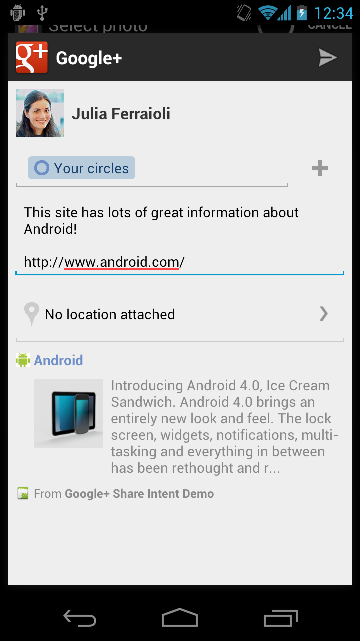
The Google+ share box with pre-populated text and link snippet.


The pyKML – a Python library for manipulating KML

pyKML is an open source Python library for generating, parsing, and modifying KML, the geo-spatial data language used by Google Earth, Google Maps and a number of other GIS platforms.

I was motivated to create pyKML because I frequently need to visualize large, and often complex, environmental datasets. While the KML language has a wide range of options for styling, annotating and interacting with geo-spatial and temporal data, most programs that generate KML don’t take full advantage of these rich features. I created the pyKML library to address this problem by providing easy, programmatic access to all KML elements.

pyKML facilitates working with large and complex KML documents by leveraging the use of basic programming constructs (looping, branching, etc.). In this regard pyKML is similar to libkml, Google’s open source C++ library, but takes advantage of the highly readable syntax of the Python programming language and the processing capabilities of the popular lxml Python library.

As a simple example, check out this Python script that loops through a text string (“Hello World!”) and uses pyKML to create a series of KML Placemarks. You can download the resulting KML document, and below is a screenshot of how it looks in Google Earth.

This is just a teaser of what pyKML can do. For more complex examples, check out the pyKML documentation and the project’s Google Code site that includes sample code for: generating KML from CSV data, creating KML Tours, and visualizing ephermeris data for Stonehenge (e.g., orientation of the sun on different dates). pyKML can even be used to create “slides” for presentations!

To get started, browse the project’s documentation, install the library, try it out, and let us know what you think!

via:  Tyler Erickson, Senior Research Scientist / Engineer, MTRI

Google Maps: Feel the Heat

We’ve been talking a lot recently around the Maps Developer Relations Team about heat maps. Heat maps use colors to represent the intensity of occurrence or certain values. Heat maps are a popular way to represent data. People often ask me how to create them themselves. So the other day when I ran across heatmap.js, with it’s nifty Google Maps API Heatmap Overlay, I thought it would be perfect to share with you. Heatmap.js uses HTML5 Canvas to render the heatmap on top of the map. Apparently, it’s in early release, so feel free to help the developer, Patrick Wied out with some patches. Here’s what it looks like:

On another note, we recently announced that several college campuses are now available in Google Street View, in areas outside roads. That data is now available to you in the Google Maps API. Here’s the Quad at Stanford:

Finally, if any of you are going to be at Strata, Chris Broadfoot and I will be presenting a workshop there March 1st called Beautiful Vectors. Check it out or just find us and say hi.

via: GoogleGeoDevelopers