The New Google Earth 6.2

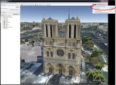
We’re taking bird’s eye view to a whole new level with the latest version of Google Earth, released today. With Google Earth 6.2, we’re bringing you the most beautiful Google Earth yet, with more seamless imagery and a new search interface. Additionally, we’ve introduced a feature that enables you to share an image from within Google Earth, so you can now simply and easily share your virtual adventures with family and friends on Google+.


A seamless globe

The Google Earth globe is made from a mosaic of satellite and aerial photographs taken on different dates and under different lighting and weather conditions. Because of this variance, views of the Earth from high altitude can sometimes appear patchy.

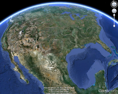
Today, we’re introducing a new way of rendering imagery that smoothes out this quilt of images. The end result is a beautiful new Earth-viewing experience that preserves the unique textures of the world’s most defining geographic landscapes—without the quilt effect. This change is being made on both mobile and desktop versions of Google Earth. While this change will appear on all versions of Google Earth, the 6.2 release provides the best viewing experience for this new data.

Grand Canyon before and after

Sri Lanka before and after

Share your explorations with Google+

Google Earth is a great way to virtually explore the globe, whether revisiting old haunts or checking out a future vacation spot. With the Google Earth 6.2 update, we’ve added the option to share a screenshot of your current view in Google Earth through Google+. If you’ve already upgraded to Google+, you can share images of the places you’ve virtually traveled to with your Circles, such as family, friends or your local hiking club. To try this new feature, simply sign in to your Google Account in the upper right hand corner of Google Earth and click “Share.” Images of mountains, oceans, deserts, 3D cities, your favorite pizza shop on Street View—you can now experience all these amazing places around the world with people on Google+.


Search improvements

We’ve also made some updates to the search feature in Google Earth. Aside from streamlining the visual design of the search panel, we’ve enabled the same Autocomplete feature that’s available on Google Maps. We’ve also introduced search layers, which will show all the relevant search results (not just the top ten), so now, when looking for gelato in Milano, you can see all the tasty possibilities. Finally, we’ve added biking, transit and walking directions, so if you’re itching for a change of scenery or looking for a new route for your regular commute, you can now use Google Earth to generate and visualize all your options.

via: Google Lat Long blog
Garmin Smartphone Link for Android


Keeping you connected and on the right track is what today’s announcement of the launch of Smartphone Link, the first Android app to provide live services to personal navigation devices (PNDs) is all about. Smartphone Link creates a seamless navigation experience between any Bluetooth® enabled 2012 Garmin nüvi and an AndroidTM smartphone allowing them to communicate and share data. Among other functionalities, the app lets nüvi users add live services, such as traffic information, traffic camera images, weather and fuel prices to their navigation device, utilizing the smartphone’s mobile data plan. Garmin Smartphone Link is available at no cost in the Android Market and includes several free live services as well as premium content available through subscriptions.

“Garmin Smartphone Link solves the problem of having to pay for an extra data plan to use live services on a PND by utilizing the existing connection of a smartphone,” said Dan Bartel, Garmin’s vice president of worldwide sales. “It is a great example of how smartphone apps can complement navigation devices, which offer key benefits such as bigger screens and better GPS reception.”

Free connected services include live weather information and myGarmin™ messaging, which provides update notifications and special offers from Garmin. Premium Live Services include the following:

Live Traffic ($19.99 per year): Garmin Live Traffic provides the best-in-class real-time information to help users navigate in and around congestion. Live Traffic is updated every two minutes and receives more than 1,000 messages every update cycle, including details of traffic incidents, road conditions and del ays. It covers major highways, interstates and main roads.

photoL ive traffic cameras ($9.99 per year): This functionality is an addition to Garmin’s Live Traffic feature and provides drivers the ability to literally see traffic conditions ahead of time. It lets users easily look up real-time photos from traffic cameras to get a glance at traffic and weather conditions. Included are more than 10,000 traffic cameras across the U.S. and Canada that send images every couple of minutes.

Fuel Prices ($9.99 per year): Users can find the best prices for any grade of fuel in their area by tapping the screen and selecting a station.

Advanced Weather ($4.99 per year): Get current and 5-day forecasts tailored for major cities in the U.S. and Canada. In addition to what the free weather service provides, Advanced Weather also allows users to receive severe weather alerts and view animated radar images on a map. Colors distinguish types of precipitation such as rain, snow and ice, to help you avoid bad driving conditions.

In addition to using Garmin Live Services, Smartphone Link allows the Garmin GPS to share its favorite locations with the phone. And better yet, the app can help users find their way from a parking spot to their destination and back by displaying both on a map.

Garmin Smartphone Link works with all Bluetooth enabled 2012 Garmin PNDs, the nüvi 2475LT, 2495LMT, 2595LMT, 3490LMT and the all-new 3590LMT, the company’s most feature-packed 5” navigator. All of these models require a software update, except the nüvi 3590LMT. Garmin Smartphone Link is available from the Android Market at no cost. To learn more, go to http://sites.garmin.com/smartphonelink.