Some of you out there are running brand new, amazingly fast machines that can handle anything you throw at it and Google Earth consistently runs well. For the rest of us, though, we need to balance features vs. speed in order to keep things running smoothly.
With that in mind, here are some tips to help Google Earth run more smoothly on your computer.
DirectX vs. OpenGL (Windows only)
On Windows computers, you have a choice to run Google Earth in “DirectX” or “OpenGL” mode. You can change the setting from inside of the [Tools] –> [Options] menu, or start them separately from your main Start menu. There may not be much of a difference, but play with them and see what happens.
Disable some layers/places
If you’re running with a whole bunch of Layers and Places open, try turning a few off. I enjoy keeping the Blue Marble overlay on quite often, along with a handful of other layers (roads, borders, 3D buildings, etc). However, things speed up considerably if I turn all of that off.
3D buildings are one of the biggest performance hogs, simply because they generate a lot of data to be displayed, so turning them off will help quite a bit. On the other hand, if you’re wanting to find ways to improve 3D building performance, then disabling as many other layers as possible is your best move.
Anisotropic Filtering
Anisotropic filtering is one of those cool features in Google Earth that most people don’t understand. In short, it helps keep things sharp when you’re viewing imagery from a low angle. Here is an image from the anisotropic filtering Wikipedia entry, comparing it turned off (on the left) and on (on the right):
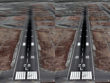
You can see that it certainly helps make things look better, but it also costs a bit of performance. Turning it off can help speed things up.
Antialiasing
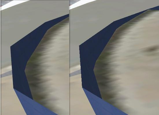
Anti-aliasing is a technique used to smooth the edges of features in an image. In Google Earth, this is particularly noticeable on 3D models. For example, here is part of the Georgia Aquarium with Google Earth’s Antialiasing set to “medium” on the left and “off” on the right. You can clearly see how much it improves the appearance of the building, though turning it off will help things to run a bit more smoothly. You can turn it off in the main [Tools] –> [Options] menu.
Terrain Quality
The entire globe in Google Earth is covered with a 3D terrain mesh. But adjusting the quality of that mesh, you can improve performance. Simply go to [Tools] –> [Options] and move the Terrain Quality slider further to the left.
Atmosphere
When zoomed out, Google Earth has a cool blue/gray atmosphere surrounding the earth. You can disable it by clicking on [View] –> [Atmosphere].
Water Surface
When Google Earth 5 was released, one of the big new features was the 3D ocean. Part of that new feature includes a realistic looking surface on the ocean. To disable that surface, go to [View] –> [Water Surface].
Cache
Google Earth keeps imagery in two types of caches to help improve performance. The Memory Cache holds imagery in your RAM, and is cleared each time you boot up your computer. The Disk Cache holds imagery on your hard drive for easier access. Incresing those numbers can help your performance. However, if you have a low amount of RAM or are low on hard drive space, you may be better off to decrease them a bit to give your computer a little more to work with.
None of these tips will make a huge difference by themselves, aside from any massive “Place” that you may have enabled, but added up they can make quite a difference. Play with some of the settings and see what happens.