Bing Maps – CachEye

Bing Maps – CachEye


CACH’EYE is a free personalised geocaching map service based on a Bing Maps application. Each user can define the content of his personal cachemap. Cache data are imported from Pocket Queries, from GPX- / LOC-Files or are exported from Geocaching Swiss Army Knife (GSAK) and visualised in an easy-to-use interactive map.

CachEye BING Maps OSM Layer
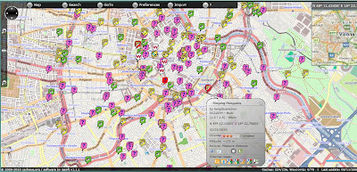
Clear, creative mapping for geocaches around the world.

Version 1.1 has many new features

  • Caches and additional waypoints now can be imported into the map directly from your Pocket Queries using the PQ-ZIP-File or still by using a GSAK-macro (as in V1.0), Up to 3000 caches plus waypoints may be displayed.
  • A single cache may be imported and visualized on the map via a GPX- or LOC-File.
  • Caches and additional waypoints now are associated to each other. With Focus/cache the map highlights and zooms to all waypoints of a specific cache.
  • ToDo-Lists assist you in quick and easy route planning. Todo-lists are named and you can maintain several lists.
  • Now you may move solved “Mysteries”, “Multicaches” and “Other Caches” to corrected coordinates on the map in case you did not import this cache from GSAK.
  • Openstreetmap also can be used as the basemap.
  • Measure distance tool
  • Altitude display (approx.) in Cache/Waypoint/Marker Popup
  • Metrics (km/miles) may be changed in account settings / information.
  • Displays waymarks on the map for GSAK-based datasets
  • Invoke the “Log Your Visit” page directly from within the map
  • Better appearance on 800×600 screen resolution

Map Demo:
http://demo.cacheye.org/

More information on CachEye

Paris Open Data Released

Paris Open Data Released

Paris OpenData in many different data types.

The data held by the City of Paris are fully exploited by the municipal services as part of their missions, but are also an intangible heritage that can be developed for the whole community:

  • researchers can find material to feed their work and experiences,
  • developers can create innovative services using these data,
  • citizens and journalists to find raw information,
  • companies can provide added value to these data, and thus create jobs and wealth for the community.

The movement “Open Data” (open data) is to get any type of structure, including local authorities around the world, the provision of all, free and free of electronic data. More Data to come in the weeks.


Now map it.
Paris Open Data Released in Open Street Map
Already in OpenStreetMap – http://demo.3liz.fr/opendataparis