The "GE Flight Simulator" gets update


Late last year we showed you Xavier Tassin’s Google Earth Flight Simulator, which is a very well-built flight simulator that is powered by the Google Earth Plug-in.


1.jpg 

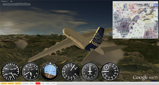
The site has seen solid growth over the past year, and now over 70,000 users visit each month, with 40 to 50 users connected at most times.

The latest version (.07) includes some nice upgrades:

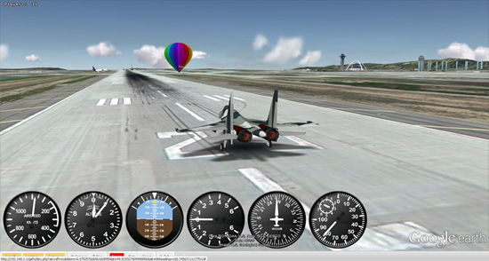
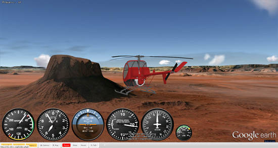
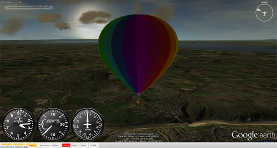
• 10 aircraft: from the Piper Cub to the A380, through Douglas DC3 and Sukhoi Su-35, helicopters and hot air balloon.

• A map rendering over 30,000 runways to take off from and DAFIF airspace charts (using Google Fusion Table and Google Maps)

• Real time, local weather conditions (Cloud coverage, wind speed), wind lift on relief.

• In-game chat

• Time slider to select current time of the day.

• Improved physics, animations, flight models, instruments and multiplayer

• Improved user interface, fine control settings, saved preference

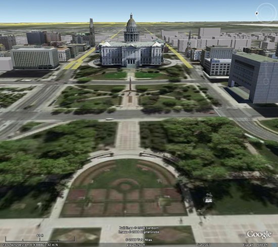
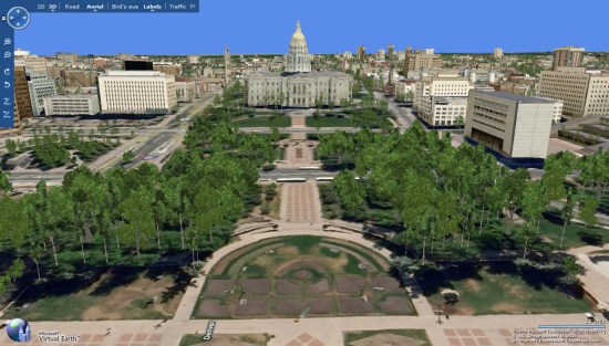
This is another great example of why it’s so great to build games using the Google Earth Plug-in — Xavier has certainly made some great enhancements, but there has also been thousands of new 3D buildings (and 3D trees) added to Google Earth in the past year, making it even better!

You can try it for yourself at ge-flightsimulator.com or check out a few more beautiful screenshots below.


2.jpg 


3.jpg 


4.jpg

Decline in Searches at Google & Bing

Comscore has an interesting post detailing a decline in “vertical search” (travel, local, product, jobs) queries for the first time in several years. This decline in searches at vertical sites has been mirrored by an attendant increase of share of searches at the general search sites.

From the article:

This trend is illustrated by the tremendous growth of non-search engine search entities during that time. In August 2011, of the 27 billion searches conducted on desktops in the United States, more than one-third occurred on non-search engines. Search on sites like Amazon, eBay, and Facebook has been growing faster than (and therefore gaining market share from) the core search engines for several years. But in the past year, this vertical search market actually contracted by 6% after several years of strong growth.

Vertical Search Giving Way to Core Search

He went on to conclude that with recent acquistions (like ITA and Zagat) and improved local and travel search results this trend is likely to continue:

As these user improvements manifest themselves in the search results and searchers have increasingly begun to rely on them for their more vertically-oriented search needs, we are finally beginning to see a significant shift in the market. Growth in vertical searches is now actually conceding ground to the core search engines in a reversal of the past few years.

Now, don’t go taking this as the beginning of the end of non-search entities. Their business is still alive and well and will continue to serve a critical function for specialized searching behavior. But increasingly, search engines are improving the quality of their results in a way that is helping to fill the void once created by searches with vertical intent.

Google Earth: 3D trees added to Boulder, Denver and Los Angeles

The addition of trees to Google Earth 6 was an awesome enhancement that made some big cities in Google Earth look remarkably more realistic. While they’re rolling out at a fairly slow pace, it’s nice to see Google continue to push it out to a few more cities.

The newest cities to get the trees are Boulder and Denver, Colorado and Los Angeles, California.

The new trees in Denver are of particular interest to me. I wrote a post on Digital Earth Blog more than three years ago comparing Denver in Google Earth and Microsoft’s (then-titled) Virtual Earth. At the time, Virtual Earth looked far better than Google Earth thanks to the trees. However, Google Earth has blown way past the look of Virtual Earth thanks to the improvements in satellite imagery and 3D buildings in the past few years.

First, here’s a look at the Colorado State Captiol building in Google Earth circa 2007. There are a few modeled buildings, a handful of gray buildings, and certainly no 3D trees:

ge-denver-2007.jpg

Next, here’s a shot from Virtual Earth, also in 2007. There are quite a few more 3D rendered buildings, but the textures on them aren’t very sharp. The trees are a nice touch, though:

ve-denver-2007.jpg

Finally, here’s a look at the same view in Google Earth, as seen today. The buildings are amazingly sharp, and the trees look far more realistic than what we saw in Virtual Earth in the past:

ge-denver-2011.jpg

This comparison helps to show why Google is taking so long between cities with the addition of 3D trees — they’re doing it right. Rather than clumps of virtually identical trees like you saw in Virtual Earth, they’re taking the time to get the right species and height of each tree. The results speak for themselves.

To see these new trees, simply search for Boulder, Denver or Los Angeles in your Google Earth search window and make sure you have [Trees] enabled in the [3D Buildings] layer.

Google Lat Long Blog

Geo Data Quality & Time to Fix

The Baltimore Sun reported on Saturday that Google Maps is erroneously showing the complete Intercounty Connector between I-95 and Gaithershburg Md as being open. Apparently Gogle driving directions are directing drivers along a 12 mile stretch between I-95 and Georgia Ave that still “is largely a muddy track where bulldozers are still doing what bulldozers do”.

This particular case is interesting to me for several reasons.

It is a high profile error in a very densely populated area of the US that has lots of road traffic. The Maps error has been picked up by the Washington Post and the regional NBC affiliate as well as the Baltimore Sun. Coverage of the issue has been persistent with the Baltimore Sun following up on their original reporting on 3/27 noting that 48 hours after reporting the problem to Google the problem is still in Maps.

Clearly, the reporter, Michael Dress of the Sun, thinks that Google should be able to fix the problem in a 2 day timeframe and is dismayed that it remains unrepaired. It is a reasonable expectation to think that a critical mapping error be fixed in 2 day timeframe. Whether Google can or will is another question. Typically they take 30-60 days to act on these corrections.  One of the realities of privatization of essential public services like this is that without strong and enforced regulations, the decisions like these are dictated by profit and not the needs of people. Should a private company that is providing a product for free be held to a higher standard when their product affects public safety in the public realm?

Secondly this story has already achieved a fairly high level of visibility by virtue of being covered in media sources that are very high profile and effectively national in scope. Google, in the past, has held that these types of public exposure have little impact on their willingness and speed to affect changes. Most in the SEO industry have seen obvious examples of “hand jobs” that seems to bely that. This will be an interesting case to test whether Google actually does intervene in these types of cases.

Thirdly and a bigger question is whether the overall quality of the underlying Maps data has improved over the past 12 months. Google stopped using TeleAtlas and started using their own geo data in October of 2009. They implemented a system of end user geo error reporting at the same. In May of last year, Google hired 300 temp workers in the Maps arena to improve the quality. As recently as last September, this reporting system was behind Google’s stated commitment of fixing geo errors in 30 days and there still was some reporting of whole towns going missing.

However since that time, complaints seemed to have dropped. While there have been some problematic and visible examples of large scale geographic map errors, for the most part the quality of the underlying map data seems to have generally improved. This seems to be true in both urban areas and rural areas as well.

Certainly the number of high level complaints on my radar has decreased. It was a common issue that affected visibility of business listings but reports in the Places forum of the problem have declined. Not a perfect proxy of reality but one that should reflect the general direction of the quality of the underlying data as businesses have a very high vested interest in being found and are thus motivated to report the problem. In my anectdotal test of Google’s mapping errors in my home town, most have been fixed.

It has been reported that Google receives over 10,000 corrections an hour to their maps. That’s a million corrections received every 4 days and over 87 million some odd changes every year. Do you think that they actually improved the underlying quality to a level appropriate for business listing accuracy?

Would love to hear your opinions on whether you think that Google has improved the quality of the underlying geo-data over the past year.

Tornadoes in Google Earth

With storms again ripping through the country, many of us are on the lookout for tornadoes. While it can’t help you prepare for one, Tornado Paths, created by Perry Samson at the University of Michigan, is a great way to view the locations and paths of past storms.

By default it shows all of the tornadoes that have hit the United States in the past 48 hours, but it has a few other nifty features.

• View “Today in History“, which shows all of the tornadoes that have struck on today’s date in the past 61 years.

• Use the search box to let you see all of the tornadoes that have struck a particular zip code since 1950. Very interesting stuff! For example, I now know that a 1986 tornado came within a few hundred meters of our current house.

tornadoes.jpg

Of course, it makes excellent use of Google Earth too. By clicking the “View in Google Earth link from the home page, you can view the most recent tornadoes in Google Earth.

tornadoes.jpg

As you can see, the tornadoes have a nice 3D semi-transparent affect, and some cows flying around nearby in an apparent homage to the classic movie “Twister”.