Google Earth: Remember 9/11

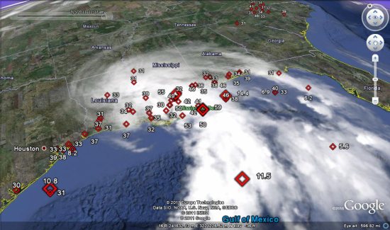
With the 10 year anniversary of the World Trade Center attacks coming up in a few days, we thought we’d look at some ways to use Google Earth to remember those lost in the attacks along with ways to look toward the future.

While Google Earth wasn’t released until nearly four years after the towers fell, a handful of models were built to show the towers as they stood prior to 9/11/01. By loading this KML file , you can see all of the towers that made up the original set of buildings, including the famous WTC 1 and WTC 2 buildings.

wtc.jpg

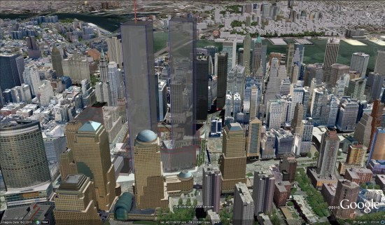
You’ll notice that some of the new WTC buildings, still under construction, are already visible in Google Earth. For the purposes of showing the area in a pre-9/11 state, you can right-click those buildings and Hide them. They’ll automatically re-appear next time you start Google Earth.

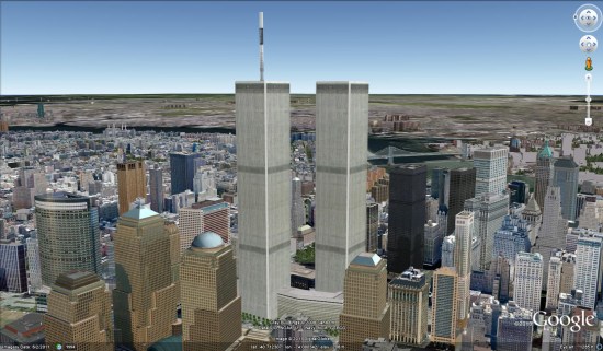
A more realistic-looking model was created by Patrick Griffin and can be found in the Google 3D Warehouse. His model, seen below, can be viewed by downloading this KML file.

wtc2.jpg

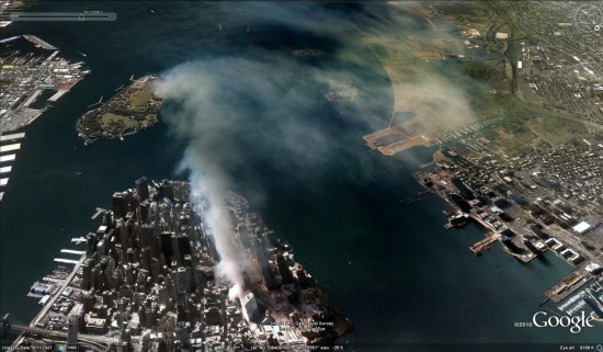
You can also use Google Earth’s Historical Imagery to view images of the twin towers by going back to 1997. The imagery isn’t in color and isn’t very sharp, but clearly shows the towers. You can also view imagery from 9/11/01, and see the smoke and dust as it floats out across the water.

smoke.jpg

There are also a variety of models that somewhat show how the attack unfolded, but none were particularly compelling. If you search the 3D Warehouse for something like “world trade center attack” you can find a few.

Google Earth: Tracking hurricane speeds

In 2006,  a tool from Jeremy Cothran at the University of South Carolina that provided a ton of near real-time weather data from various sensors around the southeastern United States.

Jeremy has now taken that vast amount of data, and simplified it to highlight significant events among those sensors. In particular, it highlights wind gusts over 30 mph or wave heights over five feet. The result, when combined with other tools such as Google’s built-in satellite overlay, can be quite useful.

wind-speeds.jpg

The more significant events are shown using larger icons, making it easier to see where the heart of the action is. You can also view the data using Google Maps, but it loses the label styling and time slider functionality.

Panoramio- Join a photo community to match your interests

When I get home, I upload my photos to Panoramio and position them on the map. Pictures uploaded to Panoramio can be featured in the “Photos” layer of Google Earth and Google Maps, which means that I can share my travel experiences with others and, in return, explore places around the world through the eyes of other photographers.

Starting today, you can share your passions through photographs more collaboratively with Panoramio Groups. This new feature lets you create a sub-community within Panoramio around a topic you’re passionate about, so you can easily engage with like-minded photographers and hobbyists.


Panoramio is an online community of people that share and explore photos of the world.

For example, in my trips around the world, I always take the time to enjoy the local cuisine, like Costa Brava’s arròs negre. So I created a group called “Food,” to give others a “taste” of that region and get a glimpse of what fellow foodies are feasting on. My fellow group members—and by all means I hope you’ll become one of them!—can add their own photos, browse others’ and get culinary and travel inspiration.

Panoramio Groups allow members to share photos and start discussions on a given topic.

To share your own interests and passions through photos, hop over to Panoramio and create your own group or join an existing one from the Groups Directory. You can show off your photos of your favorite restaurant, the most beautiful sunset you’ve seen, the latest lighthouse you’ve visited, or the cutest dog from each continent. Whatever it is, try starting a discussion about your favorite topics and share what matters to you with others.