Bing Maps REST Services now supports transit routes!

The Bing Maps REST Services has added a transit travel mode so you can get transit routes and even display a transit route on a static map in your application.  All you need to know is  where you want to go and what time of day and then the REST Services will return a transit route based on your request.  To get a transit route, use the existing URL for getting a route and specify the travel mode as Transit. Then set the new dateTime parameter to a time value and set the timeType parameter to  departure, arrival or lastAvailable and let the Bing Maps REST Services do the work. Transit route steps can include walking instructions as well as transit information.

To see how this works, check out these examples:

(Note: To use each of these URLs,  you must set the key parameter to a valid Bing Maps Key. For information about getting a Bing Maps Key, see Getting a Bing Maps Key.)

Example #1: Get transit route information

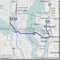
What if you’d like to take transit from the Space Needle in Seattle to the Bellevue Square Mall in Bellevue at 3 PM in the afternoon today. Here’s the URL that will tell you how.

http://dev.virtualearth.net/REST/V1/Routes/Transit?wp.0=Space%20Needle&wp.1=Bellevue Square Mall&timeType=Departure&dateTime=3:00:00 PM&output=xml&key=YourBingMapsKey

Example #2: See a transit route on a static map

You can also view the route on a static map and zoom in to see details at the start and end of the route.

http://dev.virtualearth.net/REST/v1/Imagery/Map/Road/Routes/Transit?timeType=Departure&dateTime=3:00:00 PM &wp.0=Space Needle&wp.1=Bellevue  Square Mall&mapVersion=v1&key=YourBingMapsKey

Example #3: Walking to the bus stop from Seattle Center

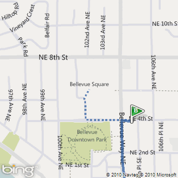
Note that a walking segment is displayed as a dotted line.

http://dev.virtualearth.net/REST/v1/Imagery/Map/Road/47.620495,-122.34931/15/Routes/Transit?timeType=Departure&dateTime=3:00:00 PM &wp.0=Space Needle&wp.1=Bellevue  Square Mall&mapVersion=v1&key=YourBingMapsKey

Example #4: Walking to Bellevue Square Mall from the bus stop

http://dev.virtualearth.net/REST/v1/Imagery/Map/Road/47.615635,-122.20435/15/Routes/Transit?timeType=Departure&dateTime=3:00:00 PM &wp.0=Space Needle&wp.1=Bellevue Square Mall&mapVersion=v1&key=YourBingMapsKey

Details on MSDN

This new feature is part of the Bing Maps REST Services. For details about how to get transit route information and how to display a route on a static map see the Calculate a Route and Get a Static Map topics on MSDN.
New BBC Travel Maps (Beta)

New BBC Travel Maps (Beta)

New BBC Travel Maps (Beta)
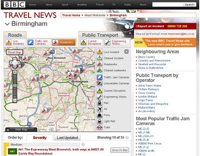
Improved Navigation and live feeds (jamcams included), much better Travel News from the BBC.

http://www.bbc.co.uk/travelbeta/birmingham/

What’s new:

  • Updated design, with wider pages and larger text.
  • Improved navigation, allowing movement between adjacent geographic areas
  • Interactive mapping, which can be minimised if you prefer the text incident list
  • Clearer timestamping of incidents.
  • Traffic jam cams showing frequently updated still images of traffic conditions on motorways and trunk roads

Addional Improvements

  • The text incident list has been updated to improve readability, and is synchronised with the map.
  • Local weather forecast from the BBC Weather Centre for the next 6 hours from now
  • Backend improvements to our data-handling system to categorise data, and speed up the reception and delivery of data to the site.


What’s not changed:

  • BBC’s comprehensive traffic and travel information remains at the core of the service, updated around the clock
  • The text list remains, and you can hide/minimise the map, to put the functionality of the site back to the way it used to be.
  • BBC have made the redesign as subtle as possible, in order to retain the things you’ve told us you like about the existing site.
  • In the final version of the site, you’ll be able to click to see a country-wide motorways or major roads overview from every page.
  • BBC’s door-to-door journey planner, powered by Transport Direct, remains but has been made more prominent.


Why a new version of BBC Travel News:

“Firstly, to update the design to take advantage of the BBC’s wider page layout, introduce maps across the site for the first time, and make some basic improvements to the presentation of our information
Secondly, to improve the data-handling processes behind the scenes, to allow us to separate the data into more useful groups, and reduce the time it takes for the data to reach you
Thirdly, to integrate traffic jam cameras (where available) into the main BBC Travel News website alongside our incident data”

Current BBC Travel Maps (Beta) Areas:

Birmingham beta
Black Country beta
Coventry beta
Herefordshire beta
Shropshire beta
Staffordshire beta
Warwickshire beta
West Midlands beta
Worcestershire beta
Wolverhampton beta

Mapperz Mapping News Blog