2012 Google Model Your Town Competition

[Cross-posted from the SketchUp blog]

Following the success of last year’s Google Model Your Town competition, today we’re launching the second Google Model Your Town Competition. Model Your Town is about geo-modeling – making photo-textured models of real-life buildings that appear in Google Earth. The Model Your Town Competition is also a chance to celebrate your town by adding it to the 3D map. Of course, the USD$25,000 for a local school/district is a nice incentive too.

Barranco, Lima, Peru


The Model Your Town Competition is open to just about everyone, just about everywhere in the world. Form a team, model buildings (using SketchUp or Building Maker) and upload them by the end of February 2012.

You can model as many structures as you like – which types of buildings you choose to include is entirely up to you. The important thing is that your choices say something about the character and history of your town.

If your town wins, a bunch of us from the SketchUp team will visit, throw you a dinner party and do our best to make you feel like the local hero that you truly are. Check out the competition website for details, and start rounding up teammates!

Learn more at Your World in 3D, then get started modeling your town!

Google Earth: Canada’s largest intact forest

In just three minutes, you can take a non-stop, coast-to-coast Google Earth narrated tour of Earth’s “green halo:” the boreal forest. The Pew Environment Group takes you over the vast northern forests and waterways and unveils an ecosystem that stores twice as much carbon per acre as tropical rainforests, holds more freshwater than any other continental-scale ecosystem and teems with wildlife. Watch the tour below or download the KML file to view in Google Earth.

The Pew Environment Group is the conservation arm of The Pew Charitable Trusts, a nongovernmental organization that works globally to protect our oceans, preserve wild lands and promote clean energy. Pew and its sister organization, the Canadian Boreal Initiative, developed this tour to illustrate the nature of the blue forest and its ability to store massive amounts of carbon, primarily in its soil and wetlands. The tour is featured at the launch of Google Earth Outreach in Canada, happening this week.

Viewers will see bears, wolves, and caribou that still roam this vast landscape, learn about aboriginal communities that depend on the boreal, view the Peace-Athabasca Delta, one of the most important wetlands in the world, and the last refuges for North American Atlantic salmon.

The Peace-Athabasca Delta viewed in the Pew Environmental Group’s new Google Earth tour.

Unfortunately, Canada’s boreal forest is increasingly affected by large-scale industrial activities. A rapidly expanding footprint of development already includes 180 million acres (728,000 km²) affected by forestry, road building, mining, oil and gas extraction, and hydropower.

Pew and CBI have worked with aboriginal communities, conservation groups, federal, provincial and territorial governments to protect the boreal, resulting in 185 million acres set aside from development to date, including key wetland and river areas. That total represents more than 12% of Canada’s 1.2 billion-acre (nearly 4.9 million km²) boreal forest.

Visit us online to learn more about the steps we can take together to protect this global treasure.

Bringing the Dead Sea Scrolls

It’s taken 24 centuries, the work of archaeologists, scholars and historians, and the advent of the Internet to make the Dead Sea Scrolls accessible to anyone in the world. Today, as the new year approaches on the Hebrew calendar, we’re celebrating the launch of the Dead Sea Scrolls online; a project of The Israel Museum, Jerusalem powered by Google technology.

Written between the third and first centuries BCE, the Dead Sea Scrolls include the oldest known biblical manuscripts in existence. In 68 BCE, they were hidden in 11 caves in the Judean desert on the shores of the Dead Sea to protect them from the approaching Roman armies. They weren’t discovered again until 1947, when a Bedouin shepherd threw a rock in a cave and realized something was inside. Since 1965, the scrolls have been on exhibit at the Shrine of the Book at The Israel Museum, Jerusalem. Among other topics, the scrolls offer critical insights into life and religion in ancient Jerusalem, including the birth of Christianity.

Now, anyone around the world can view, read and interact with five digitized Dead Sea Scrolls. The high resolution photographs, taken by Ardon Bar-Hama, are up to 1,200 megapixels, almost 200 times more than the average consumer camera, so viewers can see even the most minute details in the parchment. For example, zoom in on the Temple Scroll to get a feel for the animal skin it’s written on—only one-tenth of a millimeter thick.
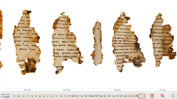
You can browse the Great Isaiah Scroll, the most well known scroll and the one that can be found in most home bibles, by chapter and verse. You can also click directly on the Hebrew text and get an English translation. While you’re there, leave a comment for others to see.
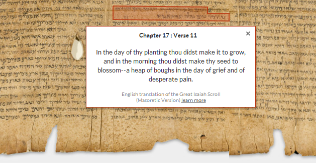
The scroll text is also discoverable via web search. If you search for phrases from the scrolls, a link to that text within the scroll viewers on the Dead Sea Scrolls collections site may surface in your search results. For example, search for [Dead Sea Scrolls “In the day of thy planting thou didst make it to grow”], and you may see a link to Chapter 17:Verse 11 within the Great Isaiah Scroll.

This partnership with The Israel Museum, Jerusalem is part of our larger effort to bring important cultural and historical collections online. We are thrilled to have been able to help this project through hosting on Google Storage and App Engine, helping design the web experience and making it searchable and accessible to the world. We’ve been involved in similar projects in the past, including the Google Art Project, Yad Vashem Holocaust photo collection