The pyKML – a Python library for manipulating KML

pyKML is an open source Python library for generating, parsing, and modifying KML, the geo-spatial data language used by Google Earth, Google Maps and a number of other GIS platforms.

I was motivated to create pyKML because I frequently need to visualize large, and often complex, environmental datasets. While the KML language has a wide range of options for styling, annotating and interacting with geo-spatial and temporal data, most programs that generate KML don’t take full advantage of these rich features. I created the pyKML library to address this problem by providing easy, programmatic access to all KML elements.

pyKML facilitates working with large and complex KML documents by leveraging the use of basic programming constructs (looping, branching, etc.). In this regard pyKML is similar to libkml, Google’s open source C++ library, but takes advantage of the highly readable syntax of the Python programming language and the processing capabilities of the popular lxml Python library.

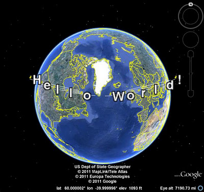
As a simple example, check out this Python script that loops through a text string (“Hello World!”) and uses pyKML to create a series of KML Placemarks. You can download the resulting KML document, and below is a screenshot of how it looks in Google Earth.

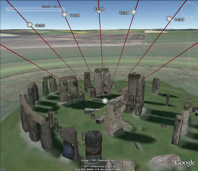
This is just a teaser of what pyKML can do. For more complex examples, check out the pyKML documentation and the project’s Google Code site that includes sample code for: generating KML from CSV data, creating KML Tours, and visualizing ephermeris data for Stonehenge (e.g., orientation of the sun on different dates). pyKML can even be used to create “slides” for presentations!

To get started, browse the project’s documentation, install the library, try it out, and let us know what you think!

via:  Tyler Erickson, Senior Research Scientist / Engineer, MTRI
French Court Fines Google For Offering Its Maps For Free

[googleMap]600|400|5|0|0|France|French Court Fines Google For Offering Its Maps For Free[/googleMap]

A French court has ruled that Google is guilty of abusing the dominance of Google Maps, and so has ordered it to pay a fine and damages to a French mapping company.

Apparently Bottin Cartographes argued that Google was planning to offer Maps for free only until all the competitors had been driven out of business — then, it argued, Google would start charging, reports AFP. The result? The court ordered Google to pay $660,000 in damages.

Understandably, Google is looking to appeal. Surely that stands a good chance, seeing as the argument used by Bottin is nothing like Google’s usual policy of giving away services for free, in exchange for, well, all your personal information. [AFP]
Via: Gizmodo

The Garmin’s Course Creator

With today’s Garmin Connect update, navigation on bike lanes, running and hiking trails, and walking paths just got a whole lot easier. Gone are the days when you’d have to stop during your best trail run, epic hike or cycling adventure to take out your paper trail map and double check that you are headed down the right path. Now you
can use our Course


Creator – and with a few simple mouse clicks you can draw your route using Google maps, save it and send it directly to your compatible

Garmin device. With Google maps, you can even show your local bike lanes in Kona, HI, jogging paths through Central Park, and even hiking trails in Whistler, BC to name a few great destinations!

Once your course is saved, you can allow it to be stored publicly for users around theworld to view and they can send to their devices so they can experience your favorite route as well. This feature, we call Explore, is great when travelling to a new city, away on business or for those who want to break their same old routine and try a new route.


You’ll also notice an improved ability to zoom on our number of detailed graphs when analyzing your most recent adventure.