Google Maps Masups 14

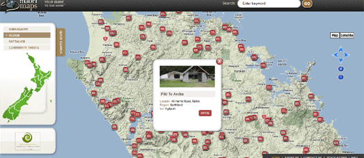
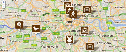
Loughborough University Campus Map


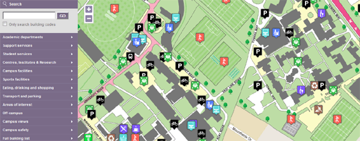
Loughborough University’s campus map is a great example of how to use the Google Maps API to help students and visitors find their way around a large campus.

The map uses the custom overlays function to overlay a custom map of the university on top of the Google Map. The custom map overlay includes features and locations that are not on Google Map’s own map tiles, such as trees, tennis courts, football pitches etc.

The map also makes good use of polygons to make buildings on the map interactive. If you click on any of the buildings you can view the building’s name, a photo of the building and links to its page on the university’s website.

Finally, the map includes a very nice search facility that allows you to search for a building or feature by name or by category.

Greenpeace – Moscow Recycling Map


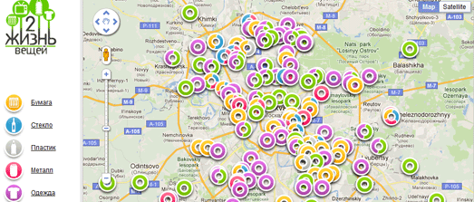
Greenpeace has released a Google Map of recycling stations in Moscow.

The map shows the locations of recycling stations for paper, glass, plastic bottles, old electronics and clothing in the Russian capital. The map includes custom made markers that are colour coordinated to indicate the type of recycling possible at each station.

It is also possible for users to add the location of missing recycling locations to the map.

Google Hotel Finder


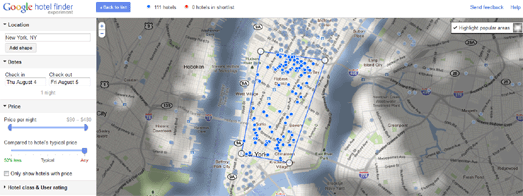
Google has today launched Hotel Finder, a new search tool to help you find a hotel.

The tool includes an interesting Google Maps interface that allows you to search for hotels by location. When you enter a location into the Hotel Finder the map shows an initial shape based on the most popular area for visitors to stay. Users can drag the shape to define more closely this area, e.g. close to the ocean or along Sunset Boulevard.

Hotel Finder also shines a “tourist spotlight” on the most visited areas in the selected city. Tools in the sidebar allow you to adjust the price of hotels you wish to view on the map and to compare the current price to the hotel’s typical price.

Livebookings Live Map


Online clothes retailer Zappos started a trend when they created their live Zappos Map. This real-time map was created to show the latest orders placed on Zappos live on a Google Map.

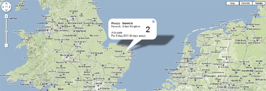
The Zappos Map was quickly followed by Net-a-Porter Live, ThisNext and The Book Depository Live. Now Livebookings, Europe’s largest online booking service for restaurants, has released a live map of restaurant tables booked by its customers.

Livebookings Live takes the reservations coming in, removes the customers’ names, and plots them on a map showing where, for how many, and with what frequency the Livebookings system is used.

Geohashing Wiki


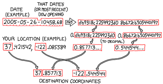
The xkcd Geohashing Wiki is inviting you to participate in the wonderful world of random location meet-ups.

Geohashing is a method for finding a random location near your current location and then visiting it. Every day the geohashing algorithm generates a new set of coordinates for your location. Everyone in a given region gets the same set of coordinates.

After you have visited the random location you can document your expedition on the Geohashing Wiki, including details of who was involved in your expedition and pictures of your adventure.

To get your daily randomised coordinates visit the Geohashing Google Map. Click on the map to show your location and, using the geohashing algorithm, your random location will be generated by the map.

Zoopla: UK Property Heat Map


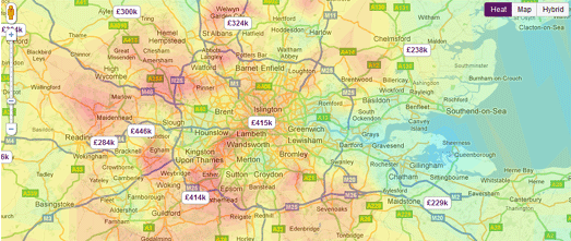
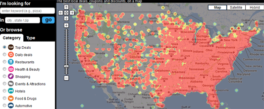
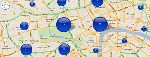
Real-estate website Zoopla has created a heat-map of UK property prices.

The Google Map provides a quick overview of where properties are affordable and where houses are more expensive. For example if you zoom in on London, you can see a distinct pattern of expensive property in the commuter belt around the capital.

World Tour Schedules on Google Maps


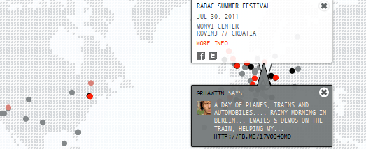
Artist / DJ Richie Hawtin has created a gorgeous looking Google Map for his current world tour. Custom map tiles have been used to give the map a distinct design. The dot-matix look of the design is continued in the custom made map markers and information windows.

Dates on the tour are displayed on the map and a slide-out sidebar shows the dates in list form.

The ‘One City’ world tour continues until December.

Google Maps Mashups 9

Google Maps meet Maori Maps


This Google Map displays the locations of the tribal marae of Aotearoa New Zealand. A marae is a communal or sacred place, the centre of Maori identity and activity.

Maori Maps is a nationwide map of Aotearoa marae, with photos of each marae, contact and background information, and photographs. Currently the map displays marae in the Tai Tokerau (Northland) and Tamaki (Auckland) regions. Eventually the map will show all of Aotearoa’s more than 800 ancestral marae.

Maori Maps

Google Aquires Dealmap


Dealmap’s biggest deal of today was selling itself to Google.

Websites offering daily deals and coupons have been one of the biggest trends in the location sector for a couple of years now. Google has been pretty keen to get into this market, which has so far been dominated by Groupon.

However Google has, until now, been painfully slow in rolling out its own Google Offers site. Google Offers launched in April promising daily offers – but the deals were initially only available in Portland, Oregon. Since then Google have rolled out the service to other areas but it is still limited to New York, San Francisco, Oakland and Portland.

By acquiring Deal Map Google can now access Dealmap’s deal exchange distribution network and presumably hopes to tap into Dealmap’s over 2 million users.

Google is not the only big player to have had an eye on Dealmap. Back in March Dealmap signed a deal with Bing to display deals on the homepage of m.bing.com.

For now Dealmap says it will continue as a distinct service. However my guess is that at some point in the future Dealmap and Google Offers will morph into one product (probably called Google Offers).

Google Maps at the Fringe


The world’s largest art festival the Edinburgh Fringe is due to start on Friday.

With over 2,000 different comedy, musical and theatrical shows taking place in over 250 different events what is needed is a Google Maps guide to the Fringe.

Enter stage right – Gigglemaps.

Using Gigglemaps you can click on any Edinburgh Fringe Festival venue and view the next five performances. The map includes a menu that allows you to filter the venues by category, such as comedy, cabaret etc.

Gigglemaps

The Google Maps Guide to Hiking in Norway


UT.no is a complete guide to hiking in Norway. The site features hiking routes, cabins, a calendar of events and a hiking map built with the Google Maps API.

As well as the usual Google Map views the map features detailed topographical map tiles. Using the menu in the map sidebar you can select to view cabins, summer trails, winter trails, videos, articles and even current skiing conditions.

Kart – UT.no

Boston’s Buses Live on Google Maps


With TransitSpy you can follow Boston’s MBTA buses live on Google Maps.

Using the sidebar you can select any combination of MBTA bus routes and view in real-time the position of the buses on those routes. As well as the live buses all the stops on a route are displayed on the map. If you click on a bus-stop’s map marker you can see how long you will have to wait until the next bus arrives.

TransitSpy MBTA

Loads More Birds Eye View


Mezquita-Catedral

Google Maps today has a lot more aerial view imagery. The update includes new 45° imagery in the U.S., Canada, Germany, Argentina and Spain.


Parliament, Ottawa

Here’s a list of the updated cities:

Augsburg, Germany. Barstow, CA. Bartlett, TX. Big Bear, CA. Blackstone, VA. Catalina Foothills, AZ. Córdoba, Spain. Delano, CA. Desert Hot Springs, CA. Richmond, VA. Elgin, TX. Healdsburg, CA. Helendale, CA. Hemet, CA. Houston, TX. Mendoza, Argentina. Midlothian, VA. Napa Valley, CA. New Braunfels, TX. Ojai, CA. Ottawa, Canada. Pensacola, FL. Porterville, CA. Plant City, FL. Rancho Del Lago, AZ. Rosario, Argentina. Santa Clarita, CA. Sarasota, FL. Taylor, TX. Temecula, CA. Treasure Island, CA. Troy, IL. Twentynine Palms, CA. Wakefield, VA. Yucca Valley, CA.


Rathaus, Augsburg

googlemapsmania

Google Maps Maships 8

Google Map for the 2011 Hurricane Season

Google Crisis Response has put together a Google Map for the 2011 Hurricane Season. The map currently shows the projected route of Hurricane Irene with the option of viewing a number of other layers on the map.

As well as viewing the forecast track of Hurricane Irene the map includes:

  • a cloud imagery layer from the Navy Research Lab
  • a layer showing coastal areas placed under tropical cyclone watches or warnings
  • evacuation routes from FEMA
  • a surge storm probability layer
  • real-time Stream Gage Data from USGS

Culture on the Map

In the UK tourist signs have a brown background and are often referred to as ‘brown signs’. Their purpose is to direct people to tourist attractions, such as castles, museums or historical buildings.

Brown signs are the responsibility of local authorities and therefore there is no central record of all the country’s brown signs. Follow the Brown Signs is a website dedicated to tracking down (and mapping) all the humble brown signs in the UK.

It is possible to search for brown signs by address or postcode and view a Google Map of all the signs around that location. There are 93 different types of brown signs, signifying such diverse categories as good brass rubbing locations and ‘heavy horse’ centres.

Follow the Brown Signs lets you search for brown sign locations by category. As well as providing a little history about each category you can also view each of the 93 different types of brown sign on its own individual map.

The UK’s Blue Plaque scheme is a way of commemorating the lives of famous residents of the country. Blue circular signs are erected on houses to indicate that someone of note was born or once lived there.

The PlaqueGuide is a Google Map of the UK’s blue plaque houses. The map uses blue circular map markers to show the location of houses with plaques. You can find out who the plaque is for by just mousing over a marker. If you click on a marker you can view a Street View of the plaque and read a Wikipedia article about the individual commemorated by the plaque.

The PlaqueGuide is crowdsourced, so anyone can add information about the location of a blue plaque.

History on Google Street View

I think there is something kind of magical about viewing old film clips on top of the modern Street View image of where the movies were shot. I’ve updated my There and Then historical videos application to try and improve the user interface.

I’ve also added a few more historical videos. Some highlights of the more recently added videos to the app include a 1960’s film of the Vatican and a 1950’s film of the Colosseum in Rome.

I’d love to hear what you think about the app, particularly whether you think the user interface is intuitive or a little difficult to understand. So feel free to tell me what you think in the comments.

The Old San Francisco

Old S.F. is a great Google Map of thousands of historical photographs of San Francisco. The map provides a great way to browse the San Francisco Public Library’s Historical Photograph Collection by location and by date.

The map includes a slider navigational aide that allows you to select a date range for the photographs you wish to view. For example, if you are interested in viewing photographs taken after the 1906 San Francisco earthquake you can set the slider to 1906 to view only the photos taken in that year.

Time Shutter is another great Google Maps based website that allows users to view historical photographs of San Francisco. Users can upload historical images to the site and browse through the images submitted by others.

The site includes many postcards of San Francisco from around 1900 and includes a historical map overlay featuring the Chevalier Commercial, Pictorial and Tourist Map of San Francisco from 1903.

Measuring Twitter

Last week’s Virginia earthquake may only have measured 5.8 on the Moment magnitude scale but it measured a whopping 10.6 on the Twitter scale.

This Twitter Quake Map shows the astonishing rate and spread of Twitter messages about the quake in the 8o seconds after it hit. As the map animates through the 80 seconds, the location and density of the Tweets radiate out from Virginia, almost exactly like the shock or P waves of the quake itself.

@andreitr

NOCA Interactive Map

This Google Map from the North California Chapter of the Documentation and Conservation of Buildings, Sites and Neighborhoods of the Modern Movement (DOCOMOMO/NOCA) shows the location of some of San Francisco’s most important Modern Movement buildings.

It is possible to browse the map by location, building or by architect. The map also includes four walking tours in different areas of the city that will take you past some of the most important buildings in each area.

The DOCOMOMO/NOCA website was built by creative company Ted Perez + Associates.

Trip Planning with Tripomatic

Tripomatic can help you create a personalised trip itinerary for a number of major destinations in Europe.

Creating an itinerary with Tripomatic is incredibly simple. Each destination includes a Google Map featuring the city’s attractions, places to eat and hotels. You can select to view a number of categories to view on the map.

Clicking on an attraction’s map marker will open an information window with details about the attraction. If you want to visit the attraction you simply add it to your personal trip itinerary. Once you think you have enough attractions for one day you can simply add another day to your itinerary.

After you have completed your itinerary Tripomatic will devise a Google Map for each day of your trip, that includes all of your selected destinations. Your personal itinerary guide includes your map and details about all of your selected attractions presented in an easily printable form.

All you need to do then is print out your personal guide and pack your bags.

MySociety’s FixMyStreet

MySociety’s FixMyStreet was a leading pioneer in what might be called report mapping.

FixMyStreet created a system that allows residents to view and report problems, such as graffiti, fly tipping, broken paving slabs, or street lighting to their local authorities. MySociety has now created a similar report mapping application to help people get common public transport problems resolved.

FixMyTransport is targeted specifically at problems such as broken ticket machines or buses that always leave early. The application uses Google Maps to allow users to find a specific station or bus-stop where they wish to report a problem.

It is also possible to view a Google Map showing all reported problems in a specific area. From the information users provide FixMyTransport can then report problems through to the correct department of the operator or local authority in charge.