“Find My Friends” – The New iPhone App for Location Sharing


One of announcements from today’s Apple event was an interesting new app called Find My Friends.

The app lets you track the location of other users, but unlike Google’s Latitude, which is meant to be used with a wide circle of people you know, Apple’s app seems designed for use with a close circle of friends and family.

Apple’s examples of how the app can be used includes checking out if your son made it to school today.

Of course, not everyone wants to be tracked all the time, so Apple has included some privacy options, such as temporary location sharing. (For example, you can set up the app to share your location up until 7 p.m. each day.)

We can imagine a lot of parents will like the app, but a great deal of kids will probably hate it, or think of ways to circumvent this type of surveillance.


The Earliest GPS Device

They are notorious for guiding exasperated motorists down footpaths, into ponds or to the wrong city entirely.

But the modern-day sat-nav is likely to pose far fewer problems for lost drivers than its 1927 forerunner.

The Plus Four Wristlet Route Indicator, which has gone on display at a National Trust house, is thought to be the first navigation device for motorists.
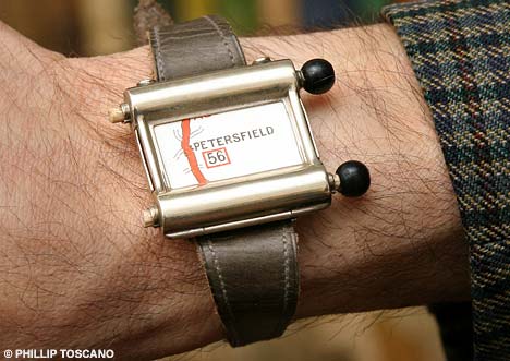
 

Eccentric invention: the Plus Four Wristlet Route Indicator’s tiny interchangable paper maps seem quaint compared with their modern counterparts

Worn like a wrist-watch, it is loaded with a tiny paper road map that is rolled across the face by adjusting two small black knobs.

It comes with set route maps, such as London to Bournemouth and London to Edinburgh, and the driver winds the knobs to move the map on as their car travels further.

When motorists wish to turn off the road, they have to pull over to replace the map with another map that corresponds to a number on the junction.

The ingenious but fiddly device was never mass produced and would have only been used by the tiny section of the population who could afford cars.

It also has a function to allow the wearer to keep golf scores, which indicates it would have been worn by a Bertie Wooster type of person from P.G. Wodehouse’s famous novels.

It is one of the key attractions at the Curious Contraptions exhibition of eccentric inventions from the Victorian and Edwardian eras, at Standen House in East Grinstead, East Sussex, on various dates until 1 June.

Owner of the collection Maurice Collins, 73, from Muswell Hill, London, said it was of his most unusual items.

“It’s an amazing invention and I have never seen another one like it,” he said.

“The idea is that if you want to go from London to Bournemouth you put that map into the watch and then as you drive along you wind the device to keep pace with where you are.

“It is very amateurish and very simplistic.

“Sadly I’ve never tried it myself and I’m not sure how successful it would be as a navigation device.

“It’s a bit of an eccentric invention.

“It’s the sort of thing you can imagine Bertie Wooster using and then his butler Jeeves having to dig him out of a hole.”

The wristlet would have cost around £5, which in today’s money is about £45 to £50, Mr Collins added.

It comes with around 20 maps but more could be ordered to cover the entirety of the country. Most of the set journeys start from London.

Christopher Hill, visitor services manager at Standen House, said it was an ingenious idea.

“It is a great idea but it would have been quite fiddly to keep winding the map on as you drove and when you wanted to change a map you would have to pull off the road,” he said.

“It would probably have been used by people who were taking day trips from London and would have been sold in car shops alongside driving gloves and maps.

“Modern sat-navs cause a lot of problems but I think they might be a bit more reliable than this gadget.”

Other gadgets on show at the nineteenth century exhibition include a hem measurer, a brothel clock, which helpfully projects the time onto the ceiling, and the portable desk for writing while on a train.

How to make the Google Earth Flight Simulator easier to use


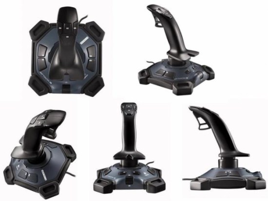
Alan Huestis writes the Google Earth Flight Sim blog, as he is a big fan of that feature in Google Earth. Like many of you, he purchased a joystick (the Logitech Attack 3) to help make the sim feel more realistic, but he wasn’t happy with the button mapping. To solve that, he re-wrote the joystick.ini file to make it easier to use.


logitech-attack-3.jpg 

Here are the changes he made:

  • I use the original code to handle joystick movement (back and forward, side to side) and to handle the throttle.
  • I have four keys on the top, and I use the side keys to move the rudder in 20% increments. The centre key returns the rudder to centre, and the top key just pauses the action so I can answer the phone. On the small plane I do not usually use the rudder but on the jet there is much more need of rudder as one can’t turn much by just banking.
  • I have two buttons on the left side of the base and I use them to increase the flaps by 20% and decrease the flaps by 20%.
  • There are two buttons at the rear of the base and I have mapped them to the left and right brakes. On the small plane one can steer on the ground with the brakes, and even turn around on a runway and take off again. The brakes do not seem to slow the jet much and I often overshoot a runway even though I am safely down.
  • There are two buttons on the right side of the base and I have used those to control attitude but I rarely use them in flight.
  • I have mapped the trigger key to change the view. In normal flight we look out over the nose and we see the instrument display. When I pull the trigger the instrument display disappears and the view angle changes to downwards and slightly forward. I usually fly the small plane, and with full flaps and half throttle, flying at about 500 feet, and with the trigger depressed it seems like I am an eagle soaring over familiar landscapes. The effect is just magical. At that airspeed I can still maneuver and climb slightly, but it is slow enough that the earth beneath me does not blur.

Here is the .ini file that Alan wrote to work with his joystick, named “Logitech_Attack3.ini”:

controllers_supported = [
Controller(‘*Logitech*Attack*3*’, 11, 11, 3, 3)
]

button_press = [
B0 set(VAngle, -0.35)
B1 set(DR, 0)
B1 set(dDR, 0)
B2 toggle(TotalFreeze)
B3 set(dDR, -0.8)
B4 set(dDR, +0.8)
B5 add(DF, -0.2, 0, 1)
B6 add(DF, 0.2, 0, 1)
B7 set(DB_0, 1)
B8 set(DB_1, 1)
]

button_release = [
B0 set(VAngle, 0)
B3 set(dDR, 0)
B4 set(dDR, 0)
B7 set(DB_0, 0)
B8 set(DB_1, 0)
]

axes = [
A0 set(DA, 1.0, 0.0)
A1 set(DE, 1.0, 0.0)
A2 set(DP_0, -0.5, 0.5)
]

povs = [
]

In his case, the file is located here:
C:Program FilesGoogleGoogle Earthclientresflightsimcontroller

Simply replace that file with the contents above (after you back it up, of course) to be able to use his settings.