Google Maps: Preview your route in 3D

Getting directions is one of the most popular features on Google Maps, whether it be for driving, walking, biking or transit. Today, we are launching a new feature that allows you to bring your upcoming trip to life, by allowing you to preview your route in 3D.

Let’s say you’re planning a road trip down the beautiful coast of California’s Highway 1 and want to be able to see what the route really looks like. California’s rugged coastline is not to be missed, but the top-down view really doesn’t give you a good sense of what this majestic terrain is like. Using the 3D preview; however, you can get aerial view of the route, as if you were in a helicopter flying above the road.

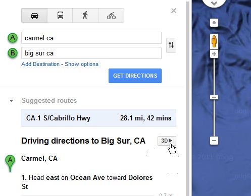
To preview your own route, it is as simple as clicking on a button. Start by entering your starting point, destination, and mode of transport like any directions; in this case, driving directions from ‘Carmel CA to Big Sur CA.’ Then, just click on the “3D” play button. The map will switch to Earth view and automatically start flying you along your recommended route.

You can pause the flight at any time by clicking anywhere in the 3D view or on the pause button in the lower left. While the flight is paused, you can explore the surrounding area in 3D by clicking and dragging the map. When you are ready to resume the flight, simply click on the play button in the lower left of the 3D view.

To help you keep track of which step you are on, the current leg of the trip is highlighted in the left panel. You can also jump to a different part of the trip by clicking on a different step.

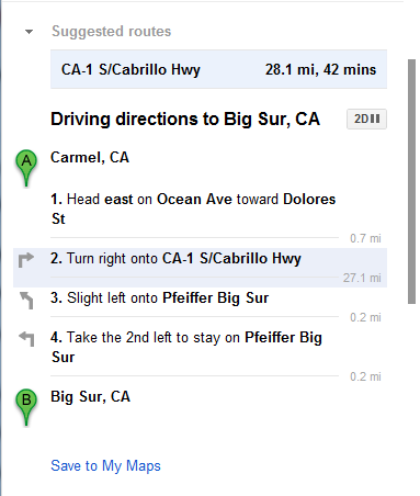
You can get back to 2D mode by clicking on the “2D” button in the left panel at any time.

Sightseeing The busiest airports of 2011


Over the years, the folks at Google Sightseeing have continually produced excellent content. They tend to use Google Maps for their views, so we always like to see how their locations look in Google Earth as well. In the past year or so, we’ve shown you some of their items such as the set of “Wipeout” and exploring the deserts.

Their latest feature covers the Top 5 Busiest Airports of 2011. Living in Atlanta, home of the world’s busiest airport, these kinds of stories always interest me. The numbers shown below are the total number of passengers from January-May, 2011. Let’s get to the list.

5. Los Angeleas International Airport (LAX) — 24,230,832

lax.jpg 

4. O’Hare International Airport (ORD) — 25,986,415

ohare.jpg 

3. London Heathrow Airport (LHR) — 26,733,585


lhr.jpg 

2. Beijing Capital International Airport (PEK) — 31,080,482

pek.jpg 

1. Hartsfield-Jackson Atlanta International Airport (ATL) — 36,548,629


atl.jpg 

Another neat image of the Atlanta Airport comes from the folks at Trendsmap. They captured all of the geo-located tweets in the Atlanta area over the course of a year, then plotted them against a dark background. The result is quite cool, as you can clearly see the various terminals of the airport, which are connected by underground tunnels. (details on Flickr)


atl-twitter.jpg 

For other interesting airports in Google Earth, check out the scariest airports in the Caribbean, or perhaps Peter Olsen’s amazing recreation of the 1977 Tenerife Airport disaster.


GoogleEarthBlog

Google Maps Design Evolution

The start of a comprehensive visual redesign for Google Maps founded on three key principles: focus, elasticity, and effortlessness. This week Google continuing to implement that philosophy by improving and evolving a few key features.

Perhaps the most notable change is an update to the styling and color of  iconic pins across all Google properties. This change reflects our interface’s recent design evolution, introducing a more harmonious visual relationship between the on-map markers and the map itself.


On-map controls are also now more visually aligned with the rest of our design system. Together these changes reflect our recent efforts to reduce unnecessary clutter and give greater priority to information on the map.


In the header we’re also introducing more prominent buttons for Directions and My places integrated into an elastic interface that expands and contracts to best fit your browser window size.

Putting all of these changes together you get:

We hope you find this a welcome update making Google Maps more functional, effortless, and enjoyable. This is just one part of the many design updates that will continue rolling out across Google Maps in the coming weeks and months, so keep an eye out for more!