John Harlin Live Google Map
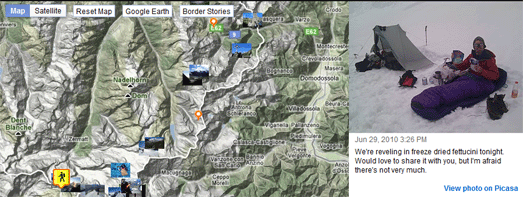
American author and adventurer John Harlin has set out on an epic journey to follow the entire Swiss border under his own power, a 2,000km odyssey with more than 170,000m of climbing. You can follow John’s journey on swissinfo.ch’s John Harlin Live Google Map.
The map shows John’s current position (at the time of writing he appears to be approaching the Matterhorn). The map also includes the amazing photographs that John has taken on his journey, links to John’s daily reports and some of the interesting features and points of interest that John is passing on his epic journey.
Browse the New York Times by Location
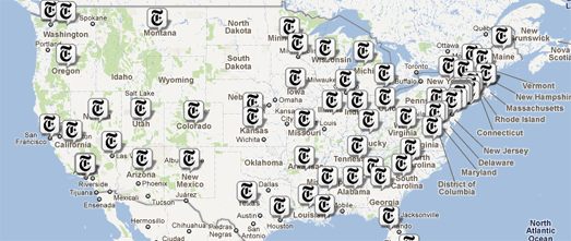
You can now browse the New York Times by location using the Longitude Google Map.
Geotagged news stories are displayed on the map with a Times ‘T’ logo. If you click on a map marker an information window opens with ten recent articles from the paper for that location.
Beneath the map you can view a list of locations from today’s edition of the paper. Clicking on these links will also open the relevant information window on the map.
Read Write Web
Vermont Flooding 2011 Google Map

Google Crisis Response has released a Vermont Flooding 2011 Google Map.
The map shows road and bridge closures in the state. It is also possible to overlay other layers on the map showing:
- cloud imagery
- USGS Real-time Streamflow
- significant river flood outlook
- Red Cross shelters
- Vermont county borders
Build a Google Map
Build-A-Map is a new Google Maps creation tool to help users build visually appealing, functionally rich, and interactive maps with minimal effort.
Using the simple point-and-click interface users can create custom maps, publish the map on Build-A-Map’s servers and then simply embed it in their own website or application. You can view examples of Google Maps created with Build-A-Map on the demo page.
Currently Build-A-Map is in beta testing. You can sign up now to be an early user.
The Circle Count Top 100 Google+ Users Map
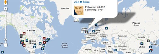
Everyone knows that the real purpose of social networks is to gauge how popular you are by the number of followers you can collect. Circle Count is a new website that is tracking the most followed people on Google+.
Circle Count lets you enter your own Google+ profile and find your own Circle Rank based on the number of your followers. You can even get a button for your website or blog that shows how many followers you have on Google+. The application also provides a nice graph that shows your follower history.
The Circle Count Top 100 Google+ Users Map is a Google Map of the top 100 Google+ users worldwide (based on the number of followers). The top 100 is actually a pretty good list of some of the most important and influential players on the internet (and Ashton Kutcher).
If you want to follow Mark Zuckerberg, Larry Page, Sergey Brin, Pete Cashmore, Vic Gundotra (the top 5) or connect with other important people on Google+ then this is a pretty good place to start.
Map of New York Evacuation Zones
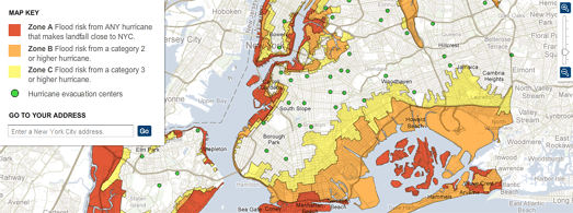
The New York Times’ New York City Hurricane Evacuation Zones Google Map shows the three evacuation zones in New York.
The zones are based on the strength of the hurricane making landfall. New York is preparing for the threat of storm surges with the closure of the entire public transportation system.

Climate Central has created a Google Map showing the areas in lower Manhattan, New Jersey and Brooklyn that are most at risk of storm surges from Hurricane Irene.
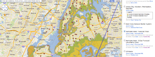
Yesterday Google released their Crisis Response 2011 Hurricane Season Google Map. Today they have created a map just for New York City: 2011 Hurricane Irene New York City.
The New York City map shows the forecasted track of Hurricane Irene as well as the evacuation zones and evacuation centers. It is also possible to view additional layers on the map showing:
- Storm Surge Probabilities
- The Red Cross National Shelter System
- Cloud Imagery
- Evacuation Routes

 ) doesn’t show much, but if you switch to Street View mode you’ll see Garrido pull out of his driveway and follow the Street View car down the road.