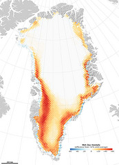
 NASA Earth Observatory has a map showing the record melt of Greenland’s ice cap in 2010, during which the melt started earlier and lasted longer than usual. “This image was assembled from microwave data from the Special Sensor Microwave/Imager (SSM/I) of the Defense Meteorological Satellites Program. Snow and ice emit microwaves, but the signal is different for wet, melting snow than for dry. Marco Tedesco, a professor at the City College of New York, uses this difference to chart the number of days that snow is melting every year. This image above shows 2010 compared to the average number of melt days per year between 1979 and 2009.”
Sign up for imagery update alert
Users in the Google Earth forum often ask about the age of satellite imagery and when the content will be updated. While we aren’t able to tell you in advance when our imagery will be updated, we can now notify you after new images are added to an area that you’re interested in.
With our Follow Your World application, you can register points on the globe and we’ll send you an email update whenever the imagery is updated there.
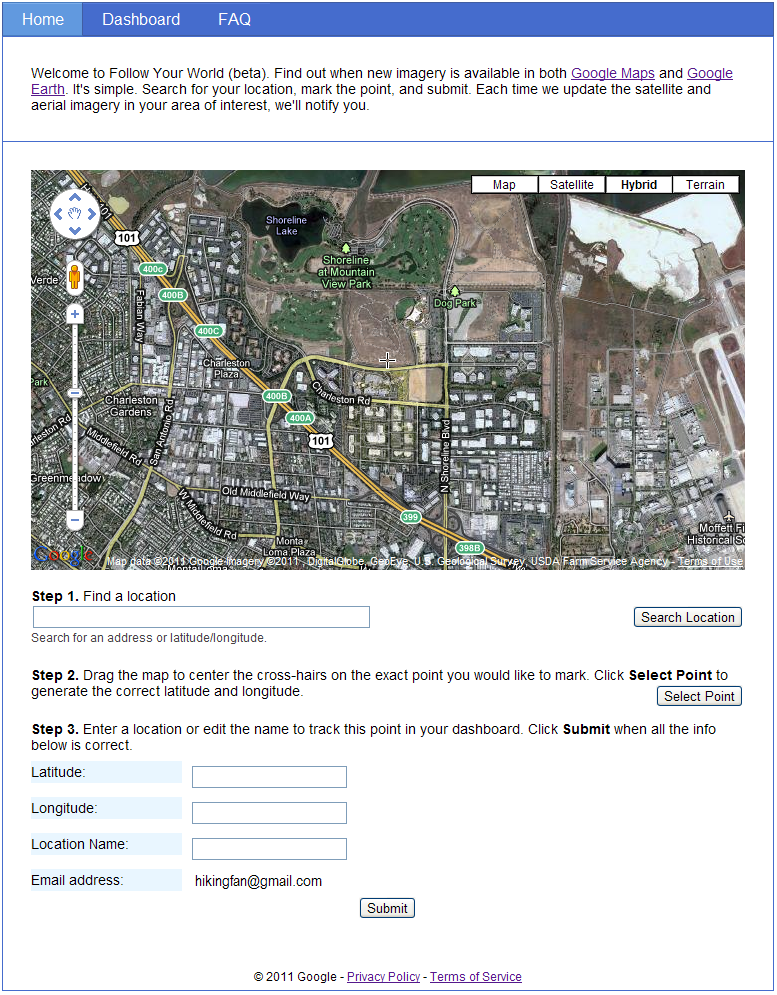
In just three easy steps, you can add points such as your hometown, your college football stadium, or just about any place on Earth. And since Google Earth and Google Maps share the same imagery, this tool is equally handy for enthusiasts of both products. Follow Your World also provides a handy dashboard to manage your subscriptions.
Whether you’re an armchair geospatial enthusiast, or you frequently use aerial imagery from Google Earth or Google Maps in your work, we invite you to give this new app a try so you’ll be the first to know.
Off to the 2011 GeoDesign Summit
![]() Just like last year, I’m headed off to the GeoDesign Summit to start the year. I’m looking forward to hearing how things have changed in the 12 months since we last sat in Jack’s new building, but I’m not sure I’m that hopeful.
Just like last year, I’m headed off to the GeoDesign Summit to start the year. I’m looking forward to hearing how things have changed in the 12 months since we last sat in Jack’s new building, but I’m not sure I’m that hopeful.
As with most things when you involve those in a University setting, it starts getting way too complicated to implement in the real world (and by real word I mean a situation where you don’t have grad students to implement your every whim). For GeoDesign to be embraced in workflows, it needs to get more zen and more pragmatic. We’ll have to see if there is more engagement from the private sector this year to keep GeoDesign from falling into just something you learn in College and never use again (like Shakespearian Literature).
I’ve been prototyping using WeoGeo in GeoDesign workflows and I think there is some really great ways we can use hosted GIS services to help get faster feedback on designs.