New Google Earth Imagery

Google has just pushed out another update, and they’ve already pushed it completely out, as this imagery can already be found in Google Maps and in the official updated areas KML file. Thanks to GEB reader ‘Andreas’ for letting us know about it!
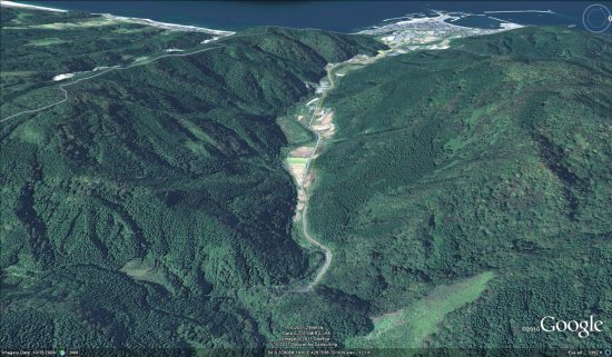
japan-imagery.jpg

The updated areas include:

  • Brazil: Many small patches across the country
  • Chile: Various areas
  • India: Mumbai
  • Iran: Various areas
  • Italy: Patches in the northern part of the country
  • Japan: Various northern areas
  • Namibia: Various areas
  • Pakistan: Central area
  • South Africa: Various areas
  • Sudan: Many areas in the southern part of the country
  • Switzerland: Large area just south of Bern
  • United States: Parts of California, Florida, Kentucky and Virginia
  • Zimbabwe: Various areas

A few other areas have been updated as well, but those are the main ones. To see all of the updates, simply load the updated areas KML file and check them out for yourself!

New Google Earth Imagery – January 24

It’s been over a month since the past update, but thanks to some sharp-eyed GEB readers (‘Andreas’ and ‘r m’), we’re now aware that Google has just pushed out a new update!

imagery.jpg

As is usually the case, you can use Google Maps to determine for sure whether or not a specific area is fresh. This new imagery isn’t in Google Maps yet, so you can compare Earth vs. Maps to see what’s new; the fresh imagery is already in Google Earth, but the old imagery is still in Google Maps. If you compare the two side-by-side and they’re not identical, that means that you’ve found a freshly updated area in Google Earth!

[UPDATED — 23-January, 5:08pm EST]

  • Canada: Manitoba and northwestern Ontario — thanks ‘Steven’
  • China: Takla-Makan desert and Tibet — thanks ‘Neutravo’
  • England: Various areas — thanks ‘Steven’
  • Ireland: Ballycotton, Castlebar, Kinsale — thanks ‘r m’
  • Norway: Maloy — thanks ‘Andreas’
  • Scotland: Various areas in the southwest area of the country — thanks ‘Dunk’
  • Spain: Catalonia and Zaragoza — thanks ‘Nacho’ and ‘Neutravo’
  • Ukraine: Pervomaisk and Sevastopol — thanks ‘Sean’
  • United States: Florida (Lakeland, Sarasota), Georgia (Macon, Augusta), Illinois (Champaign), Missouri (Branson and Springfield) and Ohio (Toledo) — thanks ‘Kevin’ and ‘Munden’

If you find any other updated areas, please leave a comment and let us know!

Defense Department Testing to Affect GPS Signals in Southeastern U.S.

FAA Flight Advisory Map

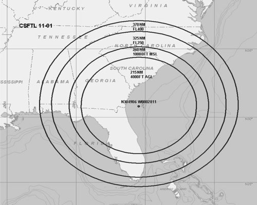
Engadget passes on a Federal Aviation Administration advisory (PDF) that, due to Defense Department testing, GPS signals may be “unreliable or unavailable” within several hundred miles of a point off the coast of Florida and Georgia for brief periods between January 20 and February 22, 2011. The advisory is aimed at pilots, but we can surmise that terrestrial GPS usage — admittedly less a matter of life or death than aviation — might be affected as well. The radius affected increases with altitude: 370 nautical miles (685 km) at 40,000 feet (FL400, 12,200 m), falling to 215 nautical miles (398 km) at 4,000 feet (1,220 m).