Playing GeoGames in Google Earth

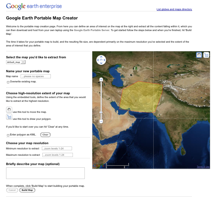
We’ve seen a lot of games built on top of Google Earth over the past few years, including some great ones such as GE War, Ships, Helicopters and the Apollo 11 Moon Lander.

Today we have a new game from CyberCity3D, who last month showed off a slick new map for Vixen’s L.A. Happy Hours. This latest game is part of their new site: GeoGames3D.com.

GeoGames1.jpg

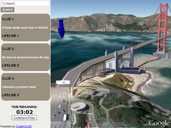
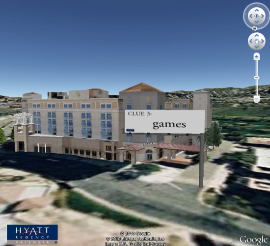
The scavenger hunt-style game itself isn’t too exciting, but it’s very well crafted. You use a variety of clues to search around the city for prize boxes. As long as you’re comfortable with the Google Earth controls, moving around to find the clues can be a fun little adventure. They also include “lifelines” to fly you there automatically if you get stuck.

The great part is that they’re offering real prizes to those that win, including some $5 Starbucks and Subway gift cards. They’re not huge prizes, but they’re a fun little reward for spending a few minutes playing a game!

GeoGames2.jpg

Head out to GeoGames3D.com and try their first game, titled “Globe Quest”. Be on the look out for more games coming from them soon, and you can join their Facebook Page to stay in the loop when new games are released.

Announcing Google Earth Enterprise 4.1

Back in August we announced Google Earth Enterprise 4.0. This version introduced the new Google Earth Portable Solution, and a Google Earth Android Client, for enterprise use. Since then, we’ve been speaking with numerous customers about the release, learning all about the compelling ways they’re using our portable and mobile technologies and listening to their helpful feedback. We’ve made additional developments based on that feedback, and today we’re pleased to announce an update to Google Earth Enterprise (GEE). The new version 4.1 brings with it:

  • 2D Map Cutting and 2D Map Portable Serving: Google Earth now supports cutting and serving 2D (Mercator) maps.
  • Google Maps API V3 on Google Earth Enterprise Solution: Developers can now use the Maps API V3 to build and serve mapping applications.
  • Customized search services for Google Earth: Search tabs on the portable server can be extended via Python search scripts that you bundle with the server for distribution.

Thanks again to all our customers and partners who provided us with great feedback over the past few months and we look forward to hearing more from you.
Posted by Dylan Lorimer, Enterprise Earth/Maps Product Manager

Take your own aerial photos with the Swinglet CAM

Over the past year, we’ve shown you a few of the amazing places where Frank has taken aerial photos with his kite, like Petite Tabac, BBQ Island and Manihi. The imagery is certainly stunning, as shown here in this image of Petite Tabac:

petite-tabac.jpg

However, if flying a kite doesn’t sound appealing to you, a company called senseFly has a product that might interest you — the swinglet CAM. It’s a remote controlled plane that somewhat resembles a B-2 Stealth Bomber, with a 12 megapixel camera attached to the bottom to capture images as you fly!

swinglet_cam.jpg

It also has some innovative features, such as the ability to fly a pre-programmed route based on GPS coordinates.

It’s hard to say what your typical image quality would be with a device like this, but the samples shown on their page are quite impressive, such as the image below:

swinglet-sample.jpg

Detailed pricing information isn’t available on their site, but they told me that the complete system is around $10,600 (USD). I certainly agree with gizmag that it’s not cheap. However, if you’re often needing high-quality aerial imagery, this is certainly a great option to consider.

For more, check out the video below to see it in action or check out their official site.