MapMyFITNESS and Google Maps API for Business

Being fit means moving and moving means going someplace. We created the MapMyFITNESS applications because we are passionate about living active lifestyles and we wanted a way to both track our progress and explore new activities. We wanted to help people experience this passion for themselves. As our community of MapMyFITNESS users has grown to over 9 million people, we have continually worked to make the applications easier to use and more effective at motivating people to keep moving, whether they’re elite athletes or people just getting started.

A key component to that mission has been our integration with Google Maps, which has made it easy for our users to find new routes or make their own, then share them with the rest of the MapMyFITNESS community. As one of the earliest Google Maps API developers, we noticed it was easy to incorporate the mapping functionality into our product. As we set about to completely rebuild our platform that launched earlier this month, our goal was to expand the ways users could take advantage of Google Maps’ latest API functionality. We’ve gone from tracking and sharing routes in our old platform to providing “Courses” in our new platform. Courses provide our users with real-time data like traffic patterns and temperature, and include “check-in” technology that helps them track workouts, share their progress, and compete in our new leaderboard against specific groups of people. They can compete with local clubs, friends, and most importantly against themselves and their own progress.

The Google Maps API allowed us to show the important information to our users in an easy to read format. Users can visit our site to find new cycling, running or walking routes by searching for the route while viewing it on the map. By using the Google Maps API were we able to incorporate the Street View API to create virtual tours of routes and the Elevation API to calculate how many feet you climb – and descend – during your workout. That familiarity, in addition to fantastic technology and features, makes the user experience both easier and more powerful.
Microsoft Bing Maps Takes the Fast Route to Efficiency

Microsoft Bing Maps team members Tom Barclay, Brad Clark and Ryan Tracy talk about how their work with Dell Data Center Solutions on their new microsite in Longmont, Colorado, enables them to deliver the world to the world — for less.

http://www.youtube.com/v/SDLc1di2tUQ?version=3&f=videos&app=youtube_gdata

The New Google Earth 6.1


Google Earth 6.1 has just been released, and it comes with a handful of very nice features. You can download the new version here.

Changes to “Places”
With our ever-growing collections of saved Places in Google Earth, they’ve added a few tools to help us keep them organized. If you have a folder full of places, you can now click on that folder and sort them all from A-Z. In addition, there is now a small search bow at the bottom of your “places” window that allows you to search within your saved places to find items.

Changes to Street View
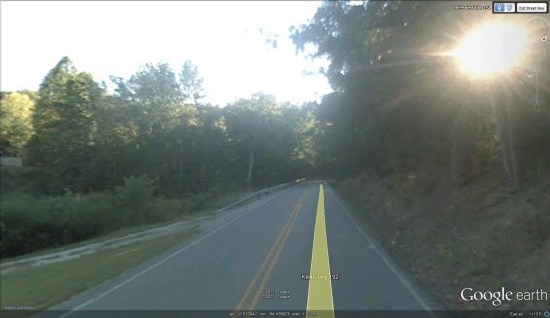
Late last year, Google added some big improvements to the Street View mode in Google Earth 6. They’ve now refined it a bit further by allowing you to single click to move to a new location (instead of requiring a double-click) and they’ve improved the zoom feature. Now you’re able to use the slider control on the right side of the screen to zoom in and out with much greater control. Street View in Google Earth also has a slightly wider field of view, similar to that found in Google Maps.


street-view.jpg 

New lengths in ruler
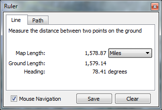
We just showed you some great ways to use the Google Earth ruler a few weeks ago, and it had a minor change with this update. When using the “line” tool, instead of just telling you the length of the line, it will show you the “map length” along with the “ground length” of the line, which can vary slightly.


map-length.png 

New fonts for street/place labels
It’s hard to tell exactly what they’ve done, but it appears the fonts have been reduced in thickness (un-bolded, sort of), but also increased slightly in size. In any case, they’re a bit easier to read.

Minor tweaks in the sidebar
Along with the changes to the “Places” section, they’ve revamped some of icons over there, and turned the (+) folder expansions into soft arrows, to make it look a bit less harsh.

New settings in “Tools –> Options”
You can now set the “Units of Measurement” to use your system default (rather than specifically choosing feet vs. meters)

“View –> Reset” menu option
This is still accomplished more easily with the keyboard, but you now have some options to reset your view with the menu. If you’d prefer to reset with the keyboard, you can press “n” to face north, “u” to reset to a top-down view, or “r” to reset both.

“Help –> Upgrade to Google Earth Pro…” menu option
A very minor addition; another bit of encouragement to upgrade to Google Earth Pro. Clicking this simply loads an informational page on what you’ll get in Google Earth Pro.

Updates in Google Earth Pro
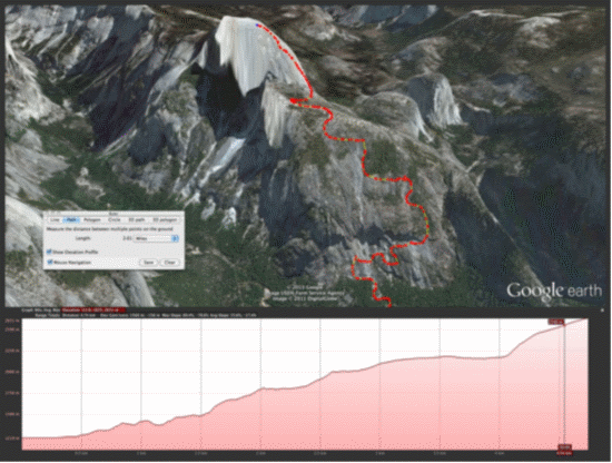
Speaking of GE Pro, 6.1 has brought some nice updates to that product on top of the updates listed above including enhancements to the printing layout, movie maker and better support for proxies and SSL certificates. They also tied the elevation profile into the ruler tool, saving a step when working with paths, as shown in the screenshot here. More details about the Google Earth Pro updates can be found on the Google Enterprise Blog.


elvaruler61.png 

All in all, it’s a solid update. Nothing groundbreaking, but lots of little enhancements to make the Google Earth experience better for every user.

Google Lat Long Blog