Google Earth 6.1: New features to explore your world


The Google Earth 6.1 update includes enhancements to make Google Earth easier than ever for both everyday users and business professionals.

Easier to use My Places
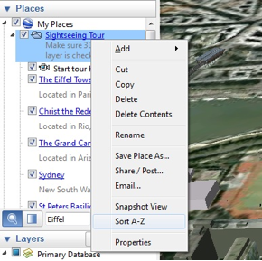
If you’re like me, your growing collection of maps in the My Places panel is getting a bit unwieldy. Every time I find a great new map or upload a new GPS track, it gets a little harder to find things. With this release, we’ve added a couple of new features to help you clean house a bit and find things more easily. First, we’ve added the ability to sort a folder – just right click on any folder and choose “Sort A-Z.” We’ve also made our My Places search feature easier to find; now all you have to do is type in the name of a map or a feature and it will highlight in the My Places panel.

You can now sort your My Places folders to improve organization.

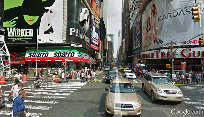
Improved Street View
Building on the improvements we made to the Street View experience in Google Earth 6, we’ve now added even more Street View features, including better zoom control through the slider tool and a wider field of view similar to Google Maps. You can now also navigate from one place to another with just a single-click of the mouse. These features make Street View in Google Earth more immersive, while performance improvements create a faster, smoother overall experience.

Street View in Google Earth now has a wider field of view.

Google Earth Pro
While these features are available to all of our users, much of the work we’ve done in Google Earth 6.1 benefits power users and professionals who use Google Earth Pro, including:

  • Enhanced print layout: Pro users can now include scale bars and directional arrows when printing, making it easy to include all relevant information in client presentations.
  • Simplified movie maker: It’s now easier to convert saved tours to video and record live actions from the 3D viewer to really bring your presentation to life.
  • Expanded data styling: Control up to 64 unique style attributes for imported datasets.
  • Improved networking infrastructure: Earth Pro 6.1 received a robust network update, which offers better support for network proxies and SSL certificates commonly found in corporate networking environments.
  • Combined elevation profiles and ruler tool: We know that sometimes distance is only one part of the equation. We’ve tied elevation profiles into the ruler tool, making it possible to take into account the entire 3D environment when measuring distance.

Combined ruler and elevation profile tool used to measure Yosemite’s Half Dome Peak.

We hope these enhancements make it even more fun and exciting to explore the planet, wherever you are in the world. Download Google Earth 6.1 to get started.

Speed up Google Earth

Some of you out there are running brand new, amazingly fast machines that can handle anything you throw at it and Google Earth consistently runs well. For the rest of us, though, we need to balance features vs. speed in order to keep things running smoothly.

With that in mind, here are some tips to help Google Earth run more smoothly on your computer.

DirectX vs. OpenGL (Windows only)

On Windows computers, you have a choice to run Google Earth in “DirectX” or “OpenGL” mode. You can change the setting from inside of the [Tools] –> [Options] menu, or start them separately from your main Start menu. There may not be much of a difference, but play with them and see what happens.

Disable some layers/places

If you’re running with a whole bunch of Layers and Places open, try turning a few off. I enjoy keeping the Blue Marble overlay on quite often, along with a handful of other layers (roads, borders, 3D buildings, etc). However, things speed up considerably if I turn all of that off.

3D buildings are one of the biggest performance hogs, simply because they generate a lot of data to be displayed, so turning them off will help quite a bit. On the other hand, if you’re wanting to find ways to improve 3D building performance, then disabling as many other layers as possible is your best move.

Anisotropic Filtering

Anisotropic filtering is one of those cool features in Google Earth that most people don’t understand. In short, it helps keep things sharp when you’re viewing imagery from a low angle. Here is an image from the anisotropic filtering Wikipedia entry, comparing it turned off (on the left) and on (on the right):

Anisotropic_compare.png

You can see that it certainly helps make things look better, but it also costs a bit of performance. Turning it off can help speed things up.

Antialiasing

Anti-aliasing is a technique used to smooth the edges of features in an image. In Google Earth, this is particularly noticeable on 3D models. For example, here is part of the Georgia Aquarium with Google Earth’s Antialiasing set to “medium” on the left and “off” on the right. You can clearly see how much it improves the appearance of the building, though turning it off will help things to run a bit more smoothly. You can turn it off in the main [Tools] –> [Options] menu.

aquarium.jpg

Terrain Quality

The entire globe in Google Earth is covered with a 3D terrain mesh. But adjusting the quality of that mesh, you can improve performance. Simply go to [Tools] –> [Options] and move the Terrain Quality slider further to the left.

Atmosphere

When zoomed out, Google Earth has a cool blue/gray atmosphere surrounding the earth. You can disable it by clicking on [View] –> [Atmosphere].

Water Surface

When Google Earth 5 was released, one of the big new features was the 3D ocean. Part of that new feature includes a realistic looking surface on the ocean. To disable that surface, go to [View] –> [Water Surface].

Cache

Google Earth keeps imagery in two types of caches to help improve performance. The Memory Cache holds imagery in your RAM, and is cleared each time you boot up your computer. The Disk Cache holds imagery on your hard drive for easier access. Incresing those numbers can help your performance. However, if you have a low amount of RAM or are low on hard drive space, you may be better off to decrease them a bit to give your computer a little more to work with.

None of these tips will make a huge difference by themselves, aside from any massive “Place” that you may have enabled, but added up they can make quite a difference. Play with some of the settings and see what happens.

Google Earth: Tracking hurricane speeds

In 2006,  a tool from Jeremy Cothran at the University of South Carolina that provided a ton of near real-time weather data from various sensors around the southeastern United States.

Jeremy has now taken that vast amount of data, and simplified it to highlight significant events among those sensors. In particular, it highlights wind gusts over 30 mph or wave heights over five feet. The result, when combined with other tools such as Google’s built-in satellite overlay, can be quite useful.

wind-speeds.jpg

The more significant events are shown using larger icons, making it easier to see where the heart of the action is. You can also view the data using Google Maps, but it loses the label styling and time slider functionality.