Google Earth 6.1: New features to explore your world


The Google Earth 6.1 update includes enhancements to make Google Earth easier than ever for both everyday users and business professionals.

Easier to use My Places
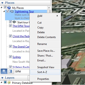
If you’re like me, your growing collection of maps in the My Places panel is getting a bit unwieldy. Every time I find a great new map or upload a new GPS track, it gets a little harder to find things. With this release, we’ve added a couple of new features to help you clean house a bit and find things more easily. First, we’ve added the ability to sort a folder – just right click on any folder and choose “Sort A-Z.” We’ve also made our My Places search feature easier to find; now all you have to do is type in the name of a map or a feature and it will highlight in the My Places panel.

You can now sort your My Places folders to improve organization.

Improved Street View
Building on the improvements we made to the Street View experience in Google Earth 6, we’ve now added even more Street View features, including better zoom control through the slider tool and a wider field of view similar to Google Maps. You can now also navigate from one place to another with just a single-click of the mouse. These features make Street View in Google Earth more immersive, while performance improvements create a faster, smoother overall experience.

Street View in Google Earth now has a wider field of view.

Google Earth Pro
While these features are available to all of our users, much of the work we’ve done in Google Earth 6.1 benefits power users and professionals who use Google Earth Pro, including:

  • Enhanced print layout: Pro users can now include scale bars and directional arrows when printing, making it easy to include all relevant information in client presentations.
  • Simplified movie maker: It’s now easier to convert saved tours to video and record live actions from the 3D viewer to really bring your presentation to life.
  • Expanded data styling: Control up to 64 unique style attributes for imported datasets.
  • Improved networking infrastructure: Earth Pro 6.1 received a robust network update, which offers better support for network proxies and SSL certificates commonly found in corporate networking environments.
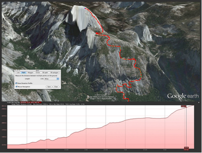
  • Combined elevation profiles and ruler tool: We know that sometimes distance is only one part of the equation. We’ve tied elevation profiles into the ruler tool, making it possible to take into account the entire 3D environment when measuring distance.

Combined ruler and elevation profile tool used to measure Yosemite’s Half Dome Peak.

We hope these enhancements make it even more fun and exciting to explore the planet, wherever you are in the world. Download Google Earth 6.1 to get started.

Explore new features at Garmin Connect

Relive every run, ride and other outdoor adventure at Garmin Connect. Now with new features to create workouts and courses.

http://www.youtube.com/v/M04mGDnEKG0?f=videos&app=youtube_gdata

The SqlGeometry with Microsoft SQL Server

I came across a curious error earlier today when attempting to use a SqlDataReader to read a column of geometry data from a SQL Server table:

System.InvalidCastException: Unable to cast object of type ‘Microsoft.SqlServer.Types.SqlGeometry’ to type ‘Microsoft.SqlServer.Types.SqlGeometry’

SqlGeometry to SqlGeometry… you’d think that would be a pretty easy cast, wouldn’t you? It turns out that this is a problem caused by a conflict between the spatial libraries used in SQL Server Denali compared to that in 2008/R2, and you’ll get this error depending on which version of Microsoft.SqlServer.Types.dll you use, and how you try to access geometry or geography columns from a datareader:

[php]
while (dataReader.Read())
{
// This works in SQL Server 2008/R2, but errors with Denali
SqlGeometry g = (SqlGeometry)dataReader.GetValue(0);

// This works in SQL Server 2008/R2, but errors with Denali
SqlGeometry g = (SqlGeometry)dataReader["GeomCol"];

// This works in Denali, but not in SQL Server 2008/R2
SqlGeometry g = SqlGeometry.Deserialize(reader.GetSqlBytes(0));

// This works in Sql Server 2008/R2/Denali
SqlGeometry g = new SqlGeometry();
g.Read(new BinaryReader(reader.GetSqlBytes(0).Stream));
}
[/php]

After a bit of digging around, it appears that using GetValue or square brackets notation [] to access a geometry/geography field in a SqlDataReader is hard-coded to load the 10.0 (SQL Server 2008) version of the Microsoft.SqlServer.Types library.

If you’ve got side-by-side installations of both SQL Server 2008/R2 and Denali (as I have), and try to reference the 11.0 (Denali) version of Microsoft.SqlServer.Types, you’ll therefore get an assembly mismatch when both versions of the library are loaded, which causes the slightly unhelpful error listed at the top of this post. Even if you’ve only got Denali installed, your code may still try to reference a (non-existent) 2008/R2 version of the Microsoft.SqlServer.Types.dll library, so you’ll get a different error instead:

Could not load file or assembly ‘Microsoft.SqlServer.Types, Version=10.0.0.0, Culture=neutral, PublicKeyToken=89845dcd8080cc91′ or one of its dependencies. The system cannot find the file specified.

The simplest way to resolve these errors is by changing the way you reference any geography/geometry (and, I imagine, hierarchyid) columns from your DataReader, as in the code example above. Alternatively, you can set up an assembly redirection in the application configuration file as explained here (about halfway down), which will allow you to correctly target the Denali version.

As per the What’s new in SQL Server Denali whitepaper, “… side-by-side installations of SQL Server Code-Named “Denali” CTP1 and CTP3 are not supported with existing SQL Server 2008 installations …”, so perhaps I only have myself to blame for this. Interestingly though, the person who raised this MS Connect issue, says that they have experienced exactly the same problem on a clean install of Denali CTP3. The response from Microsoft suggests that this may be due to older versions of the library being packaged with Visual Studio 2010, and also confirms that the problem will not be resolved prior to RTM of SQL Server Denali.

Strangely, I encountered another curious error a few months ago concerning version conflicts of Microsoft.SqlServer.Types. My CTP3 Management Studio Spatial Results tab does not plot curved geometries (selecting a CircularString or the result of BufferWithCurves etc. just produces a blank pane). I had originally assumed that, since this was only a CTP release, this feature had simply not been added yet. It turns out that curved geometries are supported in SSMS CTP3 Spatial Results tab but, if you have side-by-side SQL Server 2008 and Denali, this can corrupt this feature. I guess the reason is similar – that SSMS is somehow attempting to load the SQL Server 2008/R2 version of Microsoft.SqlServer.Types, which, of course, doesn’t support curved geometries.