Google Plugin for Eclipse 2.5

Since Google added SQL support to App Engine in the form of Google Cloud SQL, the Google Plugin for Eclipse (GPE) team has been working hard on improving the developer experience for developing App Engine apps that can use a Cloud SQL instance as the backing database.

They are pleased to announce the availability of Google Plugin for Eclipse 2.5. GPE 2.5 simplifies app development by eliminating the need for manual tasks like copying Cloud JDBC drivers, setting classpaths, typing in JDBC URLs or filling in JVM arguments for connecting to local/remote database instances.

GPE 2.5 provides support for:

  • Configuring Cloud SQL/MySQL instances
  • Auto-completion for JDBC URLs
  • Creating database connections in Eclipse database development perspective
  • OAuth 2.0 for authentication.

Configuring Cloud SQL/MySQL instances
App Engine provides a local development environment in which you can develop and test your application before deploying to App Engine. With GPE 2.5, you now have the ability to configure your local development server to use a local MySQL instance or a Cloud SQL instance for testing. When you choose to deploy your app, it will use the configured Cloud SQL instance for App Engine.

Auto-completion for JDBC URLs
GPE 2.5 supports auto-completion for JDBC URLs, and quick-fix suggestions for incorrect JDBC URLs.

Creating database connections in Eclipse database development perspective
The Eclipse database development perspective can be used to configure database connections, browse the schema and execute SQL statements on your database.

Using GPE 2.5, database connections are automatically configured in the Eclipse database development perspective for the Development SQL instance and the App Engine SQL instance.

You can also choose to manually create a new database connection for a Cloud SQL instance. In GPE 2.5, we have added a new connection profile for Cloud SQL.

GPE 2.5 now uses OAuth 2.0 (earlier versions were using OAuth 1.0)  to securely access Google services (including Cloud SQL) from GPE. OAuth 2.0 is the latest version of the OAuth protocol focussing on simplicity of client development.

Can’t wait to get started?
Download GPE here and write your first App Engine and Cloud SQL application using GPE by following the instructions here.

Google hope GPE 2.5 will make cloud application development using App Engine and Cloud SQL a breeze. We always love to hear your feedback and the GPE group is a great place to share your thoughts.
The SqlGeometry with Microsoft SQL Server

I came across a curious error earlier today when attempting to use a SqlDataReader to read a column of geometry data from a SQL Server table:

System.InvalidCastException: Unable to cast object of type ‘Microsoft.SqlServer.Types.SqlGeometry’ to type ‘Microsoft.SqlServer.Types.SqlGeometry’

SqlGeometry to SqlGeometry… you’d think that would be a pretty easy cast, wouldn’t you? It turns out that this is a problem caused by a conflict between the spatial libraries used in SQL Server Denali compared to that in 2008/R2, and you’ll get this error depending on which version of Microsoft.SqlServer.Types.dll you use, and how you try to access geometry or geography columns from a datareader:

[php]
while (dataReader.Read())
{
// This works in SQL Server 2008/R2, but errors with Denali
SqlGeometry g = (SqlGeometry)dataReader.GetValue(0);

// This works in SQL Server 2008/R2, but errors with Denali
SqlGeometry g = (SqlGeometry)dataReader["GeomCol"];

// This works in Denali, but not in SQL Server 2008/R2
SqlGeometry g = SqlGeometry.Deserialize(reader.GetSqlBytes(0));

// This works in Sql Server 2008/R2/Denali
SqlGeometry g = new SqlGeometry();
g.Read(new BinaryReader(reader.GetSqlBytes(0).Stream));
}
[/php]

After a bit of digging around, it appears that using GetValue or square brackets notation [] to access a geometry/geography field in a SqlDataReader is hard-coded to load the 10.0 (SQL Server 2008) version of the Microsoft.SqlServer.Types library.

If you’ve got side-by-side installations of both SQL Server 2008/R2 and Denali (as I have), and try to reference the 11.0 (Denali) version of Microsoft.SqlServer.Types, you’ll therefore get an assembly mismatch when both versions of the library are loaded, which causes the slightly unhelpful error listed at the top of this post. Even if you’ve only got Denali installed, your code may still try to reference a (non-existent) 2008/R2 version of the Microsoft.SqlServer.Types.dll library, so you’ll get a different error instead:

Could not load file or assembly ‘Microsoft.SqlServer.Types, Version=10.0.0.0, Culture=neutral, PublicKeyToken=89845dcd8080cc91′ or one of its dependencies. The system cannot find the file specified.

The simplest way to resolve these errors is by changing the way you reference any geography/geometry (and, I imagine, hierarchyid) columns from your DataReader, as in the code example above. Alternatively, you can set up an assembly redirection in the application configuration file as explained here (about halfway down), which will allow you to correctly target the Denali version.

As per the What’s new in SQL Server Denali whitepaper, “… side-by-side installations of SQL Server Code-Named “Denali” CTP1 and CTP3 are not supported with existing SQL Server 2008 installations …”, so perhaps I only have myself to blame for this. Interestingly though, the person who raised this MS Connect issue, says that they have experienced exactly the same problem on a clean install of Denali CTP3. The response from Microsoft suggests that this may be due to older versions of the library being packaged with Visual Studio 2010, and also confirms that the problem will not be resolved prior to RTM of SQL Server Denali.

Strangely, I encountered another curious error a few months ago concerning version conflicts of Microsoft.SqlServer.Types. My CTP3 Management Studio Spatial Results tab does not plot curved geometries (selecting a CircularString or the result of BufferWithCurves etc. just produces a blank pane). I had originally assumed that, since this was only a CTP release, this feature had simply not been added yet. It turns out that curved geometries are supported in SSMS CTP3 Spatial Results tab but, if you have side-by-side SQL Server 2008 and Denali, this can corrupt this feature. I guess the reason is similar – that SSMS is somehow attempting to load the SQL Server 2008/R2 version of Microsoft.SqlServer.Types, which, of course, doesn’t support curved geometries.

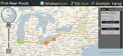
Azure SQL 2008 – Bing Maps – Near Route Demo

Azure SQL 2008 – Bing Maps – Near Route Demo

After the announcement http://bingmapswatch.blogspot.com/2010/03/bing-maps-sql-azure-support-april-2010.html that Azure SQL 2008 was implmenting Spatial Support (Geography and Geometry) this now enabled.

This is an example of combining, Windows Azuew, SQL Azure, Silverlight and Bing Maps to produce a find along a route example

Windows Azure SQL 2008 Bing Maps Find Near a Route
Finding Petrol (Gas) Stations along a route (Boston to Chicago) within 1km (1000m) of the route.

The code inside Azure SQL 2008 doing this is

@myGEOM is the lat and lng (x1,y2)+(x2,y2) start and end points for the route
@myBuffer is the buffer distance (1000m default)
@myRoute is the (xy,xy,xy,xy) of the enitre route creating a polyline
This polyline is then buffered creating a polygon (area) around the route.
SQL 2008 Azure then uses Geoproccessing 'Buffer' and 'Intersect' to pull-out
any points (gas stations in this example) and then displays the points as markers
on bing maps

code:

 CREATE PROCEDURE [FindNearRoute] @myGEOM nvarchar(MAX), @myBuffer int
AS
   --Create the Buffer
   DECLARE @myRoute geography;
   SET @myRoute = @myGEOM;

   DECLARE @SearchArea geography;
   SET @SearchArea = @myRoute.STBuffer(@myBuffer);

   --Return all POI in the search area
   SELECT Lat, Lon, Name
   FROM PetrolStations
   WHERE (@SearchArea.STIntersects(GEOM)) = 1

Live Example (Silverlight required)
http://talkingdonkey.cloudapp.net/BM-SL-FindNearRoute/Default.htm

There is also a zip file (BM-FindNearRoute.zip) with all the source code required to create your own find near a route example.

Source
http://johanneskebeck.spaces.live.com/blog/cns!42E1F70205EC8A96!12533.entry