Mappoint 2011 NA is released!

As of  March 1st, 2011

MapPoint 2011

is now officially released!

The MapPoint Product Home page has been updated and a trial download for MapPoint 2011 North America is now available. I hear the team is now working hard to get MapPoint 2011 Europe out the door.

After two releases with significant changes (MapPoint 2009 and MapPoint 2010) this release focused primarily on the #1 customer request which is data updates. As such there are 88,000 additional miles of roads. Updates are in the US, Canada, Mexico and Puerto Rico.

Larry Peterson on the MapPoint team at Microsoft writes —

This year we focused on updating our mapping data which is the #1 requested feature. With the 2011 version, you get 1.9 million points of interest (not only updated from 2010 but it was only 1.7million so many more have been added). There are also 88,000 additional miles of navigable roads in 2011 over 2010. That is pretty huge – equivalent to over 15 coast to coast round trips driving San Francisco between New York City.

Product development takes time and release cycles change for a variety of reasons. We’re ultimately committed to delivering top quality to our customers and this is what drives all efforts behind the product.
Fusion Tables for Volunteered Geographic Information (VGI)

Over the years, we’ve seen a handful of people and companies create massive images to be seen in Google Earth. One of the most famous was the Maxim magazine cover in 2006, but we’ve also seen advertising companies that focus on Google Earth as a way to show off their clients ads.

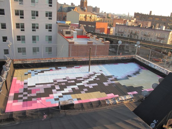
Today we’ll show you Molly Dilworth, who creates giant murals on top of buildings with the intent of being seen in Google Earth. Molly uses only discarded paint, and simply uses the physical surface of the roof to determine the shape of the painting. The end result is a pretty cool work of art, as seen here:

molly-manhattan.jpg

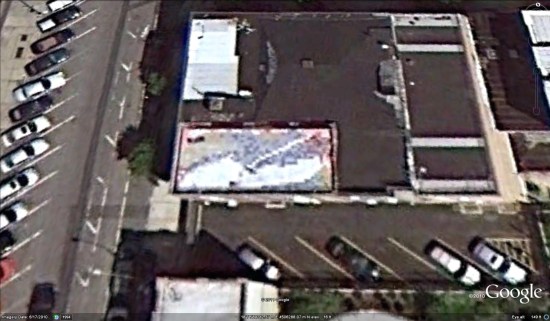
The problem that Molly faces, as does anyone that creates artwork intended for Google Earth, is that you never know when your images might appear online. In Molly’s case, it seems only one of her pieces of artwork is in Google Earth so far, and sadly it didn’t get captured especially well by the satellite.

molly-ge.jpg

If you’d like to view that mural in Google Earth, just use this KML file.

Fortunately, as Google Earth continues to improve the quality and speed of their updates, and Molly continues to create more of these murals, we’ll likely start seeing some appear very nicely in Google Earth in the near future.

Electric vehicle charging stations on Google Maps

At Google, we’ve been supporting environmentally-friendly cars through initiatives such as RechargeIT, an effort to accelerate the adoption of electric vehicles. As consumers embrace electric vehicles, we’ve also been adding information to Google Maps over the past few months to help users find charging stations. Just search on Google Maps for “ev charging station” plus the appropriate area, for example, “ev charging station near mountain view ca.”

We’d like to continue adding more charging stations to Google Maps, so we’re excited that our friends over at the the U.S. Department of Energy’s National Renewable Energy Laboratory (NREL) are working to make more data available.

NREL has launched the GeoEVSE Forum to help develop a detailed, accurate database of electric vehicle charging stations. We’ll be adding more EV charging locations to Google Maps as their database, and others, are updated. As always, you can use the Report a problem tool to inform us of any corrections.

If you represent an automaker, an electric vehicle charging station manufacturer or installer, an EV consumer group or any other interested party, you can join the GeoEVSE Forum by visiting this site.

We look forward to adding even more information to Google Maps to help you recharge your electric vehicle. Happy green driving!