How to use Google Earth as a source of geocoding!

I would like to share with you simple hint – How to use Google Earth as a geocoding tool.
You should have list with addresses and names of the points in Microsoft Exel file.
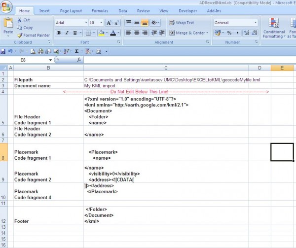

.KML format have couple of structures and one of them is:

[php]
<?xml version="1.0" encoding="UTF-8"?>
<kml xmlns="http://earth.google.com/kml/2.1">
<Document>
<Folder>
<name>
</name>
<Placemark>
<name>
</name>
<visibility>0</visibility>
<address><![CDATA[ ]]></address>
</Placemark>
</Folder>
</Document>
</kml>
[/php]

So we should take the name of the point and the address and we are putting it in this frame structure.
To do this we have to create simple macro which will create .KML file with the names and the addresses from our Microsoft Excel file.

[php]
Sub generateKML()

‘ GenerateKML Macro
‘ Macro recorded 27/02/2010 by ipt

‘ Set file details
Set filePath = [File_details!C2]

‘ Set document name
Set docName = [File_details!C3]

Open filePath For Output As #1

‘Write header to file
outputText = [File_details!C5] & docName & [File_details!C6]
Print #1, outputText

‘Start to loop through stations
For Each cell In [Data!A2.A50001]

pmName = cell.Offset(0, 0)
pmAddress = cell.Offset(0, 1)

If pmName = "" Then
Exit For
End If

‘Create a placemark
outputText = [File_details!C8] & pmName & [File_details!C9] & pmAddress & [File_details!C10]
Print #1, outputText

Next

‘Write footer to file
outputText = [File_details!C12]
Print #1, outputText

Close #1


End Sub
[/php]

We are creating two sheets – Sheet “data” – is where we have to paste the names and the addresses
The second Sheet is called “File_Details” and in this sheet we should describe the structure of the .KML file.
We are describing output file name and directory also.
The macro will Loop thru the record set from “Data” Sheet and it should Save data as .KML file.
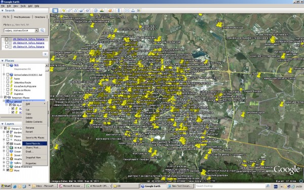
When you open the file with Google Earth it will start geocoding. For approximately 2500 POI – raw addresses with removed fullstops it took 30 minutes to geocode
1875 POI’s

To get the geocoded data you have save your file as .KML from Google Earth in specific directory.
After that you opening saved file with Microsoft Excel.
Microsoft Excel will ask you to open this file as an .xml table(picture)
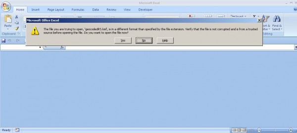
And opening the file you should see something like:
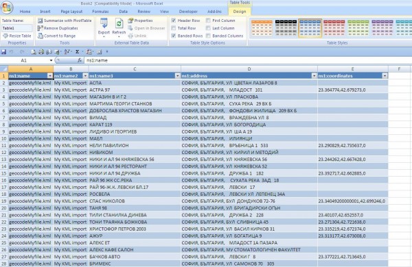

Copy POI and coordinates and bring them back in Microsoft Excel by “Paste special as value”.
Ugly Bug That Nuke Your Listing in Google Places


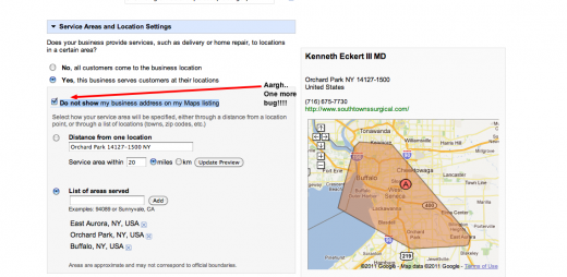
There is a reported service area bug in the Google Places Dashboard that has an easy work around but terrible results if you aren’t aware of it. (Thanks to Steve King of Simpartners for also highlighting the issue to me.)

When a business selects service area the “Do not show my business address on my Maps listing” check defaults to checked EVERY time you go in an edit your record. Thus it is necessary to deselect the check box or you will suffer the outcome associated with hiding your address. YOUR LISTING WILL DROP OFF THE FACE OF THE EARTH (As defined by Maps).


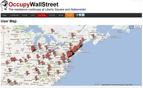
OccupyWallStreet – The Resistance Guided by Maps

occupywallst.org

The independent events, some simply community discussions, have been loosely tracked with Facebook,Google maps and links lists. Now, group meeting platform Meetup.com is assisting the protesters in their grassroots efforts.

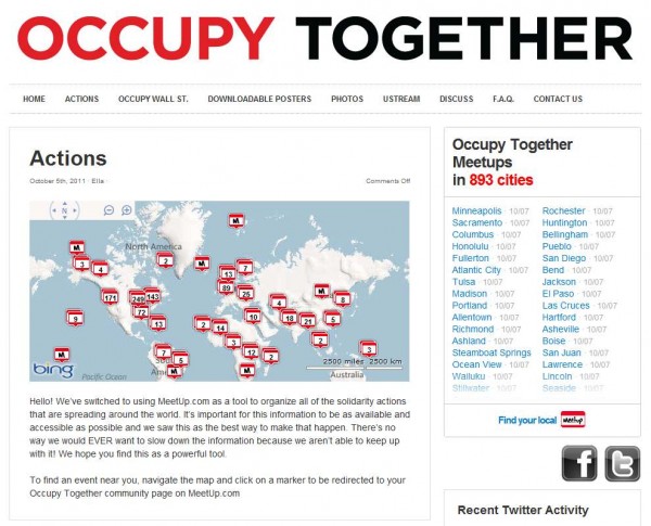
“We were contacted by the good people at Meetup.com, who got in touch because they heard we were in need of some technical assistance and advice,” says a blog post on Occupy Together, a site linked by Occupy Wall Street websites and protest publication The Occupied Wall Street Journal‘s Kickstarter page. “Little did we know we’d go from listing 4-5 locations in one night to receiving hundreds of emails in a day. We were slowing the flow of information because us volunteers weren’t able to keep up.”

Meetup previously worked with activist magazine Adbusters, an early organizer of the protests, on a project called “buy nothing day,” according to Meetup VP of community and strategy Andres Glusman. Adbusters made the introduction between Meetup and Occupy Together, which ultimately decided to use the platform’s free organizing tool, Meetup Everywhere.

Instead of continuing to maintain a list of protests, the site now features a Meetup widget showing 928 Meetups in 906 cities across the world, most added since Oct. 5 — and many with 0 participants.

Organizing on Meetup, a platform designed in many ways for grassroots organizing, has thus far been less common for “Occupy” protesters than organizing on Facebook. In most cases, the Facebook Pages trounce the new Meetup pages as far as attending participants go. The Occupy Wall Street Facebook Page has more than 130,000 Likes. It’s equivalent Meetup page has 23 “occupiers.” Similarly, Occupy San Francisco has 8,672 Likes and just 27 occupiers. A website called Daily Kos plotted the Facebook Pages on a Google Map (shown below) to make them easier to find.

Meetup has a couple of advantages from an organizing standpoint: a centralized landing page and a format focused on clear actions. It makes sense both the free platform and the unofficial organizers of protest information found it a good fit for Occupy Wall Street offshoots.

Scott Heiferman, Meetup’s CEO, has tweeted about his own involvement in the protests and is a backer of theThe Occupied Wall Street Journal‘s Kickstarter page.

Truth be told, both Facebook and Meetup are pretty chaotic as organization platforms. It’s hard to tell who, if anyone, will actually show up to any of the scheduled events. But that, according to Occupy Together, is part of the point.

“The GREAT thing about all of this, is that it’s completely in line with the whole idea of this decentralized movement,” the site says. “Any single person can start an action in their area, and where one stands up there will likely be another to join you.”

occupytogether.org