OpenStreetMap Skiing

A few weeks ago we showed you a handful of neat tools to help you enjoy the ski season a bit more, but we missed a big one — Skimap.org.

ski-trails.jpg

The main idea behind SkiMap is to allow users to upload maps from various ski resorts and share them with other users. Recently, however, they added a feature that uses the OpenStreetMap API to convert OSM data into KML vector ski maps. In just the past month, 940 ski maps were generated for use on the site!

The quality of the maps varies by location — European resorts are more fully mapped than US ones, and in the US they’re in better shape on the eastern half of the country. However, with the rate at which new ones are being added, your favorite ski area will probably look good on there very soon.

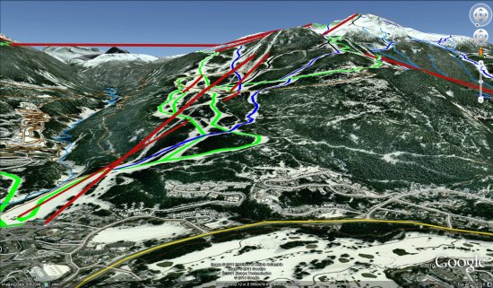
To see a good example of a ski area, check out Whistler Blackcomb. They have 67 different printed maps for Whistler, along with a handful of “OpenSkiMaps”. Here’s a KML file from one of them if you want to see it in Google Earth.

Mappa Mercia Demonstrating the Power of Open Street Maps

Earlier I came across a post on the mappa mercia site that really demonstrates the power of the collaborative nature of Open Street Map compared to other web mapping providers. One determined user has chosen to explore and map all the features in a particular UK postcode area, B72, in Birmingham. And when I say “map”, I don’t just mean the road network… the Open Street Map of this area now shows 3500 individual labelled residential properties, including gardens, almost 300 named retail units, 100 commercial buildings, together with all the normal OSM details of bus stops, litter bins etc. The level of detail in the resulting map is remarkable.

For reference, here’s a screenshot from Bing Maps’ roadmap view of a small area in the B72 postcode area:

image

Here’s Google Map’s, marginally more detailed, view of the same area:

image

And, largely based on the efforts of one person, here’s the Open Street Map version (click to enlarge):

image

Note the house numbers, additional detail of the shape of roads, boundaries of properties, every individual retail outlet listed separately… just brilliant.

This is only a small area of one country but, with the coordinated effort of talented users on the ground, it’s easy to see how OSM’s collaborative model can create more accurate, more up-to-date mapping information than the commercial data providers used by Google, Bing, Yahoo, and the like could possibly match. The future looks bright for mapping….

Local Government – Open Cycle Journey Planner

Local Government using CycleStreets based on OpenStreetMap OpenCycleMaps
Users can add their own – http://wiki.openstreetmap.org/wiki/Cycle_routes

West Sussex County Council Open Cycle Journey Planner

An Excellent addition to West Sussex County Council – Find your quietest journey to work, school or even for leisure.
Features:

  • Turn-by-turn directions
  • Journey time:
  • Distance:
  • Calories:
  • CO2 saving:
  • Quietness-o-meter
  • Route has very busy sections
  • Fly in Google Earth
  • GPS device export (GPX)
  • Elevation Profile.

Try your own journey by bicycle:
http://cyclejourneyplanner.westsussex.gov.uk/