The Hurricane Irene did more than $10 billion in damage


While Hurricane Irene didn’t strike the United States with as much force as many had predicted, it was still a substantial storm that claimed 54 lives and did more than $10 billion in damage.

GEB reader Noel has taken some of the imagery from NOAA’s Hurricane Irene Project Index Page and assembled them as image overlays in Google Earth. Some of the the imagery is quite striking, such as this image of a section of Highway 12 being washed away on North Carolina’s Outer Banks.


road.jpg 

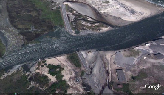
Highway 12 is the only road that connects Hatteras Island to the mainland, and this destruction has left 2,500 residents stranded on the island. There is an emergency ferry now in place to shuttle emergency personnel to and from the island, and no injuries have been reported.

Google Earth: Hurricane Irene

Hurricane Irene, which has already done some serious damage to Puerto Rico, was recently captured in stunning high resolution by NASA’s Terra satellite as it heads toward the east coast of the United States.

irene.jpg

You can view the image on NASA’s Earth Observatory website, or view it in Google Earth using this KML file. 
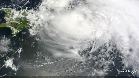
Be aware the KML is loading the full 5 MB file from NASA’s server, as it’s amazingly sharp, so it’ll take a few moments to load.

To track the Hurricane and view it’s forecasted track, turn on your Places layer and an icon will appear over the Hurricane. Clicking that icon will give you access to details about the Hurricane, along with historical data and various projected paths.

See also New York Times Hurricane Irene Tracking Map

Now You Can See the Weather in Google Maps

Whether you’re organizing a trip overseas or a picnic at a local park, knowing the weather forecast is a crucial part of the planning process. Today, we’re adding a weather layer on Google Maps that displays current temps and conditions around the globe, and will hopefully make travel and activity planning easier.

To add the weather layer, hover over the widget in the upper right corner of Google Maps and select the weather layer from the list of options. When zoomed out, you’ll see a map with current weather conditions from U.S. Naval Research Lab. And, if you look closely, you can also tell if it’s day or night around the world by sun and moon icons.

Enabling the weather layer also gives you an instant weather report for friends and family living around the world. For example, it looks like my family in London isn’t experiencing the best summer weather right now:

Weather near London, UK

Clicking on the weather icon for a particular city will open an info window with detailed data like current humidity and wind conditions, as well as a forecast for the next four days. Below is the upcoming forecast for my location in wintertime Sydney, which seems to have the similar weather as London!

Changing the units of wind speed (Mph/KMph) and temperature (F/C), and enabling or disabling the clouds (when you’re zoomed out), can also be done from the left-hand panel.

Weather left hand panel

Get started now and check out the weather layer here.