Garmin eTrex 20 handheld GPS (released in late September 2011)
The New Bing Maps Features
Coming back after the holiday season with a lot of energy, the Bing Maps team kicked off 2012 with releases of a new routing engine and the WPF control. Today–only 2 weeks later–we are now announcing several new features in the Bing Spatial Data Services and the Bing Maps Account Center. New features include a data source for traffic incidents, the ability to find points of interest (POI) along a route, wildcard-searches in your POI, incremental updates of POI data sources, improved reporting and more. Happy New Year! Are you feeling the love? ![]()
The Bing Spatial Data Services provide a REST interface that allows you to geocode or reverse-geocode your own POI data sources in batch-mode, manage these data sources and query your own or some public POI data sources that Bing Maps provides in a spatial context.
In this release, we added the following features:
- Incremental Upload – Your own data sources now support incremental updates by setting the parameter ‘loadOperation’ in the Data Source Management API to ‘incremental’. So, once you’ve uploaded a data source of X number of locations into the Spatial Data Service, if you just want to add a few records you can just send those few records. We’ll handle the add and update functions for you!
- Wildcard Searches – New Query Options support wildcard searches through filter criteria. Let’s say you want to query your data source to find the nearest locations around a point AND you want to filter the results based on the beginning or end of a keyword. For example, let’s say you have a “Store Manager” field in your data source. You can look for said manager by last name, “%Smith” or first name “John%” so you get all the Smiths or Johns within a region.
- Traffic Incidents – Traffic Incidents for North America are now available as a public POI data source and can be accessed through the Query API. Now the traffic incidents you see on Bing Maps are available to you in your applications via a spatial query.
- Find Near Route – The Bing Spatial Data Service supports now an additional spatialFilter which allows you to search for POI along a route. This is a game changer. Let’s say you’re a coffee company and you want to empower your users to have the ability find all your locations along their drive from, say Seattle to San Francisco…now you can! The Find Near Route Feature allows you to spatially query the points you’ve uploaded into SDS within a 1 mile buffer of your route.
http:// spatial.virtualearth.net /REST/v1/data/
439698230d90496596083f3fe7aafeb2/
TrafficIncidents/
TrafficIncident
?key=[YOUR_BING_MAPS_KEY]
&$format=json
&jsonp=callbackFindTrafficIncidentsNearRoute
&spatialFilter=nearRoute(‘47.678558349609375,-122.13098907470703’,
‘47.60356140136719,-122.32943725585937’)
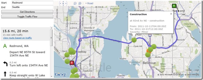
You will find a complete sample using the Bing Maps AJAX Control version 7 for visualization, the DirectionsManager class for driving directions, the TrafficLayer class for traffic-flow information and the Bing Spatial Data Services for traffic-incident information along a route here. Alternate versions of the SDK are available in PDF and .chm format, as well.
Note: Neither the Wildcard-search nor the spatial-filter ‘nearRoute’ are supported with the public data sources NAVTEQNA and NAVTEQEU.
The Bing Maps Account Center is the portal through which you can find information for development with Bing Maps, and also manage your account. It contains links to interactive and traditional SDKs, a facility to generate Bing Maps Keys, a web user interface to manage your own POI data sources and a reporting service through which you can retrieve statistics about your Bing Maps usage.
In this latest release we added the following features.
- Additional data validation has been introduced for the upload of your own POI data sources.
- Before it was already possible to add and edit records in a data source that you uploaded through the portal. You can now also download and delete data sources.

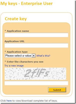
- Image capturing adds now additional security during the generation of Bing Maps Keys.
- Additional reports have been added to provide more details on the use of specific Bing Maps Keys.
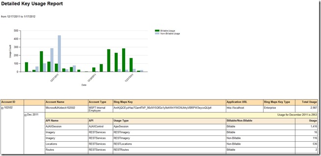
We certainly hope you’re feeling special (and spatial!). We’re investing quite a bit of energy into Bing Maps and hope to see some killer apps.
The New Google Earth 6.2
We’re taking bird’s eye view to a whole new level with the latest version of Google Earth, released today. With Google Earth 6.2, we’re bringing you the most beautiful Google Earth yet, with more seamless imagery and a new search interface. Additionally, we’ve introduced a feature that enables you to share an image from within Google Earth, so you can now simply and easily share your virtual adventures with family and friends on Google+.
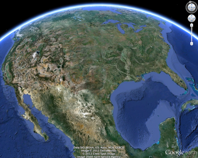
The Google Earth globe is made from a mosaic of satellite and aerial photographs taken on different dates and under different lighting and weather conditions. Because of this variance, views of the Earth from high altitude can sometimes appear patchy.
Today, we’re introducing a new way of rendering imagery that smoothes out this quilt of images. The end result is a beautiful new Earth-viewing experience that preserves the unique textures of the world’s most defining geographic landscapes—without the quilt effect. This change is being made on both mobile and desktop versions of Google Earth. While this change will appear on all versions of Google Earth, the 6.2 release provides the best viewing experience for this new data.
Share your explorations with Google+
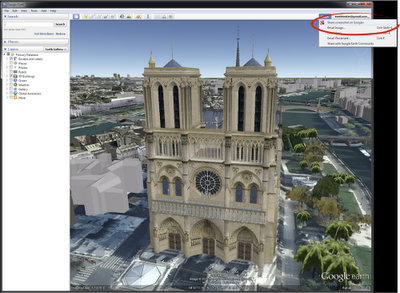
Google Earth is a great way to virtually explore the globe, whether revisiting old haunts or checking out a future vacation spot. With the Google Earth 6.2 update, we’ve added the option to share a screenshot of your current view in Google Earth through Google+. If you’ve already upgraded to Google+, you can share images of the places you’ve virtually traveled to with your Circles, such as family, friends or your local hiking club. To try this new feature, simply sign in to your Google Account in the upper right hand corner of Google Earth and click “Share.” Images of mountains, oceans, deserts, 3D cities, your favorite pizza shop on Street View—you can now experience all these amazing places around the world with people on Google+.
We’ve also made some updates to the search feature in Google Earth. Aside from streamlining the visual design of the search panel, we’ve enabled the same Autocomplete feature that’s available on Google Maps. We’ve also introduced search layers, which will show all the relevant search results (not just the top ten), so now, when looking for gelato in Milano, you can see all the tasty possibilities. Finally, we’ve added biking, transit and walking directions, so if you’re itching for a change of scenery or looking for a new route for your regular commute, you can now use Google Earth to generate and visualize all your options.
via: Google Lat Long blog
