Flooding in Queensland, Australia

Earth Observatory: Flooding in Australia: Rockhampton, QLD

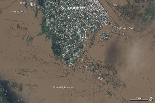
NASA’s Earth Observatory has a number of high-resolution satellite images of the floods in Queensland, Australia.

Nearmap managed to get an even closer look at the flooding, with two-centimetre-resolution imagery taken on January 13 and 14. ABC News (Australia) has a very neat infographic where you can slide between photos of the flooded areas and photos taken before the flooding. Flood imagery is available directly on Nearmap’s website, where you can select aerial imagery by date for comparison. More on the Nearmap images from the Brisbane Times. Via Google Maps Mania, @HodderGeography and Slashgeo.

Via Google Maps Mania: Above Photography’s aerial photography of the floods.

Google also has some map resources. Some links from Google Maps Mania.

Speaking of OpenStreetMap

Last month, it was announced that OpenStreetMap would be getting its hands on Microsoft’s aerial imagery. (One way to make maps in OSM is to draw on top of aerial imagery. Yahoo’s imagery has been made available for that purpose, but it’s is incomplete and a bit dated.) The new Bing imagery is now available through Potlatch 2 — sooner than I expected. And Potlatch 2 is now available through the regular OpenStreetMap site: you have to hover over the “Edit” tab to select it from a pull-down menu.

I’ve spent the last two days playing with both — i.e., creating maps with Bing aerial imagery using Potlatch 2. While there are places where the Microsoft imagery does not offer any advantage over Yahoo’s, there are lots of places where Bing’s imagery is more recent and at higher resolution. And there are lots of places that now have imagery that is worth tracing over that did not before. Locations that were basically unmapped in OSM now have one less excuse. (To be sure, many places with good imagery had no maps as well, but that’s a differet issue — volunteers, government data import, whatever.)

Potlatch 2 is noticeably improved over the public alpha. There are definitely some areas in which it’s an order of magnitude better than the original Potlatch, but there are still some gaps — some tags I use a lot are now a lot harder to find, and line directions are invisible, so far as I can tell, on things other than one-way streets (think rivers). I don’t think it’s any less stable, so on balance I prefer using it to its predecessor.

Take your own aerial photos with the Swinglet CAM

Over the past year, we’ve shown you a few of the amazing places where Frank has taken aerial photos with his kite, like Petite Tabac, BBQ Island and Manihi. The imagery is certainly stunning, as shown here in this image of Petite Tabac:

petite-tabac.jpg

However, if flying a kite doesn’t sound appealing to you, a company called senseFly has a product that might interest you — the swinglet CAM. It’s a remote controlled plane that somewhat resembles a B-2 Stealth Bomber, with a 12 megapixel camera attached to the bottom to capture images as you fly!

swinglet_cam.jpg

It also has some innovative features, such as the ability to fly a pre-programmed route based on GPS coordinates.

It’s hard to say what your typical image quality would be with a device like this, but the samples shown on their page are quite impressive, such as the image below:

swinglet-sample.jpg

Detailed pricing information isn’t available on their site, but they told me that the complete system is around $10,600 (USD). I certainly agree with gizmag that it’s not cheap. However, if you’re often needing high-quality aerial imagery, this is certainly a great option to consider.

For more, check out the video below to see it in action or check out their official site.