Google Maps Mashups 7

John Harlin Live Google Map


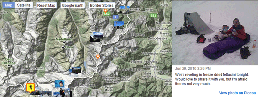
American author and adventurer John Harlin has set out on an epic journey to follow the entire Swiss border under his own power, a 2,000km odyssey with more than 170,000m of climbing. You can follow John’s journey on swissinfo.ch’s John Harlin Live Google Map.

The map shows John’s current position (at the time of writing he appears to be approaching the Matterhorn). The map also includes the amazing photographs that John has taken on his journey, links to John’s daily reports and some of the interesting features and points of interest that John is passing on his epic journey.


Browse the New York Times by Location
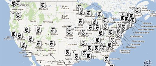

You can now browse the New York Times by location using the Longitude Google Map.

Geotagged news stories are displayed on the map with a Times ‘T’ logo. If you click on a map marker an information window opens with ten recent articles from the paper for that location.

Beneath the map you can view a list of locations from today’s edition of the paper. Clicking on these links will also open the relevant information window on the map.

Read Write Web

Vermont Flooding 2011 Google Map

Google Crisis Response has released a Vermont Flooding 2011 Google Map.

The map shows road and bridge closures in the state. It is also possible to overlay other layers on the map showing:

  • cloud imagery
  • USGS Real-time Streamflow
  • significant river flood outlook
  • Red Cross shelters
  • Vermont county borders

Build a Google Map

Build-A-Map is a new Google Maps creation tool to help users build visually appealing, functionally rich, and interactive maps with minimal effort.

Using the simple point-and-click interface users can create custom maps, publish the map on Build-A-Map’s servers and then simply embed it in their own website or application. You can view examples of Google Maps created with Build-A-Map on the demo page.

Currently Build-A-Map is in beta testing. You can sign up now to be an early user.

The Circle Count Top 100 Google+ Users Map

Everyone knows that the real purpose of social networks is to gauge how popular you are by the number of followers you can collect. Circle Count is a new website that is tracking the most followed people on Google+.

Circle Count lets you enter your own Google+ profile and find your own Circle Rank based on the number of your followers. You can even get a button for your website or blog that shows how many followers you have on Google+. The application also provides a nice graph that shows your follower history.

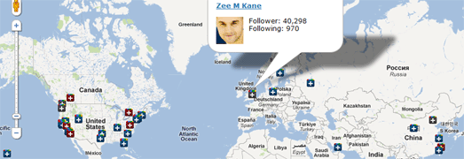
The Circle Count Top 100 Google+ Users Map is a Google Map of the top 100 Google+ users worldwide (based on the number of followers). The top 100 is actually a pretty good list of some of the most important and influential players on the internet (and Ashton Kutcher).

If you want to follow Mark Zuckerberg, Larry Page, Sergey Brin, Pete Cashmore, Vic Gundotra (the top 5) or connect with other important people on Google+ then this is a pretty good place to start.

Map of New York Evacuation Zones

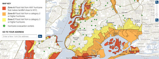
The New York Times’ New York City Hurricane Evacuation Zones Google Map shows the three evacuation zones in New York.

The zones are based on the strength of the hurricane making landfall. New York is preparing for the threat of storm surges with the closure of the entire public transportation system.

Climate Central has created a Google Map showing the areas in lower Manhattan, New Jersey and Brooklyn that are most at risk of storm surges from Hurricane Irene.

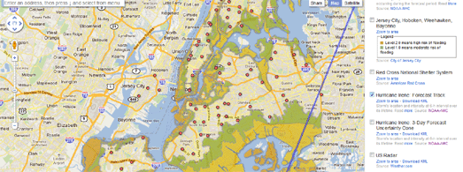
Yesterday Google released their Crisis Response 2011 Hurricane Season Google Map. Today they have created a map just for New York City: 2011 Hurricane Irene New York City.

The New York City map shows the forecasted track of Hurricane Irene as well as the evacuation zones and evacuation centers. It is also possible to view additional layers on the map showing:

  • Storm Surge Probabilities
  • The Red Cross National Shelter System
  • Cloud Imagery
  • Evacuation Routes

The New StreetPilot onDemand app: Affordable navigation

Rounding out Garmin’s diverse range of guidance options, our new StreetPilot onDemand app provides iPhone users convenient navigation for walking or driving when they need it, with an initial 99-cent download that includes 30 days of premium features. It is the first iPhone navigation app to include multimodal pedestrian routing, with bus and train transit schedules in many major cities. Additional premium features include spoken turn-by-turn guidance with street names, representation of 3D buildings and landmarks, traffic rerouting, photoReal Junction View and Google Local Search, among many others.

“Our new StreetPilot onDemand app is the perfect solution for anyone who occasionally needs navigation but still is looking for a premium experience and precise directions. There is nothing comparable in the App Store today,” said Dan Bartel, Garmin’s vice president of worldwide sales.

“By including multimodal pedestrian routing,” Bartel continued, “our new app is especially helpful for users in urban areas. The app seamlessly provides directions in the car and integrates public transportation when getting directions by foot.”

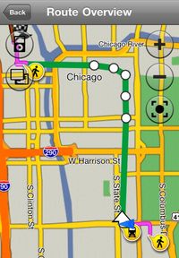
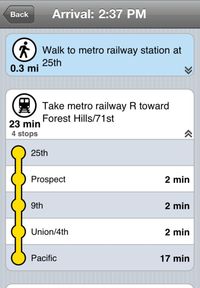
With the new multimodal pedestrian routing offered in StreetPilot onDemand, users can choose to integrate public transportation into their route. It is the first turn-by-turn iPhone navigation app that integrates train or bus schedules in the cities in which this service is available. Users can navigate to a destination from their current position (or set a different starting location), and the app provides turn-by-turn directions including a detailed itinerary of transit stops and instructions for walking to and from a bus or train stop. Beautifully rendered 3D buildings and landmarks make it even easier for pedestrians to find their destination.

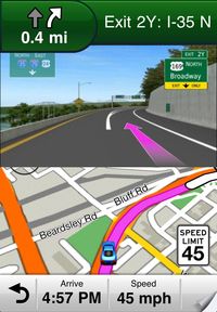
The app also is a comprehensive driving assistant that integrates many of the signature features for which Garmin is known. This includes spoken turn-by-turn directions, photoReal junction views that show a realistic depiction of the junction as well as lane guidance and real-time traffic information that automatically routes drivers around gridlock. Users can easily find points of interest using Garmin’s extensive database or Google Local Search. A new functionality suggests points of interest based on the users search history to provide faster and more relevant search results. The app also warns drivers when exceeding the speed limit and even provides an overview of the weather conditions at the destination, complete with a five day forecast.

The Garmin StreetPilot onDemand app integrates an extremely easy to use interface that is customized for the iPhone. It stores the maps and points of interest in the cloud, so they are always up-to-date. The comprehensive map options allow users to easily enable or disable features displayed on the map such as traffic information, 3D buildings and landmarks or points of interest.

Garmin StreetPilot onDemand is available in the App Store on iPhone or atwww.apple.com/appstore for $.99 and includes turn-by-turn, voice prompted navigation and traffic rerouting for 30 days in the United States and Canada. Users can extend this initial period by subscribing on a monthly ($2.99) or annual ($29.99) basis. Garmin offers a special introductory price of $19.99 for the yearly subscription from August 31, 2011, to September 14, 2011. Even without a subscription, users can still view maps, lookup points of interest and create routes. A subscription is required for turn-by-turn voice guidance with automatic off-route recalculation, real-time traffic information and multimodal pedestrian routing.

StreetPilot onDemand complements Garmin’s other newly announced automotive innovations that guarantee industry-leading navigation for every kind of driver and traveler. For a dedicated device that’s built to navigate with ease and efficiency, the recently announced 2012 nüvi® line adds robust features to Garmin’s flagship product line at affordable pricing (details at www.garmin.com/move). For iPhone users who want the nüvi experience, Garmin’s StreetPilot Onboard app dodges many of the pitfalls of other smartphone options. And for customers seeking in-dash guidance with the intuitive interface of a nüvi, Garmin is growing its OEM presence and building automaker partnerships to offer the most effective solutions.

Garmin pilot school

It’s that time of year.  The time when children are up early to wait at the bus stop. The time when groans about homework are echoing around the house. The time when yellow buses always seem to stop in front of you when you are late for work.  Yes, it is time for school.

But for a pilot, school (or at least the education) never really stops. We are always reading new information, or practicing approaches to refine our skills. Going into the school year and fall thunderstorm season is a great time for a little education. To that end I recommend Garmin’s online training course for the G1000. There is a VFR and IFR course available to help you get up to speed. Each training course has examples and demonstrations that walk you through the basic to the advanced. Visit flyGarmin.com for more information and pricing, and don’t forget the #2 pencil.