The News in the AJAX Map Control


The new modules add some very handy features, and they really show off the dynamic module loading capabilities of the AJAX 7.0 control by adding functionality when you need it, and getting out of the way when you don’t.

The new modules help you:

Calculate driving directions using the new Microsoft.Maps.Directions module. This makes it easier than ever to integrate driving, transit, and walking directions into your applications. Try it now (Interactive SDK).

Display a venue map using the Microsoft.Maps.VenueMaps module.  Venue maps show details of what’s going on inside malls, airports, and shopping districts.  Now you can show your customers not just where the building is, but exactly where your store is located inside.  This is one of the most popular consumer features on Bing Maps today and now you can make it part of your apps as well.Try it now (Interactive SDK).

Show current traffic on the map using the Microsoft.Maps.Traffic module.  Not only does this module make it easier to show traffic conditions, the new traffic overlays that shipped with v1.2 of the road map style look better than ever. Try it now (Interactive SDK).

But that’s not all, if you are doing advanced map development then we hope you will find these new features helpful:

Set polyline and polygon stroke dash. To further customize your shapes, use the new property strokeDashArray of the PolylineOptions Object and PolygonOptions Object.

New tile layer property and event. Ensure the best performance of your tile layer during animation by modifying the new animationDisplay property of the TileLayerOptions Object. Also, determine when your tile layer is fully downloaded using the new tiledownloadcomplete event.

New map options. For increased flexibility, new options showBreadcrumb, disableBirdseye, disablePanning, and disableZooming have been added to the MapOptions ObjectTry it now (Interactive SDK).

Before we sign off we wanted to acknowledge those who have seen the new “locate me” function implemented onBing Maps and asked when developers will be able to do the same.  The good news is that it’s already live today, just check out Get User Location functions.

Also, you might have noticed that in this post we are linking directly to features on the Interactive SDK.  We received lots of requests from developers for this feature when we released the iSDK back in May, and so we’ve redone the site to make that possible.
Maps APIs over SSL now available to all

As public WiFi becomes increasingly ubiquitous, we spend more and more of our time on shared networks. This can expose our personal data to third parties if the sites we access are not secure. Many sites use Google services to store and manage Google data. In response to this, Google is today announcing improved support for SSL (Secure Sockets Layer) across many APIs, and recommending that any application that manages user data switch to using SSL.

We want to ensure that applications using the Google Maps API are free to follow this recommendation. As such we are happy to offer free access to the Maps API v3, Static Maps API, and Maps API Web Services over HTTPS to all developers from today. To load the Maps API v3 over HTTPS, the API must be loaded from the hostname maps-api-ssl.google.com. For the Static Maps API and Web Services, please use maps.googleapis.com.

In addition to offering access over HTTPS, all of the Maps APIs (with the continuing exception of the Places API) will continue to be accessible over HTTP, and we recommend that sites that are using the API purely to display public data, such as store locations, continue to use HTTP for optimal performance.

Please also note that although SSL access is now available to all developers, the terms of the Maps API have not changed. If your site uses SSL because you charge for access to your application, or because your application is not publicly accessible to all users, you must still purchase a Maps API Premier license. For more information on Maps API Premier, please contact the Maps API Premier Sales team.

We hope this change assists in making your users feel safe and secure using your applications. If you have any questions or concerns about this change, please post to the Maps API v3, Static Maps API, or Web Services forum as appropriate for the service you are using.

Tools to help the armchair archeologist

A few weeks ago, we showed you a recent case of an “armchair archaeologist” who used Google Earth to discover almost 2,000 archaeological sites in Saudi Arabia.

With more and more stories like this popping up in the past few years, GEB reader “Will from the UK” has built a slick tool to help with the process.

In his words:

I enjoyed your post about the archaeologist who found interesting artifacts in Saudi Arabia using Google Earth. It got me thinking about how to do a systematic search of an area using GE.

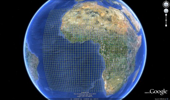
There are no tools in GE that help, other than the usual lines / placemarks. Marking an area out using lines is fairly tedious. A grid is a useful solution. I have seen grid generators online, but they tend to come and go, and you need to be online to use them.

I have created a spreadsheet that generates the KML code for a Latitude / Longitude grid. A grid allows a more systematic search to be conducted and also allows more people to take part in a search – the work can be divided between many volunteer searchers.

large-grid.jpg

The resulting spreadsheet is quite impressive, and it is a great way to divide up a large area for more precise searches.

You can download the Excel-based spreadsheet here. The spreadsheet is remarkably powerful, though it has a bit of a learning curve and a few limitations. Fortunately, Will has been generous enough to develop a User Guide (PDF) to help you get started.