Android Apps Over the 50MB Barrier


Android applications have historically been limited to a maximum size of 50MB. This works for most apps, and smaller is usually better — every megabyte you add makes it harder for your users to download and get started. However, some types of apps, like high-quality 3D interactive games, require more local resources.

So today, we’re expanding the Android app size limit to 4GB.

The size of your APK file will still be limited to 50MB to ensure secure on-device storage, but you can now attach expansion files to your APK.

  • Each app can have two expansion files, each one up to 2GB, in whatever format you choose.
  • Android Market will host the files to save you the hassle and cost of file serving.
  • Users will see the total size of your app and all of the downloads before they install/purchase.

On most newer devices, when users download your app from Android Market, the expansion files will be downloaded automatically, and the refund period won’t start until the expansion files are downloaded. On older devices, your app will download the expansion files the first time it runs, via a downloader library which we’ve provided below.

While you can use the two expansion files any way you wish, we recommend that one serve as the initial download and be rarely if ever updated; the second can be smaller and serve as a “patch carrier,” getting versioned with each major release.

Helpful Resources

In order to make expansion file downloading as easy as possible for developers, we’re providing sample code and libraries in the Android SDK Manager.

  • In the Google Market Licensing package, an updated License Verification Library (LVL). This minor update mostly adds the ability to obtain expansion file details from the licensing server.
  • From the Google Market APK Expansion package, the downloader service example. The library makes it relatively simple to implement a downloader service in your application that follows many of our best practices, including resuming downloads and displaying a progress notification.

Because many developers may not be used to working with one or two large files for all of their secondary content, the example code also includes support for using a Zip file as the secondary file. The Zip example implements a reasonable patching strategy that allows for the main expansion file to “patch” the APK and the patch file to “patch” both the APK and the main expansion file by searching for asset files in all three places, in the order patch->main->APK.

Expansion File Basics

Expansion files have a specific naming convention and are located in a specific place for each app. As expansion files are uploaded to the publisher site, they are assigned a version code based upon the version of the APK that they are associated with. The naming convention and location are as follows:

Location: /Android/obb//
Filename: [main|patch]...obb
Example: /sdcard/Android/obb/com.example.myapp/main.5.com.example.myapp.obb

Expansion files are stored in shared storage. Unlike APK files, they can be read by any application.

Downloading and Using the Expansion Files

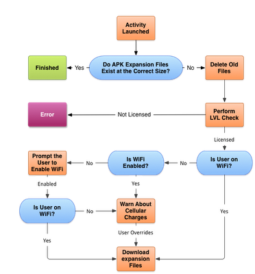
When the primary activity for the app is created, it should check to make sure the expansion files are available. The downloader library provides helper functions (for example the “Helpers” class in the code below) to make this easy.

boolean expansionFilesDelivered() {
    // get filename where main == true and version == 3
    String fileName = Helpers.getExpansionAPKFileName(this, true, 3);
    // does the file exist with FILE_SIZE?
    if (!Helpers.doesFileExist(this, fileName, FILE_SIZE, false)) {
        return false;
    }
    return true;
}

If the file does not exist, fire up the downloader service with DownloaderClientMarshaller.startDownloadServiceIfRequired(). The downloader will perform an LVL check against the server. This check will deliver the names of the files, file sizes, and the file URLs.

Once that check has been completed, it will begin downloading the files. You don’t have to use our download solution, but you might want to because we:

  • Include a notification UI that provides progress and estimated completion time in layouts customized for ICS and pre-ICS devices
  • Resume large files safely
  • Handle redirection with appropriate limits
  • Run in the background as a service
  • Pause and resume downloads when WiFi is not available

Enjoy! We can’t wait to see what kinds of things developers do with this! For more information about how to use expansion files with your app, read the APK Expansion Files developer guide.
GIS Cloud Removes Beta

Two months ago, GIS Cloud released a HTML5 client that was very slick.   My thoughts at the time:

The latest company to release a HTML5 client is GISCloud. While other visualization companies offer JavaScript maps as an option, GISCloud has made them default. By using the HTML5 Canvas element, GISCloud is rendering vector data right inside of the browser, with no plugin. Oh and you don’t need to use some sort of weird API to get it to work on iPhones or iPads. It just works, browsing 2 million features on my iPad in Safari without a native app. Crazy!

Well for those who view the Beta tag as something to avoid, GIS Cloud has now gone full production on their code.

Today’s GIS Cloud differs quite a lot from when it was first created, and so does the team as well. We have both grown and improved a lot; learned how to provide GIS users with what they need.  GIS Cloud got:

  • redesigned

  • much simpler to use and more intuitive

  • more focused on the map and data visualization

  • reborn with the HTML5 map engine

  • moved to Amazon Cloud

  • its very own platform for creating geo applications


There are some great demo’s on GIS Cloud’s website that really showcase how far HTML5 has come in supporting millions of features in a browser. Plus they work on iPad without needing to download a client app.

The SqlGeometry with Microsoft SQL Server

I came across a curious error earlier today when attempting to use a SqlDataReader to read a column of geometry data from a SQL Server table:

System.InvalidCastException: Unable to cast object of type ‘Microsoft.SqlServer.Types.SqlGeometry’ to type ‘Microsoft.SqlServer.Types.SqlGeometry’

SqlGeometry to SqlGeometry… you’d think that would be a pretty easy cast, wouldn’t you? It turns out that this is a problem caused by a conflict between the spatial libraries used in SQL Server Denali compared to that in 2008/R2, and you’ll get this error depending on which version of Microsoft.SqlServer.Types.dll you use, and how you try to access geometry or geography columns from a datareader:

[php]
while (dataReader.Read())
{
// This works in SQL Server 2008/R2, but errors with Denali
SqlGeometry g = (SqlGeometry)dataReader.GetValue(0);

// This works in SQL Server 2008/R2, but errors with Denali
SqlGeometry g = (SqlGeometry)dataReader["GeomCol"];

// This works in Denali, but not in SQL Server 2008/R2
SqlGeometry g = SqlGeometry.Deserialize(reader.GetSqlBytes(0));

// This works in Sql Server 2008/R2/Denali
SqlGeometry g = new SqlGeometry();
g.Read(new BinaryReader(reader.GetSqlBytes(0).Stream));
}
[/php]

After a bit of digging around, it appears that using GetValue or square brackets notation [] to access a geometry/geography field in a SqlDataReader is hard-coded to load the 10.0 (SQL Server 2008) version of the Microsoft.SqlServer.Types library.

If you’ve got side-by-side installations of both SQL Server 2008/R2 and Denali (as I have), and try to reference the 11.0 (Denali) version of Microsoft.SqlServer.Types, you’ll therefore get an assembly mismatch when both versions of the library are loaded, which causes the slightly unhelpful error listed at the top of this post. Even if you’ve only got Denali installed, your code may still try to reference a (non-existent) 2008/R2 version of the Microsoft.SqlServer.Types.dll library, so you’ll get a different error instead:

Could not load file or assembly ‘Microsoft.SqlServer.Types, Version=10.0.0.0, Culture=neutral, PublicKeyToken=89845dcd8080cc91′ or one of its dependencies. The system cannot find the file specified.

The simplest way to resolve these errors is by changing the way you reference any geography/geometry (and, I imagine, hierarchyid) columns from your DataReader, as in the code example above. Alternatively, you can set up an assembly redirection in the application configuration file as explained here (about halfway down), which will allow you to correctly target the Denali version.

As per the What’s new in SQL Server Denali whitepaper, “… side-by-side installations of SQL Server Code-Named “Denali” CTP1 and CTP3 are not supported with existing SQL Server 2008 installations …”, so perhaps I only have myself to blame for this. Interestingly though, the person who raised this MS Connect issue, says that they have experienced exactly the same problem on a clean install of Denali CTP3. The response from Microsoft suggests that this may be due to older versions of the library being packaged with Visual Studio 2010, and also confirms that the problem will not be resolved prior to RTM of SQL Server Denali.

Strangely, I encountered another curious error a few months ago concerning version conflicts of Microsoft.SqlServer.Types. My CTP3 Management Studio Spatial Results tab does not plot curved geometries (selecting a CircularString or the result of BufferWithCurves etc. just produces a blank pane). I had originally assumed that, since this was only a CTP release, this feature had simply not been added yet. It turns out that curved geometries are supported in SSMS CTP3 Spatial Results tab but, if you have side-by-side SQL Server 2008 and Denali, this can corrupt this feature. I guess the reason is similar – that SSMS is somehow attempting to load the SQL Server 2008/R2 version of Microsoft.SqlServer.Types, which, of course, doesn’t support curved geometries.