The Philippines hosts a Maps for preparation of natural disasters

This summer, a group of Filipino mapping enthusiasts organized an impressive series of Google MapUps throughout the Philippines. The events brought together Google Map Maker mappers across the country to map their communities in preparation of natural disasters. Located in the western Pacific typhoon belt, the Philippines is struck by an average of 20 tropical cyclones every year. As demonstrated by the 2009 Typhoon Ondoy (Ketsana) and Pepeng (Parma), which left much of Metro Manila underwater, the storms are both persistent and devastating.

The extensive series of Summer MapUps was organized by mappers from Luzon, Visayas and Mindanao after meeting at the Google Geo User Summit in Singapore. Following in the footsteps of super mapper Rally de Leon, who mapped extensively after the 2009 typhoons, this summer of MapUps was designed as a volunteer project for the Philippine Red Cross. The objective was to map places used during crisis, including health centers, government offices, gymnasiums and public schools used for evacuation.

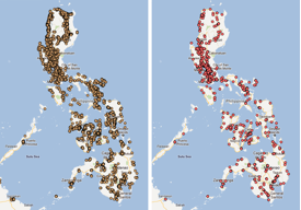
All of the schools (left) and hospitals (right) in the Philippines, as mapped on Google Map Maker.
The events kicked off in the Mindanao region, with MapUps in Malaybalay, Bukidnon and General Santos City. Northern Luzon followed with a MapUp in the City of Pines, Baguio City. Baguio City was hit by a devastating earthquake a decade ago, which took the lives of over a thousand people. Volunteers wanted to make sure that they tagged important places, such as evacuation relocation sites, that would help in rescue and relief.

MapUps in Iloilo City, Metro Manila, Zamboanga and Cebu City followed. Zamboanga mappers focused on Zamboanga Peninsula, one of the least mapped areas in the Philippines. The Cebu City volunteer mappers were geology students from University of the Philippines Visayas Cebu College. They enjoyed tagging, moderating and editing data, and vowed to continue mapping to complete the Cebu map.


Even though summer is over in the Philippines, we will still continue to add map data using Google Map Maker as an effort to help the Philippine Red Cross. If you are interested in hosting a MapUp in your neighborhood, or have other great mapping ideas, be sure to visit Map Makerpedia, which brings together lessons, tutorials and use cases from around the world.

Sweden is hiding “secrets” visible from space


• Some of their “military secrets” are visible on Google Earth, but not on their local mapping sites (Hitta.se and Eniro.se).

• Google uses imagery from Lantmäteriet to cover parts of the country, and Lantmäteriet sensors some sensitive areas.
• There are two main underground control centers for Sweden’s air force; one is visible in Google Earth, the other isn’t.
• The one that is visible is because Google is using imagery from DigitalGlobe for that part of the country, and they’re not censoring it.

Stefan goes on to point out something even more interesting — historical imagery of the obscured area from a few years ago clearly reveals the facility, and the imagery was also from Lantmäteriet; they just weren’t obscuring it yet!

The bigger problem is the method of how the imagery is being obscured. In many cases, such as the Netherlands and the French nuclear plant we mentioned above, imagery is simply blurred to hide details of the buildings.


netherlands.jpg 

In the case of Sweden, the modify the imagery to look like fields and forests. While this could potentially help hide their secrets more effectively, it also puts into question the accuracy of all of their imagery.

Stefan shows the example of the village of Hästveda, seen below before and after the photoshopping that removed it from their imagery.


sweden.jpg 

Fox on Setting the Tone


“I love getting up in the morning. I clap my hands and say, ‘This is gonna be a great day.’”

–the late Dicky Fox

sports agent in the film Jerry Maguire (1996)

Labor Day, the first Monday in September, is a creation of the labor movement and is dedicated to the social and economic achievements of American workers. It constitutes a yearly national tribute to the contributions workers have made to the strength, prosperity, and well-being of our country. (from the U.S. Department of Labor)

It was the Industrial Revolution (in the late 1800s) with its 12-hour 7-day schedules that inspired a need for better protection of workers (and by workers, we’re talking about physical tough stuff that makes you and I feel lucky type of workers).

The first Labor Day parade (10,000 marching workers) was in New York City in 1882. It took 12 years before Congress made it a holiday. History.com has Canada’s labor celebrations as the spark for that first U.S. Labor Day parade.