Similar to other colleges we’ve shown you in the past, such as Northeastern University, Duke University has just unveiled their new 3D campus map and it’s quite impressive.
With the help of concept3D, the map has become an excellent source of information for the school. Powered by the Concept3D “CampusBird Atlas” CMS, Duke staff can edit the map and publish new information on their own. In addition, all data is mirrored between the Google Earth Plugin API and the Google Maps API on the site; it appears seamless to the end user, but it’s a tricky piece of work on the back end.
The map includes 3D models of 325 buildings across the campuses. The map also includes satellite views and traditional two-dimensional street maps and offers overlays that display details such as dining locations and parking permit requirements, photos related to the buildings and videos linked to specific campus locations.
The maps are only accessible via the Plugin (no downloadable KML), and you can view the new map here on the Duke website. In addition, the map is fully functional on mobile devices.
Garmin announced its newest flagship aviation portable GPS series, the aera 796 and aera 795. These new devices have all of the great features you have come to know and love from a Garmin aviation portable like a 5 Hz GPS receiver, the patented Panel Page and XM weather integration, plus the aera 796/795 is enhanced with even more features that make it Garmin’s most capable aviation portable yet! Some new additions include a touchscreen user interface, pilot-selectable screen orientation and 3D Vision.
What is 3D Vision?
3D vision is a unique 3D view of the surroundings outside the aircraft. It uses GPS position and the terrain-alerting database to recreate a behind-the-aircraft perspective view of the topographic landscape. The resulting virtual reality display offers pilots a supplemental 3D depiction of land and water features including terrain, obstacles, runways and airport signposts all shown in relative proximity to the aircraft. With the flick of a finger, the 3D view can be rotated around the aircraft to easily view the surrounding terrain.
A path to a paperless cockpit
Because of the comprehensive offering of electronic charts, the aera 796 may be qualified for use as either a Class I or Class II Electronic Flight Bag (EFB). Geo-referenced IFR Enroute charts and VFR Sectional charts come pre-loaded, and the aera 796 also includes geo-referenced Garmin FliteCharts®, an electronic version of the AeroNav U.S. Terminal Procedures Publication. For pilots who prefer Jeppesen charts and diagrams, Garmin also offers a ChartView enablement option. Garmin ChartView utilizes Jeppesen’s extensive library to provide global charting capabilities. More “paperless” offerings include a digital document viewer, scratch pad and pre-loaded geo-referenced AeroNav IFR and VFR enroute charts.
Plus a large touchscreen display
The large icons on the high-resolution 7-inch touchscreen display make this device so easy to use. Using your finger, you can quickly pan across the map, pinch zoom and quickly access information. The icons along the bottom row of the display are even customizable, so you can pick your favorite features and anchor them at the bottom of the display for even faster access.
The aera 796/795 will be on display and available for purchase next week at the AOPA Aviation Summit in Hartford, Connecticut. Come by and visit us! If you can’t make it to the show, but want to get your hands one one, visit your local Garmin authorized dealer.
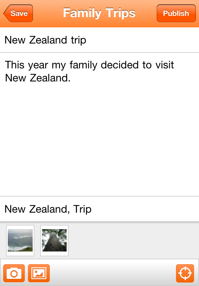
We’re excited to announce the new Blogger app for iOS. With the Blogger app, you can write a new blog post and publish it immediately or save it as a draft right from your iOS device. You can also open a blog post you’ve been working on from your computer and continue editing it while you’re on-the-go. Your blog posts are automatically synced across devices, so you’ll always have access to the latest version.
Pictures are worth a thousand words, and the Blogger app makes it easy to add photos either by choosing from the gallery or taking a new photo right within the app. You can also add labels and location to provide more details about the post.
Download the Blogger app today for iOS versions 3.2 and above in the App Store. Although the user interface is only available in English at this time, the app supports blog posts written in all languages. If you’re using an Android-powered device, you can download the Blogger app for Android from the Android Market.

 In addition, the map is fully functional on mobile devices.