The Changes Feed in the Documents List API

We’re announcing the availability of the Changes feed in the Documents List API. This feed makes it easier to detect resources that have changed.

Currently, clients needing to sync resources between Google Docs and other systems or device often encounter a number of issues detecting changes to resources via the API. Clients typically query for all resources modified after a given date. This date is denoted by the app:edited field of a resource entry. However, this field is not updated in all cases the client may care about, for instance if a resource is shared. In addition, querying for all resources modified after a given date does not produce entries for resources that have been deleted. This leads to very complex implementations of change detection by clients. These complex implementations usually have race conditions, and require a large volume of data to be exchanged with the API.

The Changes feed simplifies this process by providing resource entries only for changed resources. If a resource occurs in the Changes feed at all, the occurrence indicates a change to the resource. Once all changes are consumed, clients can store an identifier of the last change consumed. This identifier is called a changestamp. Future queries to the Changes feed with a changestamp will only return changes occurring after the given changestamp.

To start using the Changes feed, make an authorized HTTP GET request to the following URI:

https://docs.google.com/feeds/default/private/changes

The response from the API includes a Google Data API feed of resources that have changed:


    xmlns:openSearch="http://a9.com/-/spec/opensearch/1.1/"
    xmlns:docs="http://schemas.google.com/docs/2007" 
    xmlns:gd="http://schemas.google.com/g/2005"
    gd:etag="W/"DEEMQ3w8eyt7ImA9WhZUGUo."">
  5635
        href="...?start-index=5636"/>
  
            term="http://schemas.google.com/docs/2007#change" 
        label="change"/>
    Project tasks
    ...
    
  
  ...

Fields shown in this example response are discussed in detail in the updated developer guide.
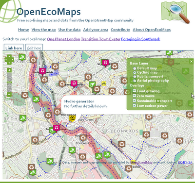
OpenEcoMaps – Free Eco-living Maps and Data

OpenEcoMaps provides free eco-living maps and data from OpenStreetMap


OpenEcoMaps

OpenEcoMaps Exeter,UK
But why?

There are lots of community groups, councils and companies out there mapping allotments, renewable energy generators, cycle routes and more. But they all suffer from two shortcomings:

1. Duplication – by putting their work into different places, different maps, we’re duplicating effort and not benefiting from each other’s work. For example, it’s common to find several different people all trying to map food growing spaces in the same part of town. Why not share?
2. Tools – not everybody has the tools to map these things, to put the results onto their web site or provide it to their council in the correct format.

OpenEcoMaps encourages people to share all their data in the same place – OpenStreetMap – and makes it easier for you to make use of the results.
How does it work?

OpenEcoMaps takes the data from OpenStreetMap (published under the Creative Commons Attribution-Sharealike 2.0 license), a community that is mapping the whole world and providing all of the information as open data. It takes a fresh data extract every hour and turns it into reusable KML Files, which can easily be displayed on a map.

Map of Exeter includes:

  • Cycling Map
  • Public Transport
  • Aerial Photography
  • Food growing
  • Zero Waste
  • Sustainable Transport
  • Low Carbon Power

http://www.openecomaps.co.uk/map.php?pack=TTE&zoom=1&lon=-3.51&lat=50.72

Source:
http://tom.acrewoods.net/2011/03/09/growing-pains-getting-data-out-of-openstreetmap/

More information:
http://wiki.openstreetmap.org/wiki/OpenEcoMaps
http://www.openecomaps.co.uk/about.php

Directions, the way you want them

We recently released advanced options for getting public transit directions on Google Maps, helping you customize your route based on your personal preferences.

We work hard to provide the right results to get from A to B, but sometimes riders have their own preferences. For example, you might not mind a longer journey if it means fewer transfers; or you may prefer traveling by bus or train, rather than subway, to have views of your route. You can now specify these preferences and alter your route results by clicking the “Show options” link below your destination:
We hope that this new feature makes it easier for you to find your way! To get started, please visit maps.google.com/transit.