A Place for everything, and everything in its Place

If someone asked you where you are right now, how would you answer? Would you say that you are at home, or at work? Maybe you are in a foreign country, in the park, or at your favourite coffee shop. These are just a few of the many places by which we navigate through our daily lives. Maps applications may see the world in terms of latitudes and longitudes, but we think in terms of ‘Places’.

In September of last year Google launched Place Pages on Google Maps. Each Place Page consolidates together everything we know about a single Place, be it a business, point of interest, or geographical feature such as a city or neighbourhood. We believe that this unified concept of Places more accurately reflects the way that Maps users see the world, and are working to bring an awareness of Places to the Google Maps API. At Google I/O today we offered a preview of the first Place related features that that are coming to the Google Maps API in the near future.

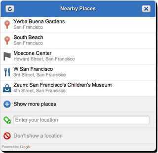
The Nearby Places widget is a user interface element that will launch in the Google Maps API v3. It combines the W3C Geolocation API with location based Place search to present the user with a list of Places in their immediate vicinity. The user can select a Place which the Maps API application can use as a check-in, or to tag content supplied by the user about that place. The application can also obtain more detailed information about the Place, such as the address, telephone number, and Place Page URL.

The Nearby Places widget is built on top of the Places Web Service, a new addition to the family of Google Maps API Web Services. The Places Web service offers search for nearby places to native mobile applications through an XML/JSON REST interface. In order for us to manage demand and ensure that the Places Web Service is used appropriately, applications will be required to authenticate their requests. If you are interested in using the service, check out the Places Web Service documentation which outlines the usage guidelines and application process. We expect to begin processing applications when the service launches in July.

We are also very excited to be working with Booyah, developers of the hugely popular MyTown iPhone application. The broad international coverage and superior performance of the Places Web Service made it the logical choice to serve the growing community of over two million active MyTown users. We were delighted to invite David Wang, Vice President of Business Development at Booyah, to speak at Google I/O about the ways in which they are integrating the Places Web Service into the MyTown application.

The Nearby Places widget and Places Web Service are our first steps towards tightly integrated and powerful support for discovering and understanding Places using the Google Maps API. Keep an eye on this blog for more information about the availability of these services, and other Place related launches in future.

Directions web service arrives at Google I/O

Google I/O is always a fantastic opportunity for the Maps API team to meet face to face with some of the many Maps API developers worldwide. We believe our developer community is one of the biggest strengths of the Google Maps API, and with over 350,000 web sites actively using the Maps API, there is no shortage of skilled and helpful expertise to tap into.

However Google I/O is not the only way in which we engage with developers. The Google Maps API Google Groups are thriving communities and many of us on the Maps API team enjoy listening and engaging in discussions held on these Groups. In addition we also have the Google Maps API Issue Tracker, a tool with which any Maps API developer can report problems with the API, suggest new features that they would benefit from, or star existing issues or features.

The Google Maps API team takes the problems and ideas featured on the Issue Tracker very seriously, and although we can not always address every issue that is raised, we do consider any that attract a lot of stars. Recently one feature request in particular has been head and shoulders above the rest in terms of the number of stars it has attracted. It therefore only seems appropriate today, as we sit down with our developer community for a Fireside Chat, that we respond to that request by launching a Directions Web Service.

The Directions Web Service is a companion to the existing Geocoding and Elevation Web Services, and allows applications to obtain Driving, Bicycling, and Walking directions through an XML/JSON REST interface. All of the features of the Map API v3 Directions service are supported, including “avoid highways”, “avoid tolls”, and waypoint optimization (travelling salesman solver). For more information, check out the Directions Web Services documentation.

If you have a great idea for a new Maps API feature, please don’t hesitate to submit it to the Issue Tracker. If your idea proves to be popular, we’ll do our best to make it a reality.

Posted by Thor Mitchell, Maps API Product Manager

Introducing Xtracked 2.0: Bigger, Better and more user-friendly than ever!

Since the Google Maps JavaScript API V2 has officially been deprecated, we decided to follow Google’s example and completely rewrite all of our JavaScript code from scratch to support their new and improved Google Maps JavaScript API V3. Ofcourse we couldn’t allow ourselves doing this without adding some cool new features along the way.

To start off with, we added the possibility to add personal notes to the dates you tracked your trips. We are planning on using this feature to allow you to not only select your tracks per date, but also by the description you gave them earlier.

Because Google’s default markers and their InfoWindow simply didn’t suffice for our cause, we had to come up with a solution of our own. Luckily the Google Maps API V3 supplied us with the tools we needed in the form of their MarkerImage and OverlayView classes. By implementing these, we are able to bring you the best mapping solution out there while staying faithfull to the Xtracked look and feel.

One feature we are all very keen about (and we know you have been waiting for) is Google Street View, allowing you to relive your trips through panoramic 360 degree views. Since we are a big fan of customizability, we leave it up to you whether to use Street View side-by-side with the map or as a standalone module.

Chart interaction has always been a very important aspect of the Xtracked website, but with the addition of Street View now more than ever. You will see that when hovering over the chart, not only is the map centered at your current location, but also does the Street View panorama reflect the actual view you had when passing that location (by setting its POV).

If you would want to find out more about a specific point, let’s say it’s address, the date and time you have been there or the speed at which you were travelling, than simply click the series in the chart and a popup with detailed information will appear on the map.

Zooming in is just as easy, just click, drag and release your mouse on a section of interest in the chart and the chart and map will automatically zoom in to the selected boundaries.

Last but not least, we even added the Google Maps ‘More…‘ menu with a Xtracked twist, allowing you to overlay your map with the Traffic and Bicycle Layer and switch to Satellite, OpenStreetMap and CloudMade map tiles.

We could go on and on about how psyched we are about the Maps API V3 and our implementation of it, but we would rather have you take a look at it yourself and tell us what you think. Check out our live demo at Xtracked.com, view the slides below or just browse through our online album.